Mazières-Naresse
| Mazières-Naresse | |
|---|---|
| Commune | |
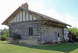 A stacked-beam house in Mazières-Naresse | |
 Mazières-Naresse Location within Nouvelle-Aquitaine region  Mazières-Naresse | |
| Coordinates: 44°39′14″N 0°42′18″E / 44.6539°N 0.705°ECoordinates: 44°39′14″N 0°42′18″E / 44.6539°N 0.705°E | |
| Country | France |
| Region | Nouvelle-Aquitaine |
| Department | Lot-et-Garonne |
| Arrondissement | Villeneuve-sur-Lot |
| Canton | Le Haut agenais Périgord |
| Intercommunality | Communauté de communes du Pays Villeréalais |
| Government | |
| • Mayor (2001–2008) | Jean-Paul Pape |
| Area1 | 8.93 km2 (3.45 sq mi) |
| Population (1999)2 | 137 |
| • Density | 15/km2 (40/sq mi) |
| Time zone | UTC+1 (CET) |
| • Summer (DST) | UTC+2 (CEST) |
| INSEE/Postal code | 47164 /47210 |
| Elevation |
75–116 m (246–381 ft) (avg. 90 m or 300 ft) |
|
1 French Land Register data, which excludes lakes, ponds, glaciers > 1 km2 (0.386 sq mi or 247 acres) and river estuaries. 2 Population without double counting: residents of multiple communes (e.g., students and military personnel) only counted once. | |
Mazières-Naresse is a commune in the Lot-et-Garonne department in south-western France.
See also
| Wikimedia Commons has media related to Mazières-Naresse. |
This article is issued from
Wikipedia.
The text is licensed under Creative Commons - Attribution - Sharealike.
Additional terms may apply for the media files.