Lagupie
| Lagupie | |
|---|---|
| Commune | |
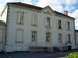 The town hall in Lagupie | |
 Lagupie Location within Nouvelle-Aquitaine region  Lagupie | |
| Coordinates: 44°33′27″N 0°06′56″E / 44.5575°N 0.1156°ECoordinates: 44°33′27″N 0°06′56″E / 44.5575°N 0.1156°E | |
| Country | France |
| Region | Nouvelle-Aquitaine |
| Department | Lot-et-Garonne |
| Arrondissement | Marmande |
| Canton | Les Coteaux de Guyenne |
| Intercommunality | Val de Garonne Agglomération |
| Government | |
| • Mayor (2008–2014) | Jean-Max Martin |
| Area1 | 8.69 km2 (3.36 sq mi) |
| Population (1999)2 | 489 |
| • Density | 56/km2 (150/sq mi) |
| Time zone | UTC+1 (CET) |
| • Summer (DST) | UTC+2 (CEST) |
| INSEE/Postal code | 47131 /47180 |
| Elevation |
20–121 m (66–397 ft) (avg. 29 m or 95 ft) |
|
1 French Land Register data, which excludes lakes, ponds, glaciers > 1 km2 (0.386 sq mi or 247 acres) and river estuaries. 2 Population without double counting: residents of multiple communes (e.g., students and military personnel) only counted once. | |
Lagupie is a commune in the Lot-et-Garonne department in south-western France.
See also
| Wikimedia Commons has media related to Lagupie. |
This article is issued from
Wikipedia.
The text is licensed under Creative Commons - Attribution - Sharealike.
Additional terms may apply for the media files.