Espiens
| Espiens | |
|---|---|
| Commune | |
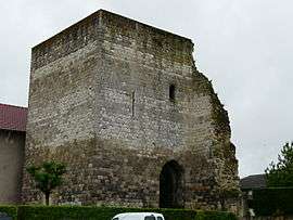 The tower in Espiens | |
 Espiens Location within Nouvelle-Aquitaine region  Espiens | |
| Coordinates: 44°10′12″N 0°22′42″E / 44.17°N 0.3783°ECoordinates: 44°10′12″N 0°22′42″E / 44.17°N 0.3783°E | |
| Country | France |
| Region | Nouvelle-Aquitaine |
| Department | Lot-et-Garonne |
| Arrondissement | Nérac |
| Canton | L'Albret |
| Intercommunality | Communauté de communes des Coteaux de l'Albret |
| Government | |
| • Mayor (2008–2014) | Guy Joffre |
| Area1 | 17.48 km2 (6.75 sq mi) |
| Population (1999)2 | 310 |
| • Density | 18/km2 (46/sq mi) |
| Time zone | UTC+1 (CET) |
| • Summer (DST) | UTC+2 (CEST) |
| INSEE/Postal code | 47090 /47600 |
| Elevation |
46–196 m (151–643 ft) (avg. 190 m or 620 ft) |
|
1 French Land Register data, which excludes lakes, ponds, glaciers > 1 km2 (0.386 sq mi or 247 acres) and river estuaries. 2 Population without double counting: residents of multiple communes (e.g., students and military personnel) only counted once. | |
Espiens is a commune in the Lot-et-Garonne department in south-western France.
See also
| Wikimedia Commons has media related to Espiens. |
This article is issued from
Wikipedia.
The text is licensed under Creative Commons - Attribution - Sharealike.
Additional terms may apply for the media files.