Astoria Boulevard (BMT Astoria Line)
Astoria Blvd | |||||||||
|---|---|---|---|---|---|---|---|---|---|
|
| |||||||||
 | |||||||||
| Station statistics | |||||||||
| Address |
Astoria Boulevard & 31st Street Astoria, NY 11102 | ||||||||
| Borough | Queens | ||||||||
| Locale | Astoria | ||||||||
| Coordinates | 40°46′12″N 73°55′05″W / 40.769979°N 73.918161°WCoordinates: 40°46′12″N 73°55′05″W / 40.769979°N 73.918161°W | ||||||||
| Division | B (BMT) | ||||||||
| Line | BMT Astoria Line | ||||||||
| Services |
N W | ||||||||
| Transit connections |
| ||||||||
| Structure | Elevated | ||||||||
| Platforms |
2 island platforms cross-platform interchange | ||||||||
| Tracks | 3 (2 in regular service) | ||||||||
| Other information | |||||||||
| Opened | February 1, 1917[1] | ||||||||
| Station code | 002[2] | ||||||||
| Accessible | not ADA-accessible; accessibility planned | ||||||||
| Former/other names | Astoria Boulevard–Hoyt Avenue | ||||||||
| Traffic | |||||||||
| Passengers (2017) |
5,031,462[3] | ||||||||
| Rank | 95 out of 425 | ||||||||
| Station succession | |||||||||
| Next north |
Astoria–Ditmars Boulevard: N | ||||||||
| Next south |
30th Avenue (local): N Queensboro Plaza (express): no regular service | ||||||||
| |||||||||
| |||||||||
| |||||||||


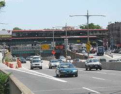
Astoria Boulevard (also known as Astoria Boulevard–Hoyt Avenue) is an express station on the BMT Astoria Line. Located above 31st Street at Astoria Boulevard and the Grand Central Parkway in Astoria, Queens, the station is served by the N train at all times, as well as by the W train on weekdays.
History

This station opened on February 1, 1917, along with the rest of the Astoria Line, which was originally part of the IRT, as a spur off the IRT Queensboro Line, now the IRT Flushing Line. Trains ran between Grand Central and Astoria.[1][4] On July 23, 1917, the Queensboro Bridge spur of the elevated IRT Second Avenue Line opened. At that time, all elevated trains to Queensboro Plaza used the Astoria Line while all subway trains used the Corona Line, though this was later changed with trains alternating between branches.[4][5] This station started to be served by BMT shuttles using elevated cars on April 8, 1923.[6]
On October 17, 1949, the Astoria Line became BMT-only as the tracks at Queensboro Plaza were consolidated and the platforms on the Astoria Line were shaved back to allow through BMT trains to operate on it. Service was initially provided by the Brighton Local (BMT 1) weekdays & Broadway - Fourth Avenue Local (BMT 2) at all times.[7]
The platforms at this station, along with six others on the Astoria Line, were lengthened to 610 feet (190 m) to accommodate ten-car trains in 1950.[8]:23 The project cost $863,000. Signals on the line had to be modified to take into account the platform extensions.[9]:633, 729
On the morning of May 1, 1998, a backhoe working underneath the station (not performing New York City Transit-related work) struck the mezzanine, ripping out three support beams while damaging four more and creating a huge hole in the floor. There were no injuries, but trains bypassed the station at restricted speed. Cleanup work began immediately and by noon, the slow speed restriction was removed. By 3:00 p.m., a temporary wooden floor was installed. Less than eight hours from the time of the first response, the station was back in full service. Permanent repairs were made overnight.[10]
In September 2018, work will begin to make the station compliant with the Americans with Disabilities Act of 1990. Two elevators will be installed between the street and the mezzanine, and two elevators will connect the mezzanine with the two platforms. In order to construct the street elevators, the station mezzanine will be demolished and rebuilt. The new mezzanine will be raised to reduce strikes by trucks driving underneath. Starting February 2019, the station will be fully closed for nine months so the mezzanine could be replaced.[11]
Station layout
| P Platforms |
Southbound local | ← ← |
| Island platform, doors will open on the left | ||
| Peak-direction express | ← No regular service (No service: Queensboro Plaza southbound or Astoria–Ditmars Boulevard northbound) | |
| Island platform, doors will open on the left | ||
| Northbound local | → | |
| M | Mezzanine | two entrances/exits, station agent, MetroCard vending machines |
| G | Street Level | Entrances/Exits |
The elevated station has three tracks and two island platforms. The center track is not used in revenue service, but it had been used regularly as recently as 2002.[12]
The station has wooden canopies with transite and wooden mezzanines. The northbound platform’s benches are surrounded by low windscreen on three sides. The southbound platform bears the tertiary name of Columbus Square, for a small park containing a statue of Columbus by Angelo Racioppi immediately east of the southeastern stair of the station. It also has an enclosed waiting area.
Exits

This station affords a view of the Hell Gate Bridge and viaduct to the north, Triborough Bridge to the west, and the Grand Central Parkway (Interstate 278) and Hoyt Avenue underneath. These three structures forced a change in the station. The overpass to the far north exit was an addition because of the Triborough Bridge’s construction in 1936. The parkway forced relocation of the north exit stairways since the parkway was too wide for the original stairways. The southern stairways are original. The mezzanine has separate turnstile banks from each side with crossunders from the platform stairs.
Essentially, there are four exits to the station: two to either northern corner of Hoyt Avenue North and 31st Street (via overpass), and two to either southern corner of Hoyt Avenue South and 31st Street.[13]
References
- 1 2 "First Train Runs On Elevated Line to Astoria Section". Brooklyn Daily Eagle. February 1, 1917. Retrieved June 29, 2015 – via Newspapers.com.
- ↑ "Station Developers' Information". Metropolitan Transportation Authority. Retrieved June 13, 2017.
- ↑ "Facts and Figures: Annual Subway Ridership 2012–2017". Metropolitan Transportation Authority. July 12, 2018. Retrieved July 12, 2018.
- 1 2 Annual report. 1916-1917. New York: Interborough Rapid Transit Company. 1917.
- ↑ "Subway Link Over Queensboro Bridge". The New York Times. July 22, 1917. p. 31. Retrieved December 18, 2011.
- ↑ "Additional Subway Service to Borough of Queens". The New York Times. April 8, 1923. p. RE1. Retrieved December 18, 2011.
- ↑ "Direct Subway Runs to Flushing, Astoria". The New York Times. October 15, 1949. p. 17. Retrieved December 18, 2011.
- ↑ Association, General Contractors (1950). Bulletin.
- ↑ Transportation, New York (N Y. ) Board of (1950). Proceedings ...
- ↑ Mbugua, Martin; Rutenberg, James (May 2, 1998). "Backhoe Cripples El". Daily News. Retrieved April 11, 2010.
- ↑ "MTA New York City Transit to Bring Elevators to Astoria Blvd Station". www.mta.info. Metropolitan Transportation Authority. April 17, 2018. Retrieved April 18, 2018.
- ↑ Dougherty, Peter (2006) [2002]. Tracks of the New York City Subway 2006 (3rd ed.). Dougherty. OCLC 49777633 – via Google Books.
- ↑ "MTA Neighborhood Maps: Astoria" (PDF). Metropolitan Transportation Authority. 2015. Retrieved September 27, 2015.
External links
| Wikimedia Commons has media related to Astoria Boulevard (BMT Astoria Line). |
- nycsubway.org – BMT Astoria Line: Astoria Boulevard/Hoyt Avenue
- Station Reporter — N Train
- Astoria Boulevard entrance from Google Maps Street View
- Hoyt Avenue entrance from Google Maps Street View
- Platforms from Google Maps Street View
| Astoria Line | |
|---|---|
| |