Quetta District
| Quetta کوئٹہ | |
|---|---|
| District | |
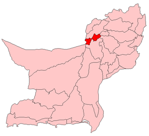 Map of Balochistan with Quetta District highlighted | |
| Coordinates: 30°10′N 67°00′E / 30.167°N 67.000°ECoordinates: 30°10′N 67°00′E / 30.167°N 67.000°E | |
| Country | Pakistan |
| Province | Balochistan |
| Division | Quetta Division |
| Established | April 1983 |
| Headquarters | Quetta |
| Government | |
| • Deputy Commissioner | Lateef Kakar[1] |
| • District Mayor | Kaleemullah Kakar |
| Area[2] | |
| • Total | 2,653 km2 (1,024 sq mi) |
| Population (2017)[3] | |
| • Total | 2,275,699 |
| • Density | 860/km2 (2,200/sq mi) |
| Time zone | UTC+5 (PKT) |
| Number of Tehsils | 2 |
| Website |
www |
Quetta (Pashto: کوټه, Urdu: کوئٹہ) is a district in the north-west of Balochistan province of Pakistan. It is part of Quetta Division. The district is famous for its agriculture produce, most notably fruit orchards but also including apples and grapes. The Hanna Valley is an area where almonds are grown. The population counted in the 1998 census was 760,000, while in 2010 it was estimated at 1,235,000.[4]
History
The ancient name of Quetta was Shalkot, a term by which it is still known among the people of the country. The district was held in turns by the Ghaznavids, Ghurids, and Mongols, and towards the end of the fifteenth century was conferred by the ruler of Herat on Shah Beg Arghun, who, however, had shortly to give way before the rising power of the Mughals. The Ain-i-Akbari mentions both Shal and Pishin as supplying military service and revenue to Akbar, however these areas passed with Kandahar to the Safavids. On the rise of the Khalji power in Kandahar at the beginning of the eighteenth century, simultaneously with that of the Baloch in Kalat, Quetta and Pishin became the battle-ground between Afghan and Baloch, Ahmad Shah Durrani Finally handed Quetta over to the Khan of Kalat Mir Noori Naseer Khan Baloch for helping him with his Baloch Army against Persians in Iran in 1751 against Marathas in Third Battle of Panipat (1761) and against Sikh in 1765 .[5]
British Era
During the 19th century Quetta (Shalkot) was captured by the British troops during the Second Anglo-Afghan War of 1879.
On the advance of the British Army of the Indus in 1839, Captain Bean was appointed the first Political Agent in ShalKot, and the country was managed by him on behalf of Shah Shuja-ul-mulk. After Sir Robert Sandeman's mission to Kalat in 1876, the Quetta Fort was occupied by his escort and the country was managed on behalf of the Khan of Kalat up to 1883, when it was leased to the British Government for an annual rent of Rs. 25,000 through a treaty between Khan and the British Empire. It was formed, with Pishin and Shorarud, into a single administrative charge in 1883. Up to 1888 Old Chaman was the most advanced post on the frontier; but, on the extension of the railroad across the Khwaja Amran, the terminus was fixed at its present site, 7 miles (11 km) from that place. The boundary with Afghanistan was finally demarcated in 1895–6.[5]
The city area of Shalkot was inhabited by the Kasi tribe. Being on the outskirts of Kandahar, it was not much developed. With the arrival of British troops, doors of development were opened. Very soon people saw roads, trains and schools in the area.
Administrative divisions
Subdivisions
In 1975, Quetta and Pishin were made separate districts. Quetta District today consists of two towns,[6] and one sub-tehsil.District Quetta was declared as City District in 2001 having three tehsils and 67 Union councils.
Provincial assembly
The district is represented in the provincial assembly by six constituencies.[7]
Demographics
In 1998, 74% of the population resided in urban areas.[8] The major religion is Islam (96%), but there are also Christian (2.7%) and Hindu (0.5%) communities.[9] The most common first languages according to the 1998 census are Pashto (30%), Balochi (28%) and Punjabi (16%).[10] The number for Balochi speakers also includes speakers of Brahui, who are normally bilingual with Balochi. Languages in the 1981 census were counted at the level of the household: Pashto was the language of 36% of households, Punjabi – of 19%, Brahui – of 17%, Urdu – of 11% and Balochi – of 5.1%.[11] There is also a population of Hazaras.[12]
Notable people
References
- ↑ http://photos.ummat.net/displayimage.php?pid=1515
- ↑ 1998 Census, p. 1.
- ↑ "DISTRICT WISE CENSUS RESULTS CENSUS 2017" (PDF). www.pbscensus.gov.pk. Archived from the original (PDF) on 2017-08-29.
- ↑ PDD 2011, p. viii.
- 1 2 Quetta-Pishin - Imperial Gazetteer of India, v. 21, p. 13-4
- ↑ Towns & Unions in the City District of Quetta Archived February 9, 2012, at the Wayback Machine.
- ↑ Provincial Assembly – Balochistan
- ↑ 1998 Census, pp. 17, 21.
- ↑ 1998 Census, p. 20.
- ↑ 1998 Census, p. 22.
- ↑ 1981 Census, p. 77.
- ↑ 1998 Census, p. 7.
Bibliography
- 1981 District census report of Quetta. District census report. 2. Islamabad: Population Census Organization, Statistics Division, Government of Pakistan. 1983.
- 1998 District census report of Quetta. Census publication. 158. Islamabad: Population Census Organization, Statistics Division, Government of Pakistan. 2001.
- Planning & Development Department, Government of Balochistan (2011). Quetta District Development Profile (PDF) (Report).
External links
| Wikimedia Commons has media related to Quetta District. |
Neighbourhoods of Quetta | ||
|---|---|---|
Administrations: Quetta Division and Quetta District | ||
| Tehsils |
|  |
| Cities |
| |
| Towns and councils | ||
| Localities | ||
Website: Quetta District at NRB | ||