Kohlu District
| Kohlu District | |
|---|---|
| District | |
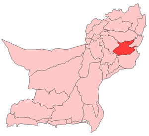 Map of Balochistan Districts with Kohlu District highlighted | |
| Country | Pakistan |
| Province | Balochistan |
| Headquarters | Kohlu |
| Government | |
| • Chief of Marri | Nawab Changez Khan Marri |
| • Chief of Zarkoon | Sardar Abdul Rasheed Zarkoon |
| Area[1] | |
| • Total | 7,610 km2 (2,940 sq mi) |
| Population (2017)[2] | |
| • Total | 214,350 |
| • Density | 28/km2 (73/sq mi) |
| Time zone | UTC+5 (PST) |
| Number of Tehsils | 3 |
Kohlu (Urdu and Balochi: کوہلو) is a district of the Balochistan province of Pakistan. It is bounded in the north by Loralai District, Dera Bugti in the south, in the east Rojhan-Mazari and Sibi District in the west. According to the 1998 census of Pakistan it had a population of 99,850.[3] The most widely spoken first languages are Balochi (91%) and Pashto (6.6%).[4] The major ethnic groups in kohlu includes Marri and Zarkoon.
Education
According to the Pakistan District Education Rankings 2017, district Kohlu is ranked at number 116 out of the 141 ranked districts in Pakistan on the education score index. This index considers learning, gender parity and retention in the district.
Literacy rate in 2014-15 of population 10 years and older in the district stands at 32% whereas for females it is only 12%.[5]
Post primary access is a major issue in the district with 91% schools being at primary level. Compare this with high schools which constitute only 4% of government schools in the district. This is also reflected in the enrolment figures for 2016-17 with 2,754 students enrolled in class 1 to 5 and only 8 students enrolled in class 9 and 10.
Gender disparity is another issue in the district. Only 20% schools in the district are girls’ schools. Access to education for girls is a major issue in the district and is also reflected in the low literacy rates for females.
Moreover, the schools in the district lack basic facilities. According to Alif Ailaan district education rankings 2017, the district is ranked at number 150 out of the 155 districts of Pakistan for primary school infrastructure. At the middle school level, it is ranked at number 149 out of the 155 districts. These rankings take into account the basic facilities available in schools including drinking water, working toilet, availability of electricity, existence of a boundary wall and general building condition. More than 4 out of 5 schools do not have electricity in them. 9 out 10 schools lack a toilet and 3 out of 4 schools do not have a boundary wall. 1 out of 2 schools do not have clean drinking water.
The main issues reported in Taleem Do! App for the district is the unavailability of teachers in schools.
See also
References
- ↑ PCO 1999, p. 13.
- ↑ "DISTRICT WISE CENSUS RESULTS CENSUS 2017" (PDF). www.pbscensus.gov.pk.
- ↑ PCO 1999, p. 27.
- ↑ PCO 1999, p. 32.
- ↑ Pakistan Bureau of Statistics (2016). Pakistan Social and Living Standards Measurement Survey 2014-15. [online] Islamabad: Government of Pakistan, p.111. Available at: http://www.pbs.gov.pk/sites/default/files//pslm/publications/PSLM_2014-15_National-Provincial-District_report.pdf [Accessed 6 Aug. 2018].
Bibliography
- 1998 District census report of Kohlu. Census publication. 22. Islamabad: Population Census Organization, Statistics Division, Government of Pakistan. 1999.
External links
| Wikimedia Commons has media related to Kohlu District. |