Urak Valley
| Urak Valley | |
|---|---|
| Valley | |
 Urak Valley in Quetta | |
 Urak Valley | |
| Coordinates: 30°16′31″N 67°11′32″E / 30.275400°N 67.192168°ECoordinates: 30°16′31″N 67°11′32″E / 30.275400°N 67.192168°E[1] | |
| Country |
|
| Province | Balochistan |
| District | Quetta District |
| Time zone | UTC+5 (PST) |
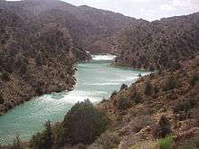
Urak Valley is a valley surrounded by mountains in the Quetta District of Balochistan Province, in western Pakistan. Urak Valley is located near Hana Lake, and 21 kilometres (13 mi) from Quetta city.[2] A small waterfall at its end marks entrance to the adjacent Wali Tangi Dam.
Urak Valley has a population of 10,000, and is nearly 100% Kakar. Agriculture in the valley includes growing apple trees of good quality and a few other fruits.[3]
Gallery


 End of Urak Valley
See also
| Wikimedia Commons has media related to Urak Valley. |
References
- ↑ "Urak Valley on Maps". Google Maps. Retrieved 12 August 2018.
- ↑ "Distance from Quetta and surrounded by mountains". www.merawatan.pk. Retrieved 4 June 2018.
- ↑ "Population and Agriculture". pakistantourism.net. Retrieved 4 June 2018.
This article is issued from
Wikipedia.
The text is licensed under Creative Commons - Attribution - Sharealike.
Additional terms may apply for the media files.