Awaran District
| Awaran آواران | |
|---|---|
| District | |
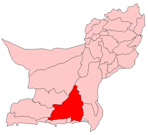 Map of Pakistani districts with Awaran district highlighted in maroon | |
| Country | Pakistan |
| Province | Balochistan |
| Notified | 11 November 1992[1] |
| Headquarters | Awaran |
| Government | |
| • Members of National Assembly | Jam Kamal Khan (NA-270) |
| Area | |
| • Total | 21,630 km2 (8,350 sq mi) |
| Population (2017)[2] | |
| • Total | 121,680 |
| • Density | 5.6/km2 (15/sq mi) |
| Time zone | UTC+5 (PKT) |
| Number of Tehsils | 3 |
| Tehsils |
Awaran Jhal Jhao Mashkai |
| Website | www.bdd.sdnpk.org/awaran.htm |
Awaran District (Balochi and Urdu: ضِلع آواران), is a district in the south of the Balochistan province of Pakistan. It was created as a separate district in November 1992; but previously it was a sub-division of Khuzdar District.[3] The old name of Awaran was Kolwa. It is considered the poorest district in the province.[4]
It is located in the south of the Balochistan province, Awaran district is bordered by Gwadar to its south and south west, Lasbela to its east and south, Kech and Panjgur to its west, Khuzdar to its north east and Kharan to its north.
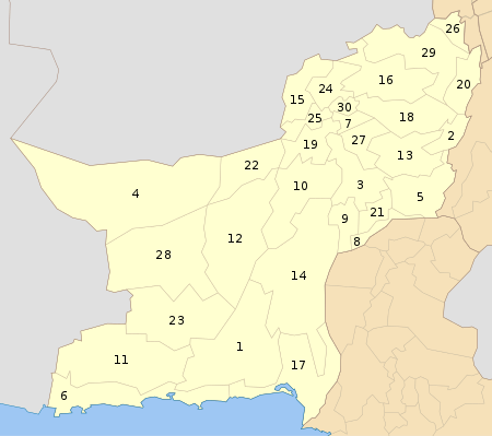
Administrative divisions
The district is administratively subdivided into the following three tehsils,[5] which are sub-divided into eight union councils:[6]
Demographics
The population of the district was as follows:
Over 98% of the people of the area are Muslims[8] with a small Zikri minority. The major tribes are the Bizenjo, Muhammad Hassani, Sajdi, Siapad, Mirwani, Rakhshani, Musiani, Sumalani and Mengal.[9] The predominant language is Balochi which accounted for 99.7% of the population in the 1998 census.[10] The previous census of 1981 reported that 8% of the households in the then subdivision of Awaran had Brahui as a first language.[11]
Agriculture
Awaran is known as oasis of dates. Annual production of dates is approx 15,000 ton. Beside dates, onion is grown on large scale; estimated annual production is 53,000 tons. Wheat and barley are the other major Rabi crop. Kharif crops are fruits and pulses.
Education
According to Pakistan District Education Ranking 2017, a report by Alif Ailaan, district Awaran is ranked at number 137 nationally, with an education score of 37.65. The learning score of Awaran is 42.13 and gender parity is at 43.37.
The national rank according to Readiness is 148, with a readiness score of 26.47 and primary ratio of 22.17 and gender parity of 30.77. The school infrastructure score is at 20.09 giving district Awaraan a national ranking of 146. Availability of electricity and functional toilets in schools are a major issue in Awaran.
The main issue reported in TaleemDo! App relates to lack of quality teachers, subject specialist and the teacher absentee rate is very high. There's a huge problem of ghost teachers.
See also
References
- ↑ Awaran Archived 31 August 2011 at the Wayback Machine. UN profile. Retrieved 6 September 2010.
- ↑ "DISTRICT WISE CENSUS RESULTS CENSUS 2017" (PDF). www.pbscensus.gov.pk.
- ↑ 1998 Census report, p. 1.
- ↑ Awaran District Balochistan Flood Assessment pg 6. July 2007 Archived 11 March 2012 at the Wayback Machine. PDI, Khuzdar. Retrieved 6 September 2010.
- 1 2 3 4 Awaran District Archived 1 June 2012 at the Wayback Machine. Government of Balochistan. Retrieved 24 July 2012
- ↑ Tehsils & Unions in the District of Awaran - Government of Pakistan
- 1 2 Awaran District Archived 12 September 2011 at the Wayback Machine. Population Census Organisation, Government of Pakistan. Retrieved 6 September 2010.
- 1 2 Awaran District Balochistan Flood Assessment pg 4. July 2007 Archived 11 March 2012 at the Wayback Machine. PDI, Khuzdar. Retrieved 6 September 2010.
- ↑ 1998 Census report, p. 5.
- ↑ 1998 Census report, p. 16.
- ↑ 1981 Census report, p. 84.
Bibliography
- 1981 District census report of Khuzdar. Census publication. 12. Islamabad: Population Census Organization, Statistics Division, Government of Pakistan. 1983.
- 1998 District census report of Awaran. Census publication. 89. Islamabad: Population Census Organization, Statistics Division, Government of Pakistan. 2000.
External links
| Wikimedia Commons has media related to Awaran District. |