Zhob District
| Zhob ژوب | |
|---|---|
| District | |
 Much of Zhob District consists of rugged terrain | |
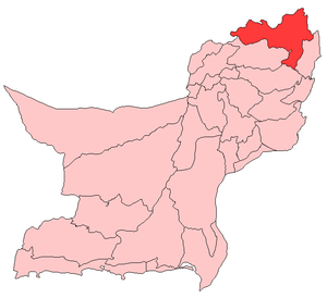 Map of Balochistan with Zhob District highlighted | |
| Country | Pakistan |
| Province | Balochistan |
| Headquarters | Zhob |
| Government | |
| • District chairman | Abdul saleem Mandokhail |
| Area | |
| • Total | 20,297 km2 (7,837 sq mi) |
| Population (2017)[1] | |
| • Total | 310,544 |
| • Density | 15/km2 (40/sq mi) |
| Time zone | PKT |
| Number of Tehsils | 5 |
| Main Language(s) | Pashto |
Zhob (Urdu: (ژوب) ږوب in Pashto) is a district in the north west of Balochistan province of Pakistan. Zhob District is a Provincially Administered Tribal Area. The population of Zhob District is estimated to 310,544 in 2017[1]. Zhob River is used for irrigation in the Zhob District.
Administration
The 1998 census report lists two sub-divisions: Lower Zhob (comprising Zhob tehsil and Sambaza sub-tehsil) and Kakar Khurasan (encompassing the tehsil of Qamar Din Karez and the subtehsil of Ashewat).[2] A government webpage lists these as Ashwat, Qamar Din Karez, Sambaza and Zhob, without indicating if any of them are sub-tehsils.[3]
Demography
The 1998 census counted a total population of 193,000 in the two subdistricts of Kakar Khurasan and Zhob (the third subdistrict has since been established as the separate Sherani District). The majority of the population (96%) have Pashto as their first language, but there are also speakers of Saraiki (1.8%) and Punjabi (1.77%).[4]
The vast majority of the population of Zhob district is Pashtun. The indigenous tribes of Zhob include the Mandokhail, Khosti, Sherani, Kakar, Harifal, Lawon and Babar. Currently a large number of IDPs have been settled within the confines of the District as part of the evacuation from Operation Zarb-E-Azb taking place to the north of Zhob.
References
- 1 2 "DISTRICT WISE CENSUS RESULTS CENSUS 2017" (PDF). www.pbscensus.gov.pk.
- ↑ PCO 1998, p. 10.
- ↑ "List of Tehsils/Talukas with respect to their Districts" Federal Bureau of Statistics, Pakistan Archived 30 December 2010 at the Wayback Machine.
- ↑ PCO 1998, table 10.
Bibliography
- 1998 District Census report of Zhob. Census publication. 107. Islamabad: Population Census Organization, Statistics Division, Government of Pakistan. 2000.
External links
| Wikimedia Commons has media related to Zhob District. |
www.zamazhob.asia Zhob District at www.balochistan.gov.pk
Coordinates: 31°10′N 68°50′E / 31.167°N 68.833°E