Chamdo
| Qamdo 昌都市 ཆབ་མདོ་གྲོང་ཁྱེར། | |
|---|---|
| Prefecture-level city | |
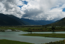 Mekong River to the south of Chamdo Town | |
 prefecture (orange) in Tibet (light-orange) | |
| Country | People's Republic of China |
| Region | Tibet |
| Prefecture seat | Karub District (Chengguan) |
| Area | |
| • Total | 110,154 km2 (42,531 sq mi) |
| Elevation | 3,240 m (10,630 ft) |
| Population | |
| • Total | 657,505 |
| • Density | 6.0/km2 (15/sq mi) |
| Time zone | UTC+8 (China Standard) |
| ISO 3166 code | CN-XZ-03 |
| Chamdo | |||||||
 | |||||||
| Chinese name | |||||||
|---|---|---|---|---|---|---|---|
| Chinese | 昌都 | ||||||
| |||||||
| Tibetan name | |||||||
| Tibetan | ཆབ་མདོ་གྲོང | ||||||
| |||||||
Chamdo, officially Qamdo,[1][2] and known in Chinese as Changdu,[3] is a prefecture-level city in the eastern part of the Tibet Autonomous Region, China. Its seat is the town of Chengguan in Karuo District. Chamdo is Tibet's third largest city after Lhasa and Shigatse.[4]
History
On 11 July 2014 Chamdo Prefecture was upgraded into a prefecture-level city.[5]
Transportation
Air
Qamdo Bamda Airport, opened in 1994, is located 126 kilometres (78 miles) from Chengguan Town in Karub District. The long commute (2.5 hours by mountain road) is the result of no flat land closer to the city being available to construct an airport.
Road
China National Highway 214 and China National Highway 317 are the main roads in and out of Chamdo.
Subdivisions
The city is subdivided into 11 county-level divisions: 1 district and 10 counties
| Map | ||||||||
|---|---|---|---|---|---|---|---|---|
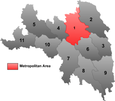 | ||||||||
| # | Name | Hanzi | Hanyu Pinyin | Tibetan | Wylie | Population (2010 Census) | Area (km²) | Density (/km²) |
| 1 | Karuo District | 卡若区 | Kǎruò Qū | མཁར་རོ་ཆུས། | mkhar ro chus | 116,500 | 10,794 | 10.79 |
| 2 | Jomda County | 江达县 | Jiāngdá Xiàn | འཇོ་མདའ་རྫོང་། | 'jo mda' rdzong | 76,026 | 13,164 | 5.77 |
| 3 | Gonjo County | 贡觉县 | Gòngjué Xiàn | གོ་འཇོ་རྫོང་། | go 'jo rdzong | 40,434 | 6,323 | 6.39 |
| 4 | Riwoqê County | 类乌齐县 | Lèiwūqí Xiàn | རི་བོ་ཆེ་རྫོང་། | ri bo che rdzong | 49,870 | 6,355 | 7.84 |
| 5 | Dêngqên County | 丁青县 | Dīngqīng Xiàn | སྟེང་ཆེན་རྫོང་། | steng chen rdzong | 69,888 | 12,408 | 5.63 |
| 6 | Zhag'yab County | 察雅县 | Cháyǎ Xiàn | བྲག་གཡབ་རྫོང་། | brag g-yab rdzong | 56,789 | 8,251 | 6.88 |
| 7 | Baxoi County | 八宿县 | Bāsù Xiàn | དཔའ་ཤོད་རྫོང་། | dpa' shod rdzong | 39,021 | 12,336 | 3.16 |
| 8 | Zogang County | 左贡县 | Zuǒgòng Xiàn | མཛོ་སྒང་རྫོང་། | mdzo sgang rdzong | 44,320 | 11,837 | 3.74 |
| 9 | Markam County | 芒康县 | Mángkāng Xiàn | སྨར་ཁམས་རྫོང་། | smar khams rdzong | 81,399 | 11,576 | 7.03 |
| 10 | Lhorong County | 洛隆县 | Luòlóng Xiàn | ལྷོ་རོང་རྫོང་། | lho rong rdzong | 47,491 | 8,048 | 5.90 |
| 11 | Banbar County | 边坝县 | Biānbà Xiàn | དཔལ་འབར་རྫོང་། | dpal 'bar rdzong | 35,767 | 8,774 | 4.07 |
Climate
Chamdo has a humid continental climate (Köppen: Dwb) in the Karub District and an alpine subarctic climate (Köppen: Dwc) in other counties.
| Climate data for Karub District,Chamdo | |||||||||||||
|---|---|---|---|---|---|---|---|---|---|---|---|---|---|
| Month | Jan | Feb | Mar | Apr | May | Jun | Jul | Aug | Sep | Oct | Nov | Dec | Year |
| Record high °C (°F) | 21.8 (71.2) |
21.4 (70.5) |
26.1 (79) |
28.1 (82.6) |
29.5 (85.1) |
32.7 (90.9) |
32.0 (89.6) |
30.8 (87.4) |
30.5 (86.9) |
27.7 (81.9) |
22.3 (72.1) |
20.2 (68.4) |
32.7 (90.9) |
| Average high °C (°F) | 8.7 (47.7) |
10.2 (50.4) |
13.3 (55.9) |
16.6 (61.9) |
20.9 (69.6) |
23.6 (74.5) |
24.2 (75.6) |
23.5 (74.3) |
21.6 (70.9) |
17.6 (63.7) |
12.7 (54.9) |
9.5 (49.1) |
16.9 (62.4) |
| Daily mean °C (°F) | −1.6 (29.1) |
1.0 (33.8) |
4.7 (40.5) |
8.1 (46.6) |
12.2 (54) |
15.3 (59.5) |
16.3 (61.3) |
15.5 (59.9) |
13.1 (55.6) |
8.4 (47.1) |
2.4 (36.3) |
−1.5 (29.3) |
7.8 (46.1) |
| Average low °C (°F) | −9.6 (14.7) |
−6.8 (19.8) |
−2.4 (27.7) |
1.4 (34.5) |
5.3 (41.5) |
9.2 (48.6) |
10.6 (51.1) |
10.0 (50) |
7.3 (45.1) |
1.8 (35.2) |
−5 (23) |
−9.3 (15.3) |
1 (33.9) |
| Record low °C (°F) | −19.4 (−2.9) |
−17.4 (0.7) |
−13 (9) |
−7.7 (18.1) |
−4 (25) |
1.1 (34) |
2.9 (37.2) |
1.1 (34) |
−0.9 (30.4) |
−7 (19) |
−13.6 (7.5) |
−20.7 (−5.3) |
−20.7 (−5.3) |
| Average precipitation mm (inches) | 1.2 (0.047) |
3.3 (0.13) |
11.3 (0.445) |
24.4 (0.961) |
39.3 (1.547) |
85.9 (3.382) |
106.5 (4.193) |
100.5 (3.957) |
74.6 (2.937) |
34.6 (1.362) |
5.7 (0.224) |
2.0 (0.079) |
489.3 (19.264) |
| Source: China Meteorological Administration,[6] | |||||||||||||
References
- ↑ Guójiā cèhuìjú dìmíng yánjiūsuǒ 国家测绘局地名研究所: Zhōngguó dìmínglù 中国地名录 (Gazetteer of China; Beijing, SinoMaps Press 中国地图出版社 1997); ISBN 7-5031-1718-4, p. 27.
- ↑ "New city to be established in China's Tibet". The State Council of the People's Republic of China. Xinhua. Retrieved 9 August 2017.
- ↑ Powers, John (2016). "Appendix B". The Buddha Party: How the People's Republic of China Works to Define and Control Tibetan Buddhism (1st ed.). New York: Oxford University Press. ISBN 9780199358151.
PINYIN= Changdu Zhen
- ↑ Buckley and Straus 1986, p. 215.
- ↑ Yang, Shoude. "西藏东部昌都地区将撤地设市 已获国务院批复". qh.xinhuanet.com. Xinhua. Archived from the original on 6 November 2014. Retrieved 5 November 2014.
- ↑ 中国地面国际交换站气候标准值月值数据集(1981-2010年) (in Chinese). China Meteorological Administration. Retrieved January 1, 2011.