Puch-d'Agenais
| Puch-d'Agenais | ||
|---|---|---|
| Commune | ||
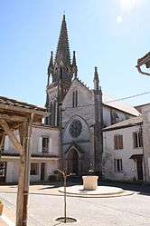 View of downtown | ||
| ||
 Puch-d'Agenais Location within Nouvelle-Aquitaine region  Puch-d'Agenais | ||
| Coordinates: 44°19′46″N 0°14′39″E / 44.3294°N 0.2442°ECoordinates: 44°19′46″N 0°14′39″E / 44.3294°N 0.2442°E | ||
| Country | France | |
| Region | Nouvelle-Aquitaine | |
| Department | Lot-et-Garonne | |
| Arrondissement | Nérac | |
| Canton | Lavardac | |
| Intercommunality | Communauté de communes du Confluent | |
| Government | ||
| • Mayor (2001–2008) | Guy Bru | |
| Area1 | 23 km2 (9 sq mi) | |
| Population (1999)2 | 651 | |
| • Density | 28/km2 (73/sq mi) | |
| Time zone | UTC+1 (CET) | |
| • Summer (DST) | UTC+2 (CEST) | |
| INSEE/Postal code | 47214 /47160 | |
| Elevation |
27–123 m (89–404 ft) (avg. 100 m or 330 ft) | |
|
1 French Land Register data, which excludes lakes, ponds, glaciers > 1 km2 (0.386 sq mi or 247 acres) and river estuaries. 2 Population without double counting: residents of multiple communes (e.g., students and military personnel) only counted once. | ||

Puch-d'Agenais is a commune in the Lot-et-Garonne department in south-western France.
See also
| Wikimedia Commons has media related to Puch-d'Agenais. |
This article is issued from
Wikipedia.
The text is licensed under Creative Commons - Attribution - Sharealike.
Additional terms may apply for the media files.