Point Reyes Station, California
| Point Reyes Station | |
|---|---|
| Census-designated place | |
.JPG) State Route 1 runs through Point Reyes Station | |
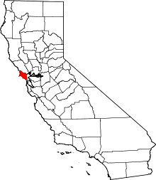
 Location in Marin County and the state of California | |
 Point Reyes Station Location in the United States | |
| Coordinates: 38°04′09″N 122°48′25″W / 38.06917°N 122.80694°WCoordinates: 38°04′09″N 122°48′25″W / 38.06917°N 122.80694°W | |
| Country |
|
| State |
|
| County | Marin |
| Government | |
| • County Board |
District 4 Steve Kinsey |
| • State Senator | Mike McGuire (D)[1] |
| • Assemblymember | Marc Levine (D)[1] |
| • U. S. Rep. | Jared Huffman (D)[2] |
| Area[3] | |
| • Total | 3.616 sq mi (9.364 km2) |
| • Land | 3.616 sq mi (9.364 km2) |
| • Water | 0 sq mi (0 km2) 0% |
| Elevation[4] | 39 ft (12 m) |
| Population (2010) | |
| • Total | 848 |
| • Density | 230/sq mi (91/km2) |
| Time zone | UTC-8 (PST) |
| • Summer (DST) | UTC-7 (PDT) |
| ZIP code | 94956 |
| Area codes | 415/628 |
| FIPS code | 06-57960 |
| GNIS feature ID | 1659413 |
Point Reyes Station (formerly, Marin and Olema Station)[5] is a small unincorporated town located in western Marin County, California. Point Reyes Station is located 13 miles (21 km) south-southeast of Tomales,[5] at an elevation of 39 feet (12 m).[4] Point Reyes Station is located along State Route 1 and is a gateway to the Point Reyes National Seashore, an extremely popular national preserve. About 350 people live in the town. It is also the name of a census-designated place (CDP) in northern California covering the unincorporated town and surrounding countryside, with a total CDP population of 848.
Geography
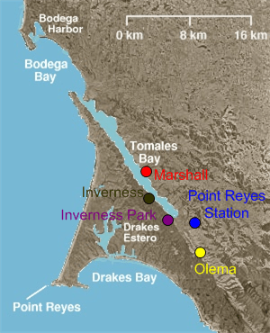
Point Reyes Station is located at 38°04′09″N 122°48′25″W / 38.06917°N 122.80694°W,[4] just south and east of the southern end of Tomales Bay, and slightly east of the San Andreas Fault just before the fault submerges down the center of Tomales Bay.
Formerly an actual port and railway terminus, Point Reyes Station, CA nominally borders Tomales Bay; the introduction of European cattle and planting of European grass seed on the natural hills caused destructive erosion and a combination of small dirt dams, silting, and intentional landfill for farming raised the level of former salt marshes and has left Point Reyes Station approximately 0.8-mile (1.3 km) from the nearest tidal flats, and that after expenditure of millions of dollars and recent efforts for reclamation of the natural environment.
The CDP has a total area of 3.62 sq mi (9.4 km2), all land.
History
Once land of the Coast Miwok Indians, Point Reyes Station gets its name from the nearby Point Reyes Peninsula (a major peninsula sticking out into the Pacific Ocean) and its status as a terminus stop on the North Pacific Coast Railroad connecting Cazadero to the Sausalito ferry.
Point Reyes Station is very close to the San Andreas Fault, which was responsible for the 1906 San Francisco earthquake. At one time, the epicenter of the quake was thought to be near Olema. A walking tour of the fault can be taken from the Point Reyes National Seashore's Visitor Center.
The place was called Olema Station when the railroad arrived in 1875.[5] The Point Reyes post office opened in 1882, changed its name to Marin in 1891, changed it back to Point Reyes later in 1891, and changed it to Point Reyes Station later in 1891.
Demographics
2010
The 2010 United States Census[6] reported that Point Reyes Station had a population of 848. The population density was 234.5 people per square mile (90.6/km²). The racial makeup of Point Reyes Station was 725 (85.5%) White, 7 (0.8%) African American, 3 (0.4%) Native American, 10 (1.2%) Asian, 73 (8.6%) from other races, and 30 (3.5%) from two or more races. Hispanic or Latino of any race were 155 persons (18.3%).
The Census reported that 100% of the population lived in households.
There were 412 households, out of which 87 (21.1%) had children under the age of 18 living in them, 168 (40.8%) were opposite-sex married couples living together, 19 (4.6%) had a female householder with no husband present, 21 (5.1%) had a male householder with no wife present. There were 19 (4.6%) unmarried opposite-sex partnerships, and 4 (1.0%) same-sex married couples or partnerships. 172 households (41.7%) were made up of individuals and 90 (21.8%) had someone living alone who was 65 years of age or older. The average household size was 2.06. There were 208 families (50.5% of all households); the average family size was 2.84.
The population was spread out with 155 people (18.3%) under the age of 18, 48 people (5.7%) aged 18 to 24, 152 people (17.9%) aged 25 to 44, 299 people (35.3%) aged 45 to 64, and 194 people (22.9%) who were 65 years of age or older. The median age was 51.1 years. For every 100 females, there were 81.2 males. For every 100 females age 18 and over, there were 81.4 males.
There were 490 housing units at an average density of 135.5 per square mile (52.3/km²), of which 50.2% were owner-occupied and 49.8% were occupied by renters. The homeowner vacancy rate was 0%; the rental vacancy rate was 6.8%. 50.6% of the population lived in owner-occupied housing units and 49.4% lived in rental housing units.
2000
As of the census[7] of 2000, there were 818 people, 352 households, and 218 families residing in the CDP. The population density was 225.1 people per square mile (87.0/km²). There were 373 housing units at an average density of 102.6 per square mile (39.7/km²). The racial makeup of the CDP in 2010 was 77.8% non-Hispanic White, 0.6% non-Hispanic African American, 1.1% Asian, and 2.2% from two or more races. Hispanic or Latino of any race were 18.3% of the population.
There were 352 households out of which 27.3% had children under the age of 18 living with them, 49.1% were married couples living together, 8.2% had a female householder with no husband present, and 37.8% were non-families. 29.8% of all households were made up of individuals and 13.6% had someone living alone who was 65 years of age or older. The average household size was 2.28 and the average family size was 2.83.
In the CDP, the population was spread out with 19.3% under the age of 18, 7.1% from 18 to 24, 23.1% from 25 to 44, 35.8% from 45 to 64, and 14.7% who were 65 years of age or older. The median age was 45 years. For every 100 females, there were 85.1 males. For every 100 females age 18 and over, there were 82.3 males.
The median income for a household in the CDP was $57,292, and the median income for a family was $69,821. Males had a median income of $41,181 versus $38,269 for females. The per capita income for the CDP was $39,339. About 6.0% of families and 6.6% of the population were below the poverty line, including none of those under age 18 and 15.5% of those age 65 or over.

Economy
A number of agricultural companies, many using organic and sustainable practices, are located there, including Cowgirl Creamery and Point Reyes Farmstead Cheese Company. Marin Organic operates out of the city.
See also
References
- 1 2 "Statewide Database". UC Regents. Retrieved December 31, 2014.
- ↑ "California's 2nd Congressional District - Representatives & District Map". Civic Impulse, LLC. Retrieved March 8, 2013.
- ↑ "2010 Census U.S. Gazetteer Files – Places – California". United States Census Bureau.
- 1 2 3 U.S. Geological Survey Geographic Names Information System: Point Reyes Station, California
- 1 2 3 Durham, David L. (1998). California's Geographic Names: A Gazetteer of Historic and Modern Names of the State. Clovis, Calif.: Word Dancer Press. p. 683. ISBN 1-884995-14-4.
- ↑ "2010 Census Interactive Population Search: CA - Point Reyes Station CDP". U.S. Census Bureau. Retrieved July 12, 2014.
- ↑ "American FactFinder". United States Census Bureau. Retrieved 2008-01-31.
External links
| Wikimedia Commons has media related to Point Reyes Station. |
- West Marin Citizen homepage
- The Point Reyes Light homepage
- Point Reyes Station Public Library
- KWMR - West Marin Public Radio

| Bodies of water |
|  |
|---|---|---|
| Counties | ||
| Major cities | ||
| Cities and towns 100k–250k | ||
| Cities and towns 50k–99k | ||
| Cities and towns 25k-50k | ||
| Cities and towns 10k–25k |
| |
| Sub-regions | ||