Manzanita, California
| Manzanita | |
|---|---|
| Unincorporated community | |
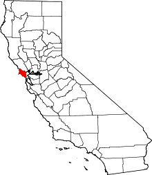
 Manzanita Location in California  Manzanita Manzanita (the US) | |
| Coordinates: 37°52′54″N 122°31′03″W / 37.88167°N 122.51750°WCoordinates: 37°52′54″N 122°31′03″W / 37.88167°N 122.51750°W | |
| Country | United States |
| State | California |
| County | Marin County |
| Elevation[1] | 16 ft (5 m) |
| Area codes | 415/628 |
Manzanita (formerly, Manza Waldo and Manzanita Junction) is an unincorporated community in Marin County, California.[1] Manzanita is also known as the Unincorporated Sausalito Houseboat Community.[2] It is located 6.25 miles (10 km) south of downtown San Rafael,[3] at an elevation of 16 feet (5 m).[1] It is located near Marin City.
The community is in area codes 415 and 628. The community was represented by Third District county supervisor Charles McGlashan until his death in May 2011, after which it has been represented by Kate Sears.[2][4] There are 400 floating dwellings in 5 marinas.[5] The community has a history of being the drug and sex mecca for Marin County, although that era has largely passed.[5]
References
- 1 2 3 U.S. Geological Survey Geographic Names Information System: Manzanita, California
- 1 2 District 3 Map, Mar County Board of Supervisors webpage, access date May 31, 2008
- ↑ Durham, David L. (1998). California's Geographic Names: A Gazetteer of Historic and Modern Names of the State. Clovis, Calif.: Word Dancer Press. p. 659. ISBN 1-884995-14-4.
- ↑ District 3 access date May 31, 2008
- 1 2 Floating through life / Sausalito houseboat community will show off its one-of-a-kind dwellings on Sunday, San Francisco Chronicle, by Kristine M. Carber, October 4, 2003, access date May 31, 2008
This article is issued from
Wikipedia.
The text is licensed under Creative Commons - Attribution - Sharealike.
Additional terms may apply for the media files.