Fairfax, California
| Town of Fairfax | |
|---|---|
| Town in California | |
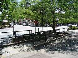 Downtown Fairfax (The Parkade) | |
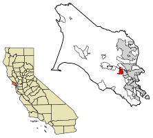 Location of Fairfax in Marin County, California. | |
 Fairfax Location in the United States  Fairfax Fairfax (the US) | |
| Coordinates: 37°59′14″N 122°35′20″W / 37.98722°N 122.58889°WCoordinates: 37°59′14″N 122°35′20″W / 37.98722°N 122.58889°W[1] | |
| Country |
|
| State |
|
| County | Marin |
| Incorporated | March 2, 1931[2] |
| Government | |
| • Town Council[3] |
Barbara Coler (Mayor) Renee Goddard (Vice-Mayor) David Weinsoff John Reed Peter Lacques |
| • County Board |
District 2 Katie Rice |
| • Town Manager | Judy Anderson |
| • Representation |
Sen. Mike McGuire (D) Asm. Marc Levine (D) Rep. Jared Huffman (D)[4] |
| Area[5] | |
| • Total | 2.20 sq mi (5.72 km2) |
| • Land | 2.20 sq mi (5.72 km2) |
| • Water | 0.00 sq mi (0.00 km2) 0% |
| Elevation[1] | 115 ft (35 m) |
| Population (2010) | |
| • Total | 7,441 |
| • Estimate (2016)[6] | 7,598 |
| • Density | 3,447.37/sq mi (1,331.33/km2) |
| Time zone | UTC-8 (PST) |
| • Summer (DST) | UTC-7 (PDT) |
| ZIP codes | 94930, 94978 |
| Area codes | 415/628 |
| FIPS code | 06-23168 |
| GNIS feature IDs | 277511, 2412609 |
| Website |
www |
Fairfax is an incorporated town in Marin County, California, United States. Fairfax is located 3.25 miles (5.2 km) west-northwest of San Rafael,[7] at an elevation of 115 feet (35 m).[1] The population is 7,441 at the 2010 census. Fairfax is the only town in America that holds a Green Party majority in the town council.
Geography
According to the United States Census Bureau, the town has a total area of 2.2 square miles (5.7 km2), all of it land. The geography of Fairfax consists mostly of hills and valleys.
Demographics
| Historical population | |||
|---|---|---|---|
| Census | Pop. | %± | |
| 1940 | 2,198 | — | |
| 1950 | 4,078 | 85.5% | |
| 1960 | 5,813 | 42.5% | |
| 1970 | 7,661 | 31.8% | |
| 1980 | 7,391 | −3.5% | |
| 1990 | 6,931 | −6.2% | |
| 2000 | 7,319 | 5.6% | |
| 2010 | 7,441 | 1.7% | |
| Est. 2016 | 7,598 | [6] | 2.1% |
| U.S. Decennial Census[8] | |||
2010
The 2010 United States Census[9] reported that Fairfax had a population of 7,441. The population density was 3,376.9 people per square mile (1,303.8/km²). The racial makeup of Fairfax was 6,617 (88.9%) White, 110 (1.5%) African American, 36 (0.5%) Native American, 204 (2.7%) Asian, 4 (0.1%) Pacific Islander, 174 (2.3%) from other races, and 296 (4.0%) from two or more races. Hispanic or Latino of any race were 504 persons (6.8%).
The Census reported that 7,419 people (99.7% of the population) lived in households, 12 (0.2%) lived in non-institutionalized group quarters, and 10 (0.1%) were institutionalized.
There were 3,379 households, out of which 939 (27.8%) had children under the age of 18 living in them, 1,422 (42.1%) were opposite-sex married couples living together, 319 (9.4%) had a female householder with no husband present, 134 (4.0%) had a male householder with no wife present. There were 267 (7.9%) unmarried opposite-sex partnerships, and 52 (1.5%) same-sex married couples or partnerships. 1,076 households (31.8%) were made up of individuals and 320 (9.5%) had someone living alone who was 65 years of age or older. The average household size was 2.20. There were 1,875 families (55.5% of all households); the average family size was 2.77.
The population was spread out with 1,436 people (19.3%) under the age of 18, 342 people (4.6%) aged 18 to 24, 1,806 people (24.3%) aged 25 to 44, 2,907 people (39.1%) aged 45 to 64, and 950 people (12.8%) who were 65 years of age or older. The median age was 45.9 years. For every 100 females, there were 94.2 males. For every 100 females age 18 and over, there were 92.9 males.
There were 3,585 housing units at an average density of 1,626.9 per square mile (628.2/km²), of which 2,103 (62.2%) were owner-occupied, and 1,276 (37.8%) were occupied by renters. The homeowner vacancy rate was 0.9%; the rental vacancy rate was 4.9%. 4,917 people (66.1% of the population) lived in owner-occupied housing units and 2,502 people (33.6%) lived in rental housing units.
2000
As of the census[10] of 2000, there were 7,319 people, 3,306 households, and 1,811 families residing in the town. The population density was 3,441.2 people per square mile (1,326.7/km²). There were 3,418 housing units at an average density of 1,607.0 per square mile (619.6/km²). The racial makeup of the town in 2010 was 85.4% non-Hispanic White, 1.4% non-Hispanic Black or African American, 0.3% Native American, 2.7% Asian, 0.1% Pacific Islander, 0.4% from other races, and 3.1% from two or more races. 6.8% of the population were Hispanic or Latino of any race.
There were 3,306 households out of which 27.4% had children under the age of 18 living with them, 41.2% were married couples living together, 10.0% had a female householder with no husband present, and 45.2% were non-families. 31.1% of all households were made up of individuals and 7.4% had someone living alone who was 65 years of age or older. The average household size was 2.20 and the average family size was 2.76.
In the town the population was spread out with 19.2% under the age of 18, 4.7% from 18 to 24, 33.5% from 25 to 44, 33.1% from 45 to 64, and 9.5% who were 65 years of age or older. The median age was 42 years. For every 100 females, there were 91.9 males. For every 100 females age 18 and over, there were 89.2 males.
The median income for a household in the town was $58,465, and the median income for a family was $68,308. Males had a median income of $51,457 versus $40,815 for females. The per capita income for the town was $34,080. About 4.3% of families and 6.5% of the population were below the poverty line, including 6.6% of those under age 18 and 7.6% of those age 65 or over.
Environmental factors
Soils in the Fairfax area mostly belong to the Tocaloma Series as classified by the U.S. Soil Conservation Service.[11] These soils consist of moderately deep, well drained soils on uplands. These soils are typically formed from sandstone and shale and often occur on slopes ranging above 15 percent.
History
The Coast Miwok Native Americans occupied stretches along local creeks, spring and seep areas; moreover prehistoric habitations were usually chosen near permanent and seasonal drainages, typically along flat ridges and terraces.
The first post office opened in 1910.[7] Fairfax became an incorporated town in 1931.[7] The town was named for Lord Charles Snowden Fairfax.[7]
Fairfax was the site of the last political duel in California, in 1861. Daniel Showalter and Charles W. Piercy, both former assemblymen in the state legislature[12] , decided to settle a political dispute at the home of Lord Fairfax, a mutual friend of both. Although Fairfax provided lunch to both men and tried to talk them out of it, they eventually headed to an open field nearby and dueled, with Showalter killing Piercy.[13]
On May 16, 1946 a B-17 Flying Fortress bomber, crashed on White's Hill just west of Fairfax.
Culture
In the mid-1960s, a softball game between Jefferson Airplane and the Grateful Dead took place at Central Field (also known as Contratti Park), a public downtown baseball field.[14][15][16]
Irving Berlin used to serenade from a treetop piano at Pastori's Hotel, formerly Bird's Nest Glen, the home of Lord Charles Snowden Fairfax, and later known as the Marin Town & Country Club.[17]
Politics
In 2017, Fairfax had 5,602 registered voters. Of those, 3,726 (66.5%) are registered Democrats, 370 (6.6%) are registered Republicans, 1,528 (27.3%) have declined to state a political party and 155 (2.8%) are registered with the Green Party.[18]
Notable people
References
- 1 2 3 "Fairfax". Geographic Names Information System. United States Geological Survey.
- ↑ "California Cities by Incorporation Date". California Association of Local Agency Formation Commissions. Archived from the original (Word) on November 3, 2014. Retrieved August 25, 2014.
- ↑ "Town of Fairfax, California - Website". Retrieved April 6, 2015.
- ↑ "California's 2nd Congressional District - Representatives & District Map". Civic Impulse, LLC. Retrieved March 8, 2013.
- ↑ "2016 U.S. Gazetteer Files". United States Census Bureau. Retrieved Jul 19, 2017.
- 1 2 "Population and Housing Unit Estimates". Retrieved June 9, 2017.
- 1 2 3 4 Durham, David L. (1998). California's Geographic Names: A Gazetteer of Historic and Modern Names of the State. Clovis, Calif.: Word Dancer Press. p. 631. ISBN 1-884995-14-4.
- ↑ "Census of Population and Housing". Census.gov. Archived from the original on May 12, 2015. Retrieved June 4, 2015.
- ↑ "2010 Census Interactive Population Search: CA - Fairfax town". U.S. Census Bureau. Retrieved July 12, 2014.
- ↑ "American FactFinder". United States Census Bureau. Archived from the original on September 11, 2013. Retrieved 2008-01-31.
- ↑ Environmental Impact Report for the Groza-Erickson Property, Ridgeway Avenue, Fairfax, California, Earth Metrics Inc, prepared for the State of California Environmental Clearinghowe drink loys of beeruse, Sacramento, Ca., January, 1989
- ↑ , accessed July 18, 2009
- ↑ , accessed July 18, 2009
- ↑ Rex Radio, January 1991, transcript of discussion with David Grisman and Jerry Garcia Archived January 22, 2009, at the Wayback Machine., accessed February 5, 2008
- ↑ James Sullivan, San Francisco Chronicle, October 2, 2001, "Dawg days: David Grisman's daughter makes film about his bluegrass partnership with Garcia", accessed February 5, 2008
- ↑ "The Story of "Ripple" by the Grateful Dead", accessed May 16, 2015
- ↑ William Sager, Fairfax (Images of America), Arcadis Publishing, 2006 ISBN 0-7385-3090-5, accessed February 5, 2008
- ↑ http://elections.cdn.sos.ca.gov/ror/ror-pages/ror-odd-year-2017/politicalsub.pdf
External links
| Wikimedia Commons has media related to Fairfax, California. |
- Official website

- Fairfax Library
- Fairfax Historical Society
- Marin Town & Country Club
- Sustainable Fairfax
| Bodies of water |
|  |
|---|---|---|
| Counties | ||
| Major cities | ||
| Cities and towns 100k–250k | ||
| Cities and towns 50k–99k | ||
| Cities and towns 25k-50k | ||
| Cities and towns 10k–25k |
| |
| Sub-regions | ||