Penne-d'Agenais
| Penne-d'Agenais | ||
|---|---|---|
| Commune | ||
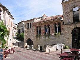 A view within Penne-d'Agenais | ||
| ||
 Penne-d'Agenais Location within Nouvelle-Aquitaine region  Penne-d'Agenais | ||
| Coordinates: 44°23′23″N 0°49′11″E / 44.3897°N 0.8197°ECoordinates: 44°23′23″N 0°49′11″E / 44.3897°N 0.8197°E | ||
| Country | France | |
| Region | Nouvelle-Aquitaine | |
| Department | Lot-et-Garonne | |
| Arrondissement | Villeneuve-sur-Lot | |
| Canton | Le Pays de Serres | |
| Intercommunality | Communauté de communes du canton de Penne-d'Agenais | |
| Government | ||
| • Mayor (2008–2014) | Arnaud Devillier | |
| Area1 | 46.71 km2 (18.03 sq mi) | |
| Population (1999)2 | 2,330 | |
| • Density | 50/km2 (130/sq mi) | |
| Time zone | UTC+1 (CET) | |
| • Summer (DST) | UTC+2 (CEST) | |
| INSEE/Postal code | 47203 /47140 | |
| Elevation |
52–231 m (171–758 ft) (avg. 210 m or 690 ft) | |
|
1 French Land Register data, which excludes lakes, ponds, glaciers > 1 km2 (0.386 sq mi or 247 acres) and river estuaries. 2 Population without double counting: residents of multiple communes (e.g., students and military personnel) only counted once. | ||
.svg.png)
Penne-d'Agenais (Languedocien: Pena d’Agenés) is a commune in the Lot-et-Garonne department in south-western France.
See also
| Wikimedia Commons has media related to Penne-d'Agenais. |
This article is issued from
Wikipedia.
The text is licensed under Creative Commons - Attribution - Sharealike.
Additional terms may apply for the media files.