Alpine, California
| Alpine | |
|---|---|
| Census-designated place | |
.jpg) | |
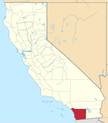
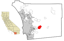 Location in San Diego County and the state of California | |
 Alpine Location in the United States | |
| Coordinates: 32°50′4″N 116°46′14″W / 32.83444°N 116.77056°WCoordinates: 32°50′4″N 116°46′14″W / 32.83444°N 116.77056°W | |
| Country |
|
| State |
|
| County | San Diego |
| Area[1] | |
| • Total | 26.79 sq mi (69.37 km2) |
| • Land | 26.78 sq mi (69.37 km2) |
| • Water | 0.00 sq mi (0.00 km2) 0.01% |
| Elevation[2] | 1,834 ft (559 m) |
| Population (2010) | |
| • Total | 8,592 |
| • Estimate (2016)[3] | N/A |
| Time zone | UTC-8 (PST) |
| • Summer (DST) | UTC-7 (PDT) |
| ZIP codes | 91901, 91903 |
| Area code | 619 |
| FIPS code | 06-01192 |
| GNIS feature IDs | 1660247, 2407726 |
Alpine is a census-designated place (CDP) in the Cuyamaca Mountains of San Diego County, California. Alpine had a population of 14,236 at the 2010 census, up from 13,143 at the 2000 census. The town is largely surrounded by the Cleveland National Forest and borders two reservations of the Kumeyaay Nation, Viejas and Sycuan, and the rural unincorporated areas of the city of El Cajon.
History
The community's name was suggested by a resident in the 1880s who said that the environment reminded her of her native country of Switzerland.[4]
The small commercial district along Alpine Blvd. has seen some suburban development in recent decades, and it is surrounded by large stretches of less densely populated rural areas that began in the late 19th and early 20th century. Horse ranches and small farms are still common, along with open chaparral hillsides and riparian canyons.
Before its modern settlement, the area was part of the home of the Kumeyaay Indians, whose ancestors had lived here possibly as long as 12,000 years.
Geography
It sits on both sides of Interstate 8 at the eastern extent of the California coastal region and the western extent of the Peninsular Ranges, about 30 miles from downtown San Diego, at an altitude of about 2,000 feet.
The location of Alpine is not precisely defined since it is an unincorporated area. According to the United States Geological Survey, it is at 32°50′6″N 116°45′59″W / 32.83500°N 116.76639°W (32.8350521, -116.7664109),[5] which is near the intersection of Alpine Boulevard and Tavern Road. That is approximately where most maps place Alpine. Kumeyaay tribes are indigenous to the area, and the Ewiiaapaayp Band and Viejas Band of Kumeyaay Indians both have headquarters in Alpine.[6]
According to the United States Census Bureau, it is at 32°50′4″N 116°46′14″W / 32.83444°N 116.77056°W (32.834563, -116.770615).[7] That is approximately 1,200 feet (370 m) west of the USGS location. According to the United States Census Bureau, the CDP has a total area of 26.8 square miles (69 km2), 99.99% land and 0.01% water.
Viejas Mountain is the highest peak in the area, at 4,189 feet.
Climate
According to the Köppen Climate Classification system, Alpine has a warm-summer Mediterranean climate, abbreviated "Csa" on climate maps.[8] Summers are warm and dry, and winters are cool with moderate precipitation. Temperatures are more extreme than coastal San Diego, similar to nearby El Cajon and Ramona, and less extreme than the nearby mountain and desert regions, such as Julian.
Rainfall averages less than 15 inches per year, falling mostly from November to March, with numerous microclimates and annual variation. Rainfall amounts can vary greatly from month to month, or from year to year.
Average January temperatures range from the low 60s in the day to the low 40s at night. Average July temperatures range from upper 80s to the low 90s in the day to the low 60s at night. Highs of over 105 in the summer and lows of under 35 in the winter are occasional, particularly in the northern section of Alpine, on the slopes of Viejas Mountain.
Snowfall is very rare within the town of Alpine, with trace amounts falling once out of every 2 to 3 winters. However, light snow commonly falls each winter on elevations above 3,000 feet.
Demographics
| Historical population | |||
|---|---|---|---|
| Census | Pop. | %± | |
| U.S. Decennial Census[9] | |||
2010
The 2010 United States Census[10] reported that Alpine had a population of 14,236. The population density was 531.5 people per square mile (205.2/km²). The racial makeup of Alpine was 12,424 (87.3%) White, 167 (1.2%) African American, 222 (1.6%) Native American, 319 (2.2%) Asian, 39 (0.3%) Pacific Islander, 576 (4.0%) from other races, and 489 (3.4%) from two or more races. Hispanic or Latino of any race were 2,081 persons (14.6%).
The Census reported that 14,098 people (99.0% of the population) lived in households, 136 (1.0%) lived in non-institutionalized group quarters, and 2 (0%) were institutionalized.
There were 5,248 households, out of which 1,932 (36.8%) had children under the age of 18 living in them, 3,120 (59.5%) were opposite-sex married couples living together, 515 (9.8%) had a female householder with no husband present, 268 (5.1%) had a male householder with no wife present. There were 283 (5.4%) unmarried opposite-sex partnerships, and 39 (0.7%) same-sex married couples or partnerships. 1,048 households (20.0%) were made up of individuals and 433 (8.3%) had someone living alone who was 65 years of age or older. The average household size was 2.69. There were 3,903 families (74.4% of all households); the average family size was 3.09.
The population was spread out with 3,403 people (23.9%) under the age of 18, 1,164 people (8.2%) aged 18 to 24, 3,133 people (22.0%) aged 25 to 44, 4,583 people (32.2%) aged 45 to 64, and 1,953 people (13.7%) who were 65 years of age or older. The median age was 41.9 years. For every 100 females, there were 97.8 males. For every 100 females age 18 and over, there were 94.6 males.
There were 5,536 housing units at an average density of 206.7 per square mile (79.8/km²), of which 3,597 (68.5%) were owner-occupied, and 1,651 (31.5%) were occupied by renters. The homeowner vacancy rate was 2.0%; the rental vacancy rate was 6.3%. 9,935 people (69.8% of the population) lived in owner-occupied housing units and 4,163 people (29.2%) lived in rental housing units.
2000
As of the census[11] of 2000, there were 13,143 people, 4,775 households, and 3,652 families residing in the CDP. The population density was 489.1 inhabitants per square mile (188.9/km²). There were 4,958 housing units at an average density of 184.5 per square mile (71.2/km²). The racial makeup of the CDP was 90.8% White, 0.8% African American, 1.2% Native American, 2.0% Asian, 0.2% Pacific Islander, 2.9% from other races, and 2.2% from two or more races. 10.2% of the population were Hispanic (U.S. Census) or Latino of any race.
There were 4,775 households out of which 36.5% had children under the age of 18 living with them, 63.5% were married couples living together, 8.5% had a female householder with no husband present, and 23.5% were non-families. 17.3% of all households were made up of individuals and 7.0% had someone living alone who was 65 years of age or older. The average household size was 2.72 and the average family size was 3.06.
In the CDP, the population was spread out with 26.0% under the age of 18, 7.0% from 18 to 24, 29.3% from 25 to 44, 26.6% from 45 to 64, and 11.1% who were 65 years of age or older. The median age was 38 years. For every 100 females, there were 99.9 males. For every 100 females age 18 and over, there were 97.6 males.
The median income for a household in the CDP was $61,832, and the median income for a family was $69,821. Males had a median income of $51,444 versus $31,891 for females. The per capita income for the CDP was $29,523. About 4.9% of families and 6.6% of the population were below the poverty line, including 9.6% of those under age 18 and 4.3% of those age 65 or over.
Government
In the California State Legislature Alpine is in the 38th Senate District, represented by Republican Joel Anderson, and in the 71st Assembly District, represented by Republican Randy Voepel.[12]
In the United States House of Representatives, Alpine is in California's 50th congressional district, represented by Republican Duncan D. Hunter.[13]
Notable people
- Being as an Ocean, melodic hardcore band
- Sheldon Creed, off-road racing driver
- Marcus Giles, former Major League Baseball second baseman
- Mark Grant, former Major league baseball pitcher and current San Diego Padres announcer
- Duncan Hunter, United States Representative
- Cole Whitt, NASCAR driver
References
- ↑ "2016 U.S. Gazetteer Files". United States Census Bureau. Retrieved Jul 19, 2017.
- ↑ "Alpine". Geographic Names Information System. United States Geological Survey. Retrieved October 18, 2014.
- ↑ "Population and Housing Unit Estimates". Retrieved June 9, 2017.
- ↑ William Bright; Erwin Gustav Gudde (November 30, 1998). 1500 California place names: their origin and meaning. University of California Press. p. 14. ISBN 978-0-520-21271-8. Retrieved January 20, 2012.
- ↑ "Geographic Names Information System". United States Geological Survey. Retrieved 2008-01-31.
- ↑ "Tribal Governments by Area." Archived May 5, 2010, at the Wayback Machine. National Congress of American Indians. (retrieved 5 June 2010)
- ↑ "US Gazetteer files: 2010, 2000, and 1990". United States Census Bureau. 2011-02-12. Retrieved 2011-04-23.
- ↑ Climate Summary for Alpine, California
- ↑ "Census of Population and Housing". Census.gov. Retrieved June 4, 2016.
- ↑ "2010 Census Interactive Population Search: CA - Alpine CDP". U.S. Census Bureau. Retrieved July 12, 2014.
- ↑ "American FactFinder". United States Census Bureau. Archived from the original on September 11, 2013. Retrieved 2008-01-31.
- ↑ "Statewide Database". UC Regents. Retrieved December 8, 2014.
- ↑ "California's 50th Congressional District - Representatives & District Map". Civic Impulse, LLC.
External links
| Wikimedia Commons has media related to Alpine, California. |
- Alpine Mountain Empire Chamber of Commerce
- The Alpine Sun - local newspaper