La Mesa, California
| La Mesa, California | ||
|---|---|---|
| City in California | ||
| City of La Mesa | ||
| ||
| Motto(s): "Jewel of the Hills"[1] | ||
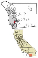 Location of La Mesa in San Diego County, California. | ||
 La Mesa, California Location in the United States | ||
| Coordinates: 32°46′17″N 117°1′22″W / 32.77139°N 117.02278°WCoordinates: 32°46′17″N 117°1′22″W / 32.77139°N 117.02278°W | ||
| Country |
| |
| State |
| |
| County |
| |
| Incorporated | February 16, 1912[2] | |
| Government | ||
| • Type | Council / manager[3] | |
| • Mayor | Mark Arapostathis[4] | |
| • Vice mayor | Guy McWhirter[4] | |
| • Councilmember | Bill Baber[4] | |
| • Councilmember | Kristine C. Alessio[4] | |
| • Councilmember | Colin Parent[4] | |
| Area[5] | ||
| • Total | 9.10 sq mi (23.58 km2) | |
| • Land | 9.09 sq mi (23.55 km2) | |
| • Water | 0.01 sq mi (0.03 km2) 0.44% | |
| Elevation[6] | 528 ft (161 m) | |
| Population (2010)[7] | ||
| • Total | 57,065 | |
| • Estimate (2016)[8] | 59,948 | |
| • Density | 6,592.04/sq mi (2,545.32/km2) | |
| Time zone | UTC−8 (Pacific) | |
| • Summer (DST) | UTC−7 (PDT) | |
| ZIP codes | 91941–91944 | |
| Area code | 619 | |
| FIPS code | 06-40004 | |
| GNIS feature IDs | 1660859, 2411576 | |
| Website |
cityoflamesa | |
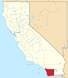
La Mesa is a city in Southern California, located 9 miles (14 km) east of Downtown San Diego in San Diego County. The population was 57,065 at the 2010 census, up from 54,749 at the 2000 census. Its civic motto is "the Jewel of the Hills."
History
La Mesa in Spanish means "the table", or alternately "the plateau", relating to its geography.[9] La Mesa was part of a larger tract, Mission San Diego de Alcalá, and was used by Spanish Missionaries.[10]
La Mesa was founded in 1869 and The City of La Mesa was incorporated on February 16, 1912, under the general laws of the state of California. As such, it does not have a city charter but operates under the laws of the state of California in all respects not specifically covered by any city ordinance.
Its official flower is the bougainvillea.[1]
Geography
La Mesa is located at 32°46′17″N 117°1′22″W / 32.77139°N 117.02278°W (32.771450, -117.022797).[11] It is bordered by the city of San Diego on the west and north, Spring Valley and Lemon Grove on the south, and El Cajon on the east. It includes the neighborhood of Grossmont.
According to the United States Census Bureau, the city has a total area of 9.1 square miles (24 km2). 9.1 square miles (24 km2) of it is land and 0.04 square miles (0.10 km2) of it (0.44%) is water.
Climate
La Mesa is approximately 12 mi (19 km)) east of the Pacific Ocean. Because of this, La Mesa typically experiences more extreme temperatures than San Diego, which mostly lies significantly closer to the Pacific Ocean. La Mesa has a Semi-arid Steppe climate. La Mesa typically has hot, dry summers and warm winters with most of the annual precipitation falling between November and March. The city has dry weather with around 13" of annual precipitation. Summer temperatures are generally hot, with average highs of 78 °F-92 °F (26 °C–33 °C) and lows of 56 °F–68 °F (13 °C–20 °C). Winter temperatures are warm, with average high temperatures of 66 °F–77 °F (19 °C–25 °C) and lows of 46 °F–58 °F (8 °C–14 °C).
The climate in the San Diego area, like much of California, often varies significantly over short geographical distances resulting in micro-climates. In San Diego's case, this is mainly due to the city's topography (the Bay, and the numerous hills, mountains, and canyons). Frequently, particularly during the "May gray/June gloom" period, a thick "marine layer" cloud cover will keep the air cool and damp within a few miles of the coast, but will yield to bright cloudless sunshine approximately 5–10 miles (8–16 km) inland. This happens every year in May and June. Even in the absence of June gloom, inland areas tend to experience higher temperatures than areas closer to the coast.
| Climate data for La Mesa, California | |||||||||||||
|---|---|---|---|---|---|---|---|---|---|---|---|---|---|
| Month | Jan | Feb | Mar | Apr | May | Jun | Jul | Aug | Sep | Oct | Nov | Dec | Year |
| Record high °F (°C) | 90 (32) |
92 (33) |
96 (36) |
105 (41) |
100 (38) |
103 (39) |
106 (41) |
106 (41) |
109 (43) |
105 (41) |
97 (36) |
91 (33) |
109 (43) |
| Average high °F (°C) | 67.0 (19.4) |
68.4 (20.2) |
68.8 (20.4) |
71.6 (22) |
73.3 (22.9) |
77.5 (25.3) |
82.8 (28.2) |
84.3 (29.1) |
83.3 (28.5) |
78.8 (26) |
73.1 (22.8) |
68.3 (20.2) |
74.8 (23.8) |
| Average low °F (°C) | 44.5 (6.9) |
46.0 (7.8) |
47.6 (8.7) |
50.6 (10.3) |
54.3 (12.4) |
57.7 (14.3) |
61.5 (16.4) |
62.8 (17.1) |
61.0 (16.1) |
55.9 (13.3) |
49.2 (9.6) |
44.8 (7.1) |
53 (11.7) |
| Record low °F (°C) | 26 (−3) |
31 (−1) |
34 (1) |
31 (−1) |
41 (5) |
47 (8) |
46 (8) |
49 (9) |
45 (7) |
30 (−1) |
30 (−1) |
29 (−2) |
26 (−3) |
| Average precipitation inches (mm) | 2.62 (66.5) |
2.17 (55.1) |
2.42 (61.5) |
1.05 (26.7) |
0.31 (7.9) |
0.08 (2) |
0.05 (1.3) |
0.08 (2) |
0.21 (5.3) |
0.54 (13.7) |
1.42 (36.1) |
1.55 (39.4) |
12.5 (317.5) |
| Source: WRCC, Period of Record General Climate Summary Table[12] | |||||||||||||
Transportation
The City of La Mesa is served by the San Diego Trolley's Orange Line at its stations in Spring Street, La Mesa Boulevard, Grossmont Transit Center, and Amaya Drive, the last two of which are also served by the Green Line.
By car, the city is served by Interstate 8, California State Route 94, and California State Route 125.
Demographics
| Historical population | |||
|---|---|---|---|
| Census | Pop. | %± | |
| 1920 | 1,004 | — | |
| 1930 | 2,513 | 150.3% | |
| 1940 | 3,925 | 56.2% | |
| 1950 | 10,946 | 178.9% | |
| 1960 | 30,441 | 178.1% | |
| 1970 | 39,178 | 28.7% | |
| 1980 | 50,308 | 28.4% | |
| 1990 | 52,931 | 5.2% | |
| 2000 | 54,749 | 3.4% | |
| 2010 | 57,065 | 4.2% | |
| Est. 2016 | 59,948 | [8] | 5.1% |
| U.S. Decennial Census[13] | |||
2010
The 2010 United States Census[14] reported that La Mesa had a population of 57,065. The population density was 6,259.6 people per square mile (2,416.8/km²). The racial makeup of La Mesa was 54.1% White, Hispanic or Latino of any race was 21.5%, 8.0% African American, 5.8% Asian, 0.8% Native American, 0.6% Pacific Islander, 11.6% from other races, and 5.8% from two or more races.
The Census reported that 56,408 people (98.8% of the population) lived in households, 124 (0.2%) lived in non-institutionalized group quarters, and 533 (0.9%) were institutionalized.
There were 24,512 households, out of which 6,695 (27.3%) had children under the age of 18 living in them, 9,330 (38.1%) were opposite-sex married couples living together, 3,102 (12.7%) had a female householder with no husband present, 1,335 (5.4%) had a male householder with no wife present. There were 1,731 (7.1%) unmarried opposite-sex partnerships, and 243 (1.0%) same-sex married couples or partnerships. 8,004 households (32.7%) were made up of individuals and 2,924 (11.9%) had someone living alone who was 65 years of age or older. The average household size was 2.30. There were 13,767 families (56.2% of all households); the average family size was 2.94.
The population was spread out with 11,164 people (19.6%) under the age of 18, 6,396 people (11.2%) aged 18 to 24, 16,792 people (29.4%) aged 25 to 44, 14,625 people (25.6%) aged 45 to 64, and 8,088 people (14.2%) who were 65 years of age or older. The median age was 37.1 years. For every 100 females, there were 90.8 males. For every 100 females age 18 and over, there were 88.1 males.
There were 26,167 housing units at an average density of 2,870.3 per square mile (1,108.2/km²), of which 11,221 (45.8%) were owner-occupied, and 13,291 (54.2%) were occupied by renters. The homeowner vacancy rate was 1.4%; the rental vacancy rate was 7.2%. 26,713 people (46.8% of the population) lived in owner-occupied housing units and 29,695 people (52.0%) lived in rental housing units.
2000
As of the census[15] of 2000, there were 54,749 people, 24,186 households, and 13,374 families residing in the city. The population density was 5,909.9 inhabitants per square mile (2,282.8/km²). There were 24,943 housing units at an average density of 2,692.5 per square mile (1,040.0/km²). The racial makeup of the city was 51.0% White, 6.7% African American, 0.6% Native American, 5.5% Asian, 0.4% Pacific Islander, 9.5% from other races, and 4.3% from two or more races. Hispanic or Latino of any race were 26.6% of the population.
There were 24,186 households out of which 24.7% had children under the age of 18 living with them, 39.8% were married couples living together, 11.6% had a female householder with no husband present, and 44.7% were non-families. 34.2% of all households were made up of individuals and 12.9% had someone living alone who was 65 years of age or older. The average household size was 2.22 and the average family size was 2.86.
In the city, the population was spread out with 19.8% under the age of 18, 9.9% from 18 to 24, 32.9% from 25 to 44, 20.3% from 45 to 64, and 17.0% who were 65 years of age or older. The median age was 37 years. For every 100 females, there were 89.3 males. For every 100 females age 18 and over, there were 86.2 males.
The median income for a household in the city was $41,693, and the median income for a family was $50,398. Males had a median income of $37,215 versus $30,413 for females. The per capita income for the city was $22,372. About 5.2% of families and 9.4% of the population were below the poverty line, including 10.4% of those under age 18 and 6.2% of those age 65 or over.
Current estimates
According to estimates by the San Diego Association of Governments (not adjusted for inflation). When adjusted for inflation (1999 dollars; comparable to Census data above), the median household income was $45,156.
Arts and culture
Farmer's Market
There is a Farmer's Market in La Mesa Village every Friday afternoon.[16]
Flag Day Parade
On June 14, 1997, with the help of Councilmember Ruth Sterling, the City of La Mesa inaugurated its First Annual Flag Day Parade.[17]
La Mesa Walkway of the Stars
The “Walkway of the Stars” is a pedestrian walkway that has been transformed into an urban park in downtown La Mesa. The vision for a place to recognize La Mesa's extraordinary volunteers was provided by Councilmember Ruth Sterling. The park’s theme honors the city’s outstanding volunteers who have provided 10,000 or more hours of service to the city of La Mesa. “Walkway of the Stars” is located between the Allison Avenue municipal parking lot and La Mesa Boulevard.[18]
Oktoberfest
At the beginning of each October, La Mesa holds its biggest event of the year, Oktoberfest, attended by approximately 200,000 people over the three nights of the event.[19]
Back to the 50s Car Show
The Back to the '50s Car Show is an annual summer event where classic car enthusiasts come to display their vehicles. The event is held every Thursday evening during the months of June through August in La Mesa Village along La Mesa Boulevard. Admission to the event is free.[20]
Sundays At Six
Sundays At Six is a free concert series that is offered every year in the months of June and July. For 6 Sundays free concerts are performed in Harry Griffen Park from 6pm - 7pm. The concerts began in 2002. Sundays @ 6 was conceived by Mayor Mark Arapostathis.
Other events
Other annual events include Christmas in the Village, and Antique Street Fair.[21]
Grossmont Center
The city's major mall, Grossmont Center, opened in 1961.[22]
Government
City government
La Mesa is a general law city which uses a council-manager system of government with a directly-elected mayor. The city council consists of a mayor and four councilmembers, all of whom are elected from the city at large and serve four-year terms. The council meets on the second and fourth Tuesday of each month.[3]
State and federal representation
In the California State Legislature, La Mesa is in the 38th Senate District, represented by Republican Joel Anderson, and in the 79th Assembly District, represented by Democrat Shirley Weber.[23]
In the United States House of Representatives, La Mesa is in California's 53rd congressional district, represented by Democrat Susan Davis.[24]
Education
The schools in La Mesa are operated by two districts. The La Mesa-Spring Valley School District operates most of the elementary and middle schools in the city, while the Grossmont Union High School District operates Helix High School and the Gateway day schools.
Elementary schools
- Rolando Elementary School (La Mesa-Spring Valley School District)
- La Mesa Dale Elementary School (La Mesa-Spring Valley School District)
- Maryland Avenue Elementary School (La Mesa-Spring Valley School District)
- RHR DFAF Private Charter School
- Murdock Elementary School (La Mesa-Spring Valley School District)
- Murray Manor Elementary School (La Mesa-Spring Valley School District)
- Northmont Elementary School (La Mesa-Spring Valley School District)
- Lemon Avenue Elementary School (La Mesa-Spring Valley School District)
- Vista La Mesa Academy (Lemon Grove School District)
- St. Martin's Academy (private)
- Liberty Charter School (private)
- San Diego Jewish Academy (private)
- Christ Lutheran School (private)
- Innovation Center La Mesa – Julian Charter School (charter)
- La Mesa Arts Academy (4th - 8th Grade) - La Mesa-Spring Valley School District
Middle/junior high schools
- Parkway Middle School (La Mesa-Spring Valley School District)
- La Mesa Arts Academy (4-8 Grade) (LMAAC) (La Mesa-Spring Valley School District)
- Vista La Mesa Academy (Lemon Grove School District)
High schools
- Helix High School (Grossmont Union High School District)
- Grossmont High School (Grossmont Union High School District) includes some students from La Mesa while having an El Cajon street address
K through 12
- Gateway Community Day (Grossmont Union High School District)
- Gateway West Community Day (Grossmont Union High School District)
- Mt. Helix Academy (Private Administration)
Notable people
- Aaron Boone, baseball player
- Brooks Conrad, baseball player
- Ralph Drollinger, basketball player and religious minister
- Dennis Hopper, actor/producer/photographer
- Dave Mustaine, founding guitarist/vocalist of Megadeth
- Willie O'Ree, hockey player
- Steve Roach, ambient musician
- Claudia Sandoval, MasterChef winner
- Cathy Scott, true-crime author
- Eddie Vedder, vocalist/guitarist of Pearl Jam
- Bill Walton, basketball player and sportscaster
- Ellen Ochoa, engineer and astronaut
References
- 1 2 "La Mesa Fast Facts". City of La Mesa California. Archived from the original on June 10, 2014. Retrieved June 9, 2014.
- ↑ "California Cities by Incorporation Date". California Association of Local Agency Formation Commissions. Archived from the original (Word) on November 3, 2014. Retrieved August 25, 2014.
- 1 2 "City Council". La Mesa, CA. Retrieved February 19, 2015.
- 1 2 3 4 5 "City Council". La Mesa, CA. Retrieved February 19, 2015.
- ↑ "2016 U.S. Gazetteer Files". United States Census Bureau. Retrieved Jul 19, 2017.
- ↑ "La Mesa". Geographic Names Information System. United States Geological Survey. Retrieved October 22, 2014.
- ↑ "La Mesa (city) QuickFacts". United States Census Bureau. Archived from the original on August 22, 2012. Retrieved April 18, 2015.
- 1 2 "Population and Housing Unit Estimates". Retrieved June 9, 2017.
- ↑ "Profile for La Mesa, California, CA". ePodunk. Retrieved September 12, 2012.
- ↑ City of La Mesa history Archived July 6, 2007, at the Wayback Machine.
- ↑ "US Gazetteer files: 2010, 2000, and 1990". United States Census Bureau. 2011-02-12. Retrieved 2011-04-23.
- ↑ "LA MESA, CALIFORNIA". Western Regional Climate Center. Retrieved 2016-02-09.
- ↑ "Census of Population and Housing". Census.gov. Retrieved June 4, 2015.
- ↑ "2010 Census Interactive Population Search: CA - La Mesa city". U.S. Census Bureau. Retrieved July 12, 2014.
- ↑ "American FactFinder". United States Census Bureau. Retrieved 2008-01-31.
- ↑ La Mesa, CA - Official Website - Farmer's Market
- ↑ "Ruth Sterling". City of La Mesa. Archived from the original on June 10, 2014. Retrieved June 9, 2014.
- ↑ La Mesa, CA - Official Website
- ↑ Oktoberfest website
- ↑ "La Mesa Car Show".
- ↑ La Mesa Village Merchants Association
- ↑ Engstrand, Iris Wilson (2005). San Diego: California's Cornerstone. Sunbelt Publications. p. 172.
- ↑ "Statewide Database". UC Regents. Retrieved December 6, 2014.
- ↑ "California's 53rd Congressional District - Representatives & District Map". Civic Impulse, LLC.
External links
| Wikimedia Commons has media related to La Mesa, California. |
| Counties | ||
|---|---|---|
| Major city | ||
| Cities 100k - 250k | ||
| Cities and towns 20k - 99k | ||
| CDPs 20k+ | ||
| Bodies of water | ||
| Regions | ||
| Parks and Monuments | ||