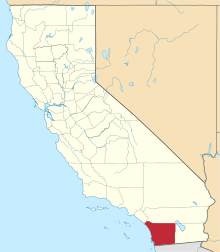
Campo Indian Reservation
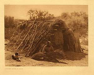 Kumeyaay woman in front of her traditional house at Campo, photo by Edward Curtis | |
| Total population | |
|---|---|
| 351 reservation residents[1] | |
| Regions with significant populations | |
|
| |
| Languages | |
| Kumeyaay,[2] Tipai[3] English | |
| Religion | |
|
Traditional tribal religion, Christianity (Roman Catholicism)[4] | |
| Related ethnic groups | |
|
other Kumeyaay people,[1][5] Cocopa, Quechan, Paipai, and Kiliwa |
The Campo Indian Reservation is home to the Campo Band of Diegueňo Mission Indians, also known as the Campo Kumeyaay Nation, a federally recognized tribe of Kumeyaay people in the southern Laguna Mountains, in eastern San Diego County, California.[3] The reservation was founded in 1893 and is 16,512 acres (66.82 km2).[1][2]
The reservation can be found "in the southeastern San Diego County atop the Laguna Mountains". Originally the location was set on 710 acres in 1893. Eighty additional acres were added in the winter of 1907, and another 13,610 acres were added in 1911. "All land on Campo is tribal-owned land; there are presently no allotments or assignments".[6]
History
Pre-Contact
The sovereign land of the Kumeyaay Nation ranged from the Northern outskirts of modern San Diego county to the western borders of the imperial valley and the northern tip of Baja California, Mexico. There were many clans of the Kumeyaay nation, one being the Campo. The multiple clans would join together when in combat with neighboring threats.[7]
Post-Contact
The Campo and their neighboring clans resisted the Spanish missionaries and soldiers. Notably, the Mission Basilica San Diego de Alcala, founded in 1769, proved to be troubling for the tribe and many revolts broke out. "The most famous of these was the attack and destruction of the San Diego Mission in 1775".[8]
After the Mexican Revolution, the new Mexican government enforced a secularization of the Mission system.[8] Most of the Missions became ranches where most Indian tribes of the region were forced to labor.In response multiple Indian revolts and raids in the region brought destruction to many of the Ranchos. "By 1842, the Ranchos had been abandoned and the warriors were attacking the last stronghold, the City of San Diego",[8] however the city was not destroyed.
The Mexican-American war intersects with the Kumeyaay when US forces made their way into San Diego. Although the Kumeyaay "offered allegiance", they were directed by US forces to stay out of the conflict. This interaction thus led to an agreed upon distinction of land in the Treaty of Santa Ysabel. However, this treaty was "voted down and placed under seal by the Senate of the United States".[8]
Through a combination of military conflicts, raid suppression, and migration brought by the gold rush: "population of Indians in California dropped by 90% from 1850 to 1860". And soon after 1870, the land of the Kumeyaay would begin to be divided and set into sections, thus defining the later reservations. "Further additions were taken into trust over the next 25 years including the first portion of the Campo Indian Reservation in 1893".[8]
Modern Era
In time the Treaty of Santa Ysabel, and many others of its kind, were revealed to have been kept in secrecy. In 1927, supporters of the Mission Indian Federation, a Riverside County organization in the support of Native rights,[9] came in conflict with the Bureau of Indian Affairs "police resulting in shootings and deaths on the Campo Indian Reservation".[10]
Later periods of the twentieth century proved to bring minor justices to the Campo Indian Reservation, including "1960s public assistance and food programs",[10] the Self Determination Act of 1975, and by 1978, "the Campo people designated the area near the Crestwood freeway off-ramp as an area for economic development".[10] Since then the tribe has developed a casino and built a wind farm.
Government
The Campo Band is headquartered in Campo, California. They ratified their tribal constitution on July 13, 1975, which established a governing council consisting of all band members aged 18 or over. The democratically elected Executive Committee currently includes:
- Chairperson: Ralph Goff
- Vice Chairperson: Harry Paul Cuero Jr.
- Treasurer: Marcus Cuero
- Secretary: Kerm Shipp
- Committee Member: Steven M. Cuero
- Committee Member: Ben Dyche
- Committee Member: Brian Connolly [11]
Services
In 1990, the Campo Band created the Campo Environmental Protection Agency (CEPA), which protects the environment and public health in the face of commercial development.[12] The tribe also has the Campo Indian Education Center and Campo Tribal Training Program.[5]
The Campo Kumeyaay Nation receives health services from the Southerm Indian Health Council.[13][14]
Topography
There are two areas included in the reservation, found on US Geological Survey feature ID 270242. The address for the tribal government is in the portion of the reservation north of Campo and Cameron Corners. This area is shown on the US Geological Survey Campo and Cameron Corners, California 7.5-minute quadrangles. While not a true square, this part of the reservation is roughly one mile across on each side. A point suitable for finding the reservation on a map is latitude/longitude.[15]
A second, larger area of the Campo Indian Reservation is located to the east in the area around the community of Live Oak Springs. This area is shown on the US Geological Survey Live Oak Springs and Tierra del Sol, California 7.5-minute quadrangles. This portion is rectangular: about six miles (10 km) in the north-south dimension and about 3.2 miles (5.1 km) in the east-west dimension.[16] Live Oak Springs is located at latitude/longitude 32°41′26″N 116°20′01″W / 32.69056°N 116.33361°W. The south extent of the area is about 0.4 miles (0.64 km) north of the Mexican border.[17]
Economic development
Muht Hei, Inc. is the tribe's corporation, which oversees Golden Acorn Casino, Campo Materials, and Kumeyaay Wind, a wind farm with 25 turbines.[18] The tribe owns and operates the Golden Acorn Casino, the Golden Grill Restaurant, the Del Oro Deli, and a travel center, all located in Campo.[19] The Wind farm produces an annual power supply to bring energy to "about 30,000 homes and saves approximately 110,000 tons a year in greenhouse gas emissions".[20]
Internet
Portions of this remote area have wireless Ethernet Internet capability for tribe members. The service is provided through the Tribal Digital Village based on the Pala Indian Reservation, about 80 miles (130 km) north. This was reported in the San Diego Union Tribune, New York Times, and on the Community Television of Southern California program, California Connected.[21]
See also
Notes
- 1 2 3 "California Indians and Their Reservations: C." SDSU Library and Information Access. Retrieved 12 Aug 2013.
- 1 2 Shipek, 612
- 1 2 Eargle, 205
- ↑ Pritzker, 147
- 1 2 "Campo Band of Kumeyaay Indians." Southern California Tribal Chairmen's Association. Retrieved 12 Aug 2013.
- ↑ "Campo Band of Kumeyaay Indians | Southern California Tribal Chairmen's Association". www.sctca.net. Retrieved 2017-03-24.
- ↑ "Campo Kumeyaay Nation Pre-Contact". www.campo-nsn.gov. Retrieved 2017-03-24.
- 1 2 3 4 5 "Digital History". www.digitalhistory.uh.edu. Retrieved 2017-03-24.
- ↑ "Mission Indian Federation". www.juaneno.com. Retrieved 2017-03-24.
- 1 2 3 "Campo Kumeyaay Nation History | Modern Era". www.campo-nsn.gov. Retrieved 2017-03-24.
- ↑ "Leadership." Campo Kumeyaay Nation. 2013. Retrieved 12 Aug 2013.
- ↑ "Campo Kumeyaay Nation." The Climate Registry. Retrieved 12 Aug 2013.
- ↑ "Campo Kumeyaay Nation | Health Services". www.campo-nsn.gov. Retrieved 2017-03-24.
- ↑ "About Us « Southern Indian Health Council". sihc.org. Retrieved 2017-03-24.
- ↑ Cameron Corners, California, 7.5-minute quadrangle, US Geological Survey, 1988. Campo, California, 7.5-minute quadrangle, US Geological Survey, 1997.
- ↑ Tierra del Sol, California, 7.5-minute quadrangle, US Geological Survey, 1997.
- ↑ Live Oak Springs, California, 7.5-minute quadrangle, US Geological Survey, 1997.
- ↑ "Muht Hei, Inc." Campo Kumeyaay Nation. Retrieved 12 Aug 2013.
- ↑ "Dining." Golden Acorn Casino. 2009 (retrieved 3 June 2010)
- ↑ "Campo Kumeyaay Nation | Muht Hei, Inc. | Kumeyaay Wind Farm". www.campo-nsn.gov. Retrieved 2017-03-24.
- ↑ "Campo Band of Kumeyaay Indians." Southern California Tribal Chairmen's Association. Retrieved 3 June 2010.
References
- Eargle, Jr., Dolan H. California Indian Country: The Land and the People. San Francisco: Tree Company Press, 1992. ISBN 0-937401-20-X.
- Pritzker, Barry M. A Native American Encyclopedia: History, Culture, and Peoples. Oxford: Oxford University Press, 2000. ISBN 978-0-19-513877-1.
- Shipek, Florence C. "History of Southern California Mission Indians." Handbook of North American Indians. Volume ed. Heizer, Robert F. Washington, DC: Smithsonian Institution, 1978. 610-618. ISBN 0-87474-187-4.
External links
- Official Campo Kumeyaay Nation website
- Golden Acorn Casino.com: Campo Tribal History
- Kumeyaay.info: The Kumeyaay Tribes Guide — Tribal Bands of the Kumeyaay Nation (Diegueño) — in San Diego County, California + Baja California state, México.
Coordinates: 32°38′29″N 116°28′17″W / 32.64139°N 116.47139°W