List of districts of Delhi
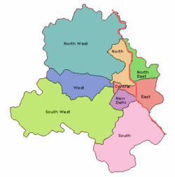
Map showing the old nine districts of Delhi.
The initial nine districts of Delhi came into existence from January 1997. Prior to that, there used to be only one district for whole of Delhi with district headquarters at Tis-Hazari. In September 2012, two new districts, viz. South East and Shahdara were added to the city's map,[1]
The District Administration of Delhi is the enforcement department for all kinds of Government of Delhi and Central Government policies and exercises supervisory over numerous other functionaries of the Government. Below is the list of the districts and subdivisions of Delhi:
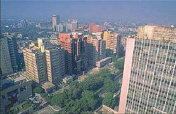
The skyline of Central Delhi
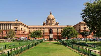
The South Block in New Delhi houses the Indian defence and finance ministries.
New List of Districts in National Capital Territory of Delhi[2]
| Sl.No. | District | Headquarter | Sub divisions (Tehsils) | ||
|---|---|---|---|---|---|
| 1 | New Delhi | Connaught Place | Chanakyapuri | Delhi Cantonment | Vasant Vihar |
| 2 | North Delhi | Narela | Model Town[3] | Narela | Alipur |
| 3 | North West Delhi | Kanjhawala | Rohini | Kanjhawala | Saraswati Vihar |
| 4 | West Delhi | Rajouri Garden | Patel Nagar | Punjabi Bagh | Rajouri Garden |
| 5 | South West Delhi | Dwarka | Dwarka | Najafgarh | Kapashera |
| 6 | South Delhi | Saket | Saket | Hauz Khas | Mehrauli |
| 7 | South East Delhi | Defence Colony | Defence Colony | Kalkaji | Sarita Vihar |
| 8 | Central Delhi | Daryaganj | Kotwali | Civil Lines | Karol Bagh |
| 9 | North East Delhi | Seelampur | Seelampur | Yamuna Vihar | Karawal Nagar |
| 10 | Shahdara | Shahdara | Shahdara | Seemapuri | Vivek Vihar |
| 11 | East Delhi | Preet Vihar | Gandhi Nagar | Preet Vihar | Mayur Vihar |
;;'
Old List of Districts in National Capital Territory of Delhi
| Sl.No. | District | Headquarters | Area (km2) |
Population Census 2011 [4] |
Population Census 2001 |
Population Census 1991 |
Sub divisions | ||
|---|---|---|---|---|---|---|---|---|---|
| 1 | Central Delhi | Daryaganj | 23.36 | 578,671 | 646,385 | 656,533 | Daryaganj | Paharganj | Karol Bagh |
| 2 | North Delhi | Sadar Bazaar | 58.92 | 883,418 | 781,525 | 686,654 | Sadar Bazaar | Kotwali | Civil Lines |
| 3 | South Delhi | Saket | 249.44 | 2,733,752 | 2,267,023 | 1,501,881 | Kalkaji | Defence Colony | Hauz Khas |
| 4 | East Delhi | Preet Vihar | 48.90 | 1,707,725 | 1,463,583 | 1,023,078 | Laxmi Nagar | Preet Vihar | Vivek Vihar |
| 5 | North East Delhi | Shahdara | 56.32 | 2,240,749 | 1,768,061 | 1,085,250 | Shahdara | Naveen Shahdara | Rohtash Nagar |
| 6 | South West Delhi | Palam, Delhi | 420.80 | 2,292,363 | 1,755,041 | 1,087,573 | Vasant Vihar | Najafgarh | Delhi Cantonment |
| 7 | New Delhi | Connaught Place | 34.95 | 133,713 | 179,112 | 168,669 | Connaught Place | Parliament Street | Chanakyapuri |
| 8 | North West Delhi | Kanjhawala | 442.84 | 3,651,261 | 2,860,869 | 1,777,968 | Saraswati Vihar | Narela | Model Town[3] |
| 9 | West Delhi | Rajouri Garden | 130.56 | 2,531,583 | 2,128,908 | 1,433,038 | Patel Nagar | BTM Bagh | [I thik tech park Garden]] |
| Total | 1483.0 | 16,753,235 | 13,850,507 | 9,420,644 | |||||
Municipal Corporations
Apart from these districts, there are five municipalities within the National Capital Territory: three municipal corporations, one municipal council, and one Cantonment Board. They are
- North Delhi Municipal Corporation - Old Districts of North Delhi and North West Delhi.
- South Delhi Municipal Corporation - Old Districts of South Delhi, West Delhi, Central Delhi (excluding Delhi Cantt).
- East Delhi Municipal Corporation - Old Districts of East Delhi, North East Delhi.
- New Delhi Municipal Council - administers the old New Delhi District.
- Delhi Cantonment - administers some part of old South West Delhi.
See also
References
- ↑ Two new districts added to Delhi in 2012
- ↑ districts of delhi. http://www.mapsofindia.com/delhi/districts/. Missing or empty
|title=(help); External link in|website=(help); Missing or empty|url=(help) - 1 2 "North West District: Organisation Setup". Government of Delhi website.
- ↑ "Census of Delhi 2011" (PDF). Government of India website.
| States | ||
|---|---|---|
| Union Territories | ||
| Related topics | ||
This article is issued from
Wikipedia.
The text is licensed under Creative Commons - Attribution - Sharealike.
Additional terms may apply for the media files.