New Hope, Pennsylvania
| Borough of New Hope | |
|---|---|
| Borough | |
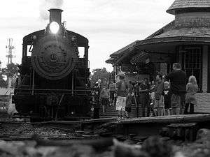
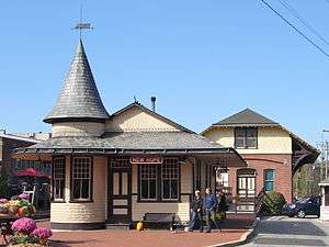 The train station in New Hope | |
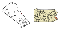 Location of New Hope in Bucks County, Pennsylvania. | |
 New Hope Location of New Hope in Pennsylvania  New Hope New Hope (the US) | |
| Coordinates: 40°21′51″N 74°57′5″W / 40.36417°N 74.95139°WCoordinates: 40°21′51″N 74°57′5″W / 40.36417°N 74.95139°W | |
| Country | United States |
| State | Pennsylvania |
| County | Bucks |
| Government | |
| • Mayor | Laurence D. Keller |
| Area[1] | |
| • Total | 1.42 sq mi (3.68 km2) |
| • Land | 1.27 sq mi (3.29 km2) |
| • Water | 0.15 sq mi (0.38 km2) |
| Elevation | 69 ft (21 m) |
| Population (2010) | |
| • Total | 2,528 |
| • Estimate (2016)[2] | 2,497 |
| • Density | 1,964.59/sq mi (758.50/km2) |
| Time zone | UTC-5 (Eastern (EST)) |
| • Summer (DST) | UTC-4 (EDT) |
| ZIP Code | 18938 |
| Area code(s) | 215 Exchange: 862 |
| FIPS code | 42-53712 |
| GNIS feature ID | 1182332[3] |
New Hope is a borough in Bucks County, Pennsylvania, United States. The population was 2,528 at the 2010 census. New Hope is located approximately 40 mi (64 km) north of Philadelphia, and lies on the west bank of the Delaware River at its confluence with Aquetong Creek. The two-lane New Hope – Lambertville Bridge carries automobile and foot traffic across the Delaware to Lambertville, New Jersey on the east bank.
New Hope's primary industry is tourism.
History


New Hope is located along the route of the Old York Road, the former main highway between Philadelphia and New York City. It was generally regarded as the halfway point, where travelers would stay overnight and be ferried across the Delaware River the next morning. The section of U.S. Route 202 that passes just north of New Hope is still named York Road, and the original route is now known as Bridge Street (PA 179).
New Hope was first called "Coryell's Ferry", after the owner of the ferry business. The current name came into use following a fire in 1790 that destroyed several mills in the area; their reconstruction was considered a "new hope".
The night prior to George Washington's crossing of the Delaware River, he said to have lodged in New Hope. He destroyed the ferry so the British could not follow him, and after the battles of Trenton and Princeton, when British troops were sweeping the area for the American forces, there was no response when they rang for the ferry. The British assumed the town was sympathetic to the Colonial forces and shelled the town. Several of the older structures in the town still claim to have unexploded British ordnance lodged in their roofbeams.
Historic former residents include James A. Michener and Aaron Burr.
The North Pennsylvania Railroad finished construction of their New Hope Branch in 1891, later being taken over by the Reading Railroad. Passenger service to Philadelphia's Reading Terminal as well as all other passenger activity was terminated in 1952 from Hatboro, also the end for electrified track, and New Hope. Between 1952 and 1966, only freight trains were seen entering and leaving New Hope, mostly to deliver paper pulp for the Union Camp Paper Corp. and to deliver sand and gravel to James D. Morrissey Materials Co., a cement company and a division of James D. Morrissey, Inc. In 1966, the New Hope and Ivyland Railroad was formed and bought 16 mi (26 km) of track from New Hope southwest to Ivyland. Scenic tourist excursions started the same year. Freight service to New Hope was then handled by the New Hope and Ivyland Railroad. In 1972, SEPTA, who by then took over Reading Railroad's passenger operations, extended the electrified route to Warminster and reinstated passenger service to the town. Freight service to James D. Morrissey Materials Co. ceased sometime in the late 1970s and to Union Camp Paper Corp. sometime in the mid 1990s. The New Hope and Ivyland Railroad continues to provide scenic tourist excursion passenger trains between New Hope and nearby Lahaska.
In 1983, NBC network anchorwoman Jessica Savitch and her boyfriend drowned after their car overturned into the Delaware Canal. The canal passes by Odette's Restaurant, where the couple had dined on a rainy evening when visibility was poor and warning signs were easily missed.
In 2004 and 2006, New Hope was flooded when the Delaware River overflowed its banks. On both occasions, the downtown businesses reopened within several days. Compared to the Great Flood of 1955, the 2004 and 2006 floods did not cause severe damage or fatalities.
Historic sites
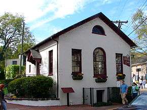
Cintra, Joshua Ely House, Honey Hollow Watershed, William Kitchen House, New Hope Village District, Rhoads Homestead, and Springdale Historic District are listed on the National Register of Historic Places. The Honey Hollow Watershed is also designated a National Historic Landmark District.[4]
Geography
According to the United States Census Bureau, the borough has a total area of 1.4 square miles (3.6 km2), of which 1.3 square miles (3.4 km2) is land and 0.2 square miles (0.52 km2) (11.19%) is water. Much of the water is the Delaware River.
The borough is located at the confluence of the Delaware River and Aquetong (Ingham) Creek, which begins its two-mile course in neighboring Solebury Township at Ingham Springs, the most productive spring in Southeastern Pennsylvania. The name Aquetong comes from a Lenape word meaning "spring in the bushes,"[5] while Ingham refers to Samuel D. Ingham, an industrialist, congressman, and advocate of the canal that would run through the town. Near its end in New Hope, the creek forms a scenic millpond and waterfall near the Bucks County Playhouse, a former mill.
The surrounding area features low, rolling hills, and consists largely of preserved forest and farmland. Many people whose mailing addresses are in New Hope actually live outside the borough in Solebury.
The Delaware River Joint Toll Bridge Commission operates two bridges over the Delaware River between New Hope and Lambertville, New Jersey. One is the free, two-lane New Hope – Lambertville Bridge, and the other, the New Hope – Lambertville Toll Bridge carrying U.S. Highway 202, is a modern toll bridge.
The former place names Hood and Hufnagel are now part of the Borough.[6]
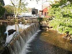 Waterfall and millpond at Aquetong Creek
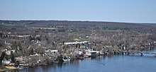
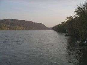 Delaware River at New Hope
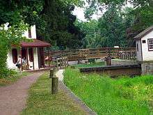 Delaware Canal in New Hope
Climate
New Hope has a hot-summer humid continental climate (Dfa.) The hardiness zone borders 6b and 7a.
| Climate data for New Hope, PA | |||||||||||||
|---|---|---|---|---|---|---|---|---|---|---|---|---|---|
| Month | Jan | Feb | Mar | Apr | May | Jun | Jul | Aug | Sep | Oct | Nov | Dec | Year |
| Average high °F (°C) | 40 (4) |
43 (6) |
52 (11) |
64 (18) |
74 (23) |
83 (28) |
87 (31) |
86 (30) |
79 (26) |
67 (19) |
56 (13) |
45 (7) |
64.666 (18.148) |
| Average low °F (°C) | 18 (−8) |
20 (−7) |
27 (−3) |
37 (3) |
46 (8) |
56 (13) |
61 (16) |
59 (15) |
52 (11) |
40 (4) |
31 (−1) |
23 (−5) |
39.166 (3.981) |
| Source: Weather.com[7] | |||||||||||||
Demographics
| Historical population | |||
|---|---|---|---|
| Census | Pop. | %± | |
| 1840 | 820 | — | |
| 1850 | 1,144 | 39.5% | |
| 1860 | 1,141 | −0.3% | |
| 1870 | 1,225 | 7.4% | |
| 1880 | 1,151 | −6.0% | |
| 1890 | 1,142 | −0.8% | |
| 1900 | 1,218 | 6.7% | |
| 1910 | 1,083 | −11.1% | |
| 1920 | 1,093 | 0.9% | |
| 1930 | 1,113 | 1.8% | |
| 1940 | 1,053 | −5.4% | |
| 1950 | 1,066 | 1.2% | |
| 1960 | 958 | −10.1% | |
| 1970 | 978 | 2.1% | |
| 1980 | 1,473 | 50.6% | |
| 1990 | 1,400 | −5.0% | |
| 2000 | 2,252 | 60.9% | |
| 2010 | 2,528 | 12.3% | |
| Est. 2016 | 2,497 | [2] | −1.2% |
| Sources:[8][9][10] | |||
As of the 2010 census, the borough was 94.6% Non-Hispanic White, 1.5% Black or African American, 0.2% Native American, 2.5% Asian, and 2.6% identified as some other race. 1.5% of the borough identified as two or more races. 7.3% of the population were of Hispanic or Latino ancestry.[11]
As of the census[9] of 2000, there were 2,252 people, 1,160 households, and 506 families residing in the borough. The population density was 1,770.9 people per square mile (684.6/km²). There were 1,251 housing units at an average density of 983.8 per square mile (380.3/km²).
There were 1,160 households, out of which 16.7% had children under the age of 18 living with them, 35.5% were married couples living together, 4.7% had a female householder with no husband present, and 56.3% were non-families. 41.6% of all households were made up of individuals, and 7.8% had someone living alone who was 65 years of age or older. The average household size was 1.94 and the average family size was 2.74.
In the borough the population was spread out, with 15.5% under the age of 18, 5.2% from 18 to 24, 37.3% from 25 to 44, 30.8% from 45 to 64, and 11.3% who were 65 years of age or older. The median age was 41 years. For every 100 females, there were 115.1 males. For every 100 females age 18 and over, there were 121.7 males.
The median income for a household in the borough was $159,008, and the median income for a family was $195,013. Males had a median income of $97,444 versus $62,150 for females. The per capita income for the borough was $68,439. About 0.6% of families and 3.2% of the population were below the poverty line, including 0.3% of those under age 18 and 2.0% of those age 65 or over.[11]
Industry and attractions
New Hope's primary industry is tourism. New Hope has historically been a location where Broadway theatre shows were "tested and fine tuned", and many notable stage actors bought weekend homes in the area. The Bucks County Playhouse featured many plays and musical productions. In 2010, the Playhouse was closed after lenders foreclosed the property. In 2012, the Playhouse re-opened after an extensive renovation.[12]
New Hope was the location of an art colony, founded by Edward Willis Redfield and William Langson Lathrop, that produced noted regional work.[13] Members or associates of the colony included George Sotter, Daniel Garber and Fern Coppedge. Artists also associated with an art colony in nearby Phillips Mill.[14]
New Hope became a popular gay resort in the 1950s, and continues to have an active and large gay community.[15] New Hope also attracts motorcyclists on weekends in the warmer months.
Union Camp Corporation had a bag production facility in New Hope until the mid 1990s, which employed about 100 and was located uphill from the railroad. The former factory complex, now known as Union Square, has been re-purposed into tourism-related shops and businesses.
In 2010, the New Hope and Lambertville area Chambers of Commerce conducted a fireworks show every Friday night during the summer to increase tourism and merchant revenue. Bars and restaurants benefited from the fireworks show, but residents criticized the weekly event, claiming it was disruptive and reduced parking. In 2014, the New Hope Chamber of Commerce cancelled the firework show, citing a rise in shoplifting, garbage, and an overall decline in store traffic and Friday night revenues.[16]
Notable people
- Christian Bauman, novelist and essayist
- Becky Blasband, singer, songwriter and screenwriter
- Amber Brooks, professional women's soccer player
- Aaron Burr, Revolutionary War soldier and Vice President
- Gregg Cagno, singer and songwriter
- Sim Cain, former Rollins Band drummer
- Steve Garvey, musician, Buzzcocks bass player, music producer
- Chad I Ginsburg, guitarist of CKY
- Thomas Holmes, former CEO of Ingersoll Rand
- Aaron Freeman (aka Gene Ween) & Mickey Melchiondo (aka Dean Ween), founding members of the band Ween
- James A. Michener, novelist
- Odette Myrtil, actress, singer, violinist
- George Nakashima, woodworker, architect, and furniture maker who was one of the leading innovators of 20th century furniture design and a father of the American craft movement.
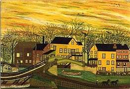
- Joseph Pickett, folk painter
- Antonin Raymond, architect and interior designer
- Bryan Scott, NFL player
- Ted Tally, Oscar-winning screenwriter
- Michael Vick, NFL Quarterback who briefly lived here while playing for the Philadelphia Eagles.
- Winter Ave Zoli, actress
Impressionist artists
- Rae Sloan Bredin, landscape painter
- Morgan Colt, architect and landscape painter
- Fern Coppedge, landscape painter
- Daniel Garber, landscape painter, instructor at the Pennsylvania Academy of the Fine Arts
- L. Birge Harrison, landscape painter, instructor at the Art Students League of New York
- John Fulton Folinsbee, landscape and marine painter
- William Langson Lathrop, landscape painter, founder of the New Hope art colony
- Harry Leith-Ross, Scottish-American landscape painter
- Mary Elizabeth Price, landscape painter
- Edward Willis Redfield, landscape painter
- Charles Rosen, landscape painter
- Walter Elmer Schofield, landscape and marine painter
- Robert Spencer, landscape painter
- George Sotter, landscape painter
See also
References
- ↑ "2016 U.S. Gazetteer Files". United States Census Bureau. Retrieved Aug 13, 2017.
- 1 2 "Population and Housing Unit Estimates". Retrieved June 9, 2017.
- ↑ U.S. Geological Survey Geographic Names Information System: New Hope
- ↑ National Park Service (2010-07-09). "National Register Information System". National Register of Historic Places. National Park Service.
- ↑ "Indian Place Names in Bucks County" (PDF). Lenape Nation - A Tribal Community. Archived from the original (PDF) on 2014-08-10. Retrieved 2012-09-27.
- ↑ MacReynolds, George, Place Names in Bucks County, Pennsylvania, Doylestown, Bucks County Historical Society, Doylestown, PA, 1942, P1.
- ↑ New Hope, PA (18938). Weather.com. 2016 https://weather.com/weather/monthly/l/18938. Retrieved 15 September 2016. Missing or empty
|title=(help) - ↑ "Census of Population and Housing". U.S. Census Bureau. Retrieved 11 December 2013.
- 1 2 "American FactFinder". United States Census Bureau. Retrieved 2008-01-31.
- ↑ "Incorporated Places and Minor Civil Divisions Datasets: Subcounty Resident Population Estimates: April 1, 2010 to July 1, 2012". Population Estimates. U.S. Census Bureau. Archived from the original on 17 June 2013. Retrieved 11 December 2013.
- 1 2 Bureau, U.S. Census. "American FactFinder - Results". factfinder.census.gov. Retrieved 6 May 2017.
- ↑ Reed, Bill. "The curtain rises Monday at the refurbished Bucks County Playhouse". The Philadelphia Inquirer. Retrieved 8 July 2012.
- ↑ Alterman, James (2005). New Hope for American Art. Jim's of Lambertville. ISBN 0-9772665-0-8.
- ↑ "National Historic Landmarks & National Register of Historic Places in Pennsylvania" (Searchable database). CRGIS: Cultural Resources Geographic Information System. Note: This includes Gwen R. Davis (October 1982). "National Register of Historic Places Inventory Nomination Form: Phillips Mill Historic District" (PDF). Retrieved 2012-10-28.
- ↑ "New Hope celebrates its Pride". EDGE Media Network. Retrieved 6 May 2017.
- ↑ "Shoplifting rose, revenues fell during weekly fireworks with Lambertville, says New Hope business group". Retrieved 6 May 2017.
External links
| Wikimedia Commons has media related to New Hope, Pennsylvania. |
| Wikivoyage has a travel guide for New Hope. |
- Official website
- Greater New Hope Chamber of Commerce official website
