Fire Island
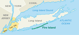
Fire Island is the large center island of the outer barrier islands parallel to the south shore of Long Island, New York. The island is approximately 31 miles (50 km) long and varies between 520 and 1,310 feet (160 and 400 m) wide. Its land area is 9.6 square miles (24.9 square kilometres).[1]
Fire Island is part of Suffolk County. It lies within the towns of Babylon, Islip, and Brookhaven, containing two villages and a number of hamlets. All parts of the island not within village limits are part of the Fire Island census-designated place (CDP), which had a permanent population of 292 at the 2010 census,[2] though that expands to thousands of residents and tourists during the summer months.
In 2012, Hurricane Sandy breached Fire Island in three places. Two of the breaches were filled in, but the third has remained open, and under a plan by the National Park Service, will be left to evolve naturally. As of 2018, Fire Island is still split in two by the breach.
Geography
 L o n g I s l a n d
Great South Bay
F i r e
I s l a n d
|
Fire Island lies an average of 3.9 miles (6.3 km) off the south shore of Long Island, but nearly touches it along the east end. It is separated from Long Island by Great South Bay, which spans interconnected bays along Long Island: Patchogue Bay, Bellport Bay, Narrow Bay, and Moriches Bay. The island is accessible by automobile near each end: via Robert Moses Causeway on its western end, and by William Floyd Parkway (Suffolk County Road 46) near its eastern end. Cross-bay ferries connect to over 10 points in between. Motor vehicles are not permitted on the rest of the island, except for utility, construction and emergency access and with limited beach-driving permits in winter. The island and its resort towns are accessible by boat, seaplane and a number of ferries, which depart from Bay Shore (Fire Island Ferries), Sayville, and Patchogue.
Fire Island is located at 40°39'35" north, 73°5'23" west (40°39′11″N 73°07′34″W / 40.653°N 73.126°WCoordinates: 40°39′11″N 73°07′34″W / 40.653°N 73.126°W).[3] According to the United States Census Bureau, Fire Island has a land area of 9.6 square miles (24.9 km2).[1]
Geographical changes
The dimensions of the island have changed over time and they continue to change. At one point it stretched more than 60 miles (97 km) from Jones Beach Island to Southampton.
Around 1683, Fire Island Inlet broke through, separating it from Jones Beach Island.[4]
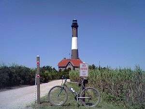
The Fire Island Inlet grew to 9 miles (14 km) in width before receding. The Fire Island Lighthouse was built in 1858, right on the inlet, but Fire Island's western terminus at Democrat Point has steadily moved west so that the lighthouse today is 6 miles (10 km) from the inlet.
Fire Island separated from Southampton in a 1931 Nor'easter when Moriches Inlet broke through. However, this was expected. The inlet widened on September 21, 1938. Moriches Inlet and efforts by local communities east of Fire Island to protect their beach front with jetties have led to an interruption in the longshore drift of sand going from east to west and is blamed for erosion of the Fire Island beachfront.[5] Between these major breaks there have been reports over the years of at least six inlets that broke through the island but have since disappeared.
Etymology
The origin of Fire Island's name is not certain. It is believed its Algonquian name was Sictem Hackey [ˡsiʨtəm ˡhɑʨkaɪ̯], which translates as "Land of the Secatogues". The Secatogues were a tribe in the area of the current town of Islip. It was part of what was also called the "Seal Islands".[6]
The name of Fire Island first appeared on a deed in 1789.[7]
Historian Richard Bayles suggested that the name derives from a misinterpretation or corruption of the Dutch word vijf ("five"), or in another version vier ("four"), referring to the number of islands near the Fire Island inlet.[8] At times histories have referred to it in the plural, as "Fire Islands", because of the inlet breaks.
Other versions say the island derived its name from fires built on the sea's edge by Native Americans or by pirates to lure unsuspecting ships into the sandbars. Some say it is how portions of the island look to be on fire from sea in autumn. Yet another version says it comes from the rash caused by poison ivy on the island.[4]
While the western portion of the island was referred to as Fire Island for many years, the eastern portion was referred to as Great South Beach until 1920, when widespread development caused the whole land mass to be called Fire Island.[7]
History
Settlement
William "Tangier" Smith held title to the entire island in the 17th century, under a royal patent from Thomas Dongan. The remnants of Smith's Manor of St. George are open to the public in Shirley, New York.
- The first large house was built in 1795 in Cherry Grove by Jeremiah Smith. Smith was said to have lured ships to their doom and killed the crews.[9][10]
- In the early 19th century when slavery was still legal in New York, slave runners built stockades on the island by the Fire Island Inlet.
- The first Fire Island Lighthouse was built in 1825 and was replaced by the current lighthouse in 1858.
- In 1855, David S.S. Sammis bought 120 acres (0.49 km2) near the Fire Island Lighthouse and built the Surf Hotel at what today is Kismet. Sammis operated the hotel until 1892, when the state took it over. In 1908, it became the first state park on Long Island.
- In 1868, Archer and Elizabeth Perkinson bought the land around Cherry Grove and Fire Island Pines. They built a hotel in 1880.
- In 1887, the Coast Guard established 11 manned lifesaving stations on the island.
- In 1892, troops were called out to suppress a potential riot at Democrat Point over a cholera panic.[11]
- In 1908, Ocean Beach was established, followed by Saltaire in 1910.
- In 1921, the Perkinsons sold the land around Cherry Grove in small lots. Bungalows from the newly closed Camp Upton in Yaphank were ferried over the Great South Bay to build the new community. Duffy's Hotel was built in 1930.
- The Great Hurricane of 1938 devastated much of the island and made it appear undesirable to many. However, Duffy's Hotel remained relatively undamaged. According to legend, the gay population began to concentrate in Cherry Grove at Duffy's Hotel with Christopher Isherwood and W. H. Auden dressed as Dionysus and Ganymede and carried aloft on a gilded litter by a group of singing followers.[12] The gay influence was continued in the 1960s when male model John B. Whyte developed Fire Island Pines. The Pines currently has some of the most expensive property on the island and accounts for two-thirds of the island's swimming pools.[13]
- In 1964, Robert Moses built the Captree Causeway to the western end of the island.[14] Opponents, fearing that this was the beginning of plans for the continuation of Ocean Parkway, which would have run down the middle of the island, organized and eventually stopped the parkway.
- In September 1964, Lyndon Johnson signed a bill creating Fire Island National Seashore.
2009: Beach renourishment
A 2009 beach renourishment program was credited with saving the island from the full effects of Hurricane Sandy in 2012.
In the winter and spring of 2009, a beach renourishment project was undertaken on Fire Island, with the cooperation of the National Park Service, the U.S. Army Corps of Engineers, the Towns of Brookhaven and Islip, and Fire Island residents. The renourishment program involved dredging sand from an offshore borrow area, pumping it onto the beach and shaping the sand into an approved beach face and dune template in front of the communities of Corneille Estates, Davis Park, Dunewood, Fair Harbor, Fire Island Pines, Fire Island Summer Club, Lonelyville, Ocean Bay Park, Ocean Beach, Saltaire, and Seaview. Fire Islanders agreed to a significant property tax increase to help pay for the project, which was estimated to cost between $23 and $25 million ($6,020 per housing unit), including the cost of environmental monitoring, and was expected to add 1,400,000 cubic meters (1,800,000 cubic yards) of sand in front of the participating communities. The Towns of Brookhaven and Islip, in which the communities are located, issued bonds to pay for the project, backed by the new taxes levied by community Erosion Control Taxing Districts.
2012: Hurricane Sandy
The island was heavily damaged in the high tides associated with Hurricane Sandy in 2012, including three breaches around Smith Point County Park on the sparsely populated east end of the island. The biggest breach was at Old Inlet in the Otis Pike Wilderness Area just west of Smith Point County Park; it was 108 feet wide after the storm on the south end and 1,171 feet on February 28, 2013.[15] Officials debated whether to close the breach but ultimately decided to let nature take its course, as the breach has been flushing out the Great South Bay and improving water quality. Residents of the bay front communities noted increased flooding after the storm, which was later found to be the result of several nor'easters and unrelated to the breaches.[16] As of 2017, the breach remained open. Officials moved to close the other two breaches which are on either side of Moriches Inlet—one in Cupsogue County Park and the other one being in Smith Point County Park.[17][18][19]
Reports indicated that 80 percent of the homes on the island were flooded and 90 homes were completely destroyed.[20] The storm also tore away about 75 feet of the dune coastline. Most of the 4,500 homes on the island were still intact, although damaged by floodwaters; officials credited the dune replenishment program with helping to spare the island.[21]
Landmarks and preserves
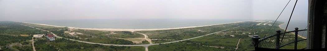
Except for the western 4 1⁄2 miles (7.2 km) of the island, the island is protected as part of Fire Island National Seashore. Robert Moses State Park, occupying the remaining western portion of the island, is one of the popular recreational destinations in the New York City area. The Fire Island Lighthouse stands just east of Robert Moses State Park.
A memorial to TWA 800 is located on the eastern end at Smith Point County Park near where the airplane blew up and crashed at sea in 1996.
Locations
Following are the locations on the island. Townships and communities are listed from west to east.[22]
Town of Babylon
Town of Islip
- Robert Moses State Park (part)
- Fire Island Light
- Kismet
- Seabay Beach
- Saltaire (village)
- Fair Harbor
- Dunewood
- Lonelyville
- Atlantique
- Robbins Rest
- Fire Island Summer Club
- Corneille Estates
- Ocean Beach (village)
- Seaview
Town of Brookhaven
- Seaview
- Ocean Bay Park
- Point O'Woods
- Oakleyville
- Sunken Forest
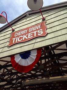
- Cherry Grove
- Fire Island Pines
- Talisman/Barrett Beach
- Water Island
- Blue Point Beach
- Davis Park/Ocean Ridge
- Watch Hill, National Park Service facility in the central part of the island, including a public marina, camp ground visitor center, and nature trail.
- Otis Pike Fire Island High Dune Wilderness
- Bellport Beach
- Smith Point County Park
- Moriches Inlet
Other surrounding small islands
The following are associated islands in the Fire Island National Seashore Jurisdiction, from west to east:
- Sexton Island, a small island across from the Fire Island Lighthouse with approximately 20 small, private, summer houses. There is no ferry service or electrical service.
- West Fire Island, a small island with about a dozen houses. It has no telephone or electrical service.
- East Fire Island, another longer and larger island next to West Fire Island. East Fire Island, unlike West Fire Island, is uninhabited. People are allowed, although there is no ferry service and the only way to get there is on your own boat.
- Ridge Island
- Pelican Island
- John Boyle Island
- Hospital Island
- Money Island
- Penny Island
Other locations
- Clam Pond, a small cove between Saltaire and Fair Harbor
Inhabitants
Fire Island's population varies seasonally. There are few residents in winter months, with the population rising in the late spring to early fall.
Housing is mostly stick-built bungalow-style with generous helpings of bamboo. Some are beachfront, built on the dunes of the Atlantic Ocean, while others are on boardwalks or concrete walks, like a miniaturized city. For year-round residents, there are schools, churches, synagogues, shops and even a school bus service to Long Island via an off-road modified school bus.
The quiet villages on Fire Island provide solitude, while the larger towns like Ocean Beach and Cherry Grove provide a more social atmosphere with clubs, bars and open air dining. Two of these hamlets, Fire Island Pines and Cherry Grove, are destinations for LGBT vacationers.
The incorporated villages of Ocean Beach and Saltaire within Fire Island National Seashore are car-free during the summer tourist season (Memorial Day through Labor Day) and permit only pedestrian and bicycle traffic (during certain hours only in Ocean Beach). For off-season use, there are a limited number of driving permits for year-round residents and contractors. The hamlet of Davis Park allows no vehicles or bicycles year-round.
Demographics
As of the census[23] of 2000, there were 491 people, 138 households, and 77 families residing on Fire Island. The population density was 52.82/mi2 (21.82/km2). There were 4,153 housing units, at an average density of 478.1/mi2 (184.6/km2). The racial makeup of the town was 96.77% White, 0.65% Asian, 0.32% Pacific Islander, 0.65% from other races, and 1.61% from two or more races. Hispanic or Latino of any race were 2.90% of the population.
There were 138 households on Fire Island, out of which 25.4% had children under the age of 18 living with them, 48.6% were married couples living together, 2.2% had a female householder with no husband present, and 44.2% were non-families. 34.8% of all households were made up of individuals and 10.1% had someone living alone who was 65 years of age or older. The average household size was 2.20 and the average family size was 2.90.
Fire Island's population was spread out with 20.6% under the age of 18, 6.5% from 18 to 24, 29.0% from 25 to 44, 33.5% from 45 to 64, and 10.3% who were 65 years of age or older. The median age was 42 years. For every 100 females, there were 133.1 males. For every 100 females age 18 and over, there were 143.6 males.
The median income for a household on Fire Island was $73,281, and the median income for a family was $83,672. Males had a median income of $46,875 versus $41,429 for females. The per capita income for Fire Island was $43,681. 0.0% of families and 3.1% of individuals were below the poverty line, including 0.0% of those under age 18 and 8.6% of those age 65 or over.
Famous summer residents
After the Manhattan theater community began staying on Fire Island during the 1920s, the island had numerous summer celebrity residents.[24]
- Gary Beach, Tony award-winning actor.[25]
- Mel Brooks and his wife Anne Bancroft (d. 2005) owned a beach home. There, with Carl Reiner, Brooks wrote the "2000 Year Old Man."[26]
- Barbara Corcoran, investor and TV personality.[27]
- Tina Fey, comedian, film and Saturday Night Live actor, creator of 30 Rock, who stays during the summer at Fair Harbor.[28]
- Henry Fonda (d. 1982), actor who built a summer home in the Pines.[29]
- Wolcott Gibbs, theater critic of The New Yorker died there in 1958.[30]
- John Lennon (d. 1980), of The Beatles. The piano he shipped there is now at the Rock and Roll Hall of Fame in Cleveland, Ohio.[31]
- Joan McCracken (d. 1961), dancer, actress, comedian, who spent much of her final years there.[32]
- Christopher Noth, Sex and the City and Law and Order star, summered in Ocean Beach.
- Frank O'Hara, writer, poet, art critic and curator at the Museum of Modern Art, who died after being struck there by a dune buggy in 1966.[33]
- Lea Thompson, Back to the Future star, and her director husband Howard Deutch.[34]
- Fanny Brice, (d. 1951) Ziegfeld Follies, stage and film star, created and starred in top-rated radio comedy series The Baby Snooks Show.[35]
- Ring Lardner, Jr. (d. 2000), journalist and blacklisted screenwriter.[36]
- Joseph Heller (d. 1999), Catch 22 author.[37]
- General George Marshall (d. 1959), General of the Army, Secretary of State, and creator of the Marshall Plan.[38]
Emergency services
Fire Island's unique location and constantly changing geography play a major role in the protection of its citizens. Although it is served by nine fire departments and two police departments,[39] the seasonal residency and remote driving distance are a challenge to the public safety community. Because there are no roads on inhabited Fire Island, fire department vehicles are heavily modified four-wheel drive with suspension lifts, large diameter off-road tires and recovery equipment, which allow them to traverse the sometimes washed-out, loose sand.
Until 1986, there was no ambulance service on Fire Island,[40] prompting the village of Saltaire to form its rescue company, later followed by Ocean Beach, and then in 2004 with Fair Harbor.[41] Due to relatively close distances, fire departments on Fire Island are obliged to provide mutual aid to neighboring communities.[42] Some coastal fire departments on Long Island have fully equipped marine rescue and fire boat units which can cross the Great South Bay to provide necessary assistance.
Fire Island's corps of off-road-capable fire apparatus and the firefighters' training to use them effectively provide much-needed support in the event of a wildfire, as was illustrated in the Long Island Central Pine Barrens fires of 1995.
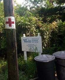
Northwell Health recently opened two urgent care facilities on Fire Island (one in Ocean Beach and the other in Cherry Grove). These centers operate during the summer from Memorial Day through Labor Day, and are open for walk-in patient visits seven days a week from 9 to 11 AM and 4 to 6 PM. If patients require medical treatment outside of those hours, the Immediate Care Center’s physician can be reached on call by contacting local police.[43]
Good Samaritan Hospital Medical Center, Southside Hospital, and Brookhaven Memorial Hospital Medical Center are located directly across the Great South Bay from Fire Island in the Long Island hamlets of West Islip, Bay Shore, and the village of Patchogue, respectively. A heliport for medevac helicopter use is adjacent to Good Samaritan Hospital Medical Center. Specially equipped boats provided by the Suffolk County Police Department Marine Bureau docked at the various communities on Fire Island provide emergency transportation to individuals in need of dire medical care. In many cases, Long Island based ambulances will meet the boats once they cross the Bay (roughly 4.5 miles) and then drive individuals the short distance to one of the three hospitals.
The Suffolk County Police Department Marine Bureau is the primary law enforcement agency.[44] Ocean Beach also has a dedicated police department of its own.[45] Criminal proceedings are handled by Suffolk District Court and subjects that are arrested will go to the 3rd, 1st or 5th precinct, or to one of the Suffolk County Sheriff's Office-run jails. Small claims and property matters are usually handled by the individual village of case origin.[46][47] It is common practice for police to write tickets then send unruly visitors off the island via water taxi, at the offender's expense.[48]
The Suffolk County Park Police and New York State Park Police patrol the Robert Moses State Park, while the National Park Service is stationed at the Fire Island Light and Fire Island National Seashore.
The United States Coast Guard has a base on Fire Island and provides aerial and nautical patrols to the Fire Island National Seashore as well as all beaches in the area. One of the oldest Coast Guard stations in America, Station #25 has been in uninterrupted operation since 1849.[49]
In popular culture
- Fire Island in the year 1858 is the setting of the historical fiction novel Fire Island written by John J. Stevens.
- In 1972 Anthony Ingrassia wrote and produced the show Island.[50][51] The play starred Patti Smith, Cherry Vanilla and Jayne County. It was set at a beach house on Fire Island and featured a dysfunctional family and their houseguests. Reportedly Ingrassia hired Smith because of how she looked, and rewrote the play to feature her prominently.[52]
- The song "Come to Me" has been described as "the definitive Fire Island dance classic" because of the legendary beach concert performance by the 16-year-old France Joli before an oceanfront Fire Island audience of 5000 on July 7, 1979. When Donna Summer cancelled at the last minute, Joli stepped in as a replacement and became an overnight sensation.[53]
- The song "Gay Messiah" on the 2004 album Want Two by Rufus Wainwright makes a reference to the popularity of Fire Island for gay and lesbian tourists, remarking that when the "gay messiah" comes, "He will fall from the star / of Studio 54 / and appear on the sand / of Fire Island's shore".
- Fire Island features heavily in the Andrew Holleran novel Dancer from the Dance about life in gay New York.
- The 2003 album Welcome Interstate Managers by Fountains of Wayne featured the song "Fire Island" about two siblings' home-alone shenanigans while their parents vacation on the island.
- The Village People included a song titled "Fire Island" on their 1977 debut album, Village People. In the song, they refer to the island as "a funky weekend" and mention several locations on the island such as the Ice Palace, the Monster, the Blue Whale, and the Sandpiper. The song also includes the warning "Don't go in the bushes" because "someone might grab ya" or "someone might stab ya."
- The American writer Patricia Nell Warren, known as "the mother of Frontrunners" — the Gay, Lesbian, Bisexual, and Transgender running/walking clubs — locates parts of her 1974 The Front Runner,[54] as well as of Harlan's Race,[55] a 1994 sequel, on Fire Island.
- Fire Island is featured prominently in Ann Brashares's 2008 novel The Last Summer (of You and Me), about two sisters and a friend who grow up together, vacationing on the island every summer.
- Fire Island serves dual meanings as both a vacation destination and a homoerotic euphemism in Dress Your Family in Corduroy and Denim by David Sedaris.
- The novel Auntie Mame by Patrick Dennis uses a Fire Island reference to emphasize that the eponymous character keeps "queer" company.
- Fire Island is repeatedly referenced on the NBC sitcom Will & Grace.
- When Ocean Meets Sky,[56] a 2003 documentary detailing the 50-year history of the Fire Island Pines community, had its television premiere on June 10, 2006. The film includes much previously unseen archival footage.
- The mockumentary Beach Comber[57] was filmed on Fire Island in 2004.
- ABC's reality show One Ocean View (2006) was shot on Fire Island.
- Frank Perry's Last Summer (1969), adapted by Eleanor Perry from Evan Hunter's novel about a summer of sexual discovery on Fire Island, brought an Oscar nomination for actress Catherine Burns.
- A feature entitled "Shel Silverstein on Fire Island" appeared in the August 1965 Playboy magazine, with humorous quips about the gay club scene there.
- Fire Island is also the setting of Terrence McNally's play Lips Together, Teeth Apart.
- In their song "Raw Deal" Judas Priest refer to Fire Island and a gay club called "Spike".
- Fire Island is mentioned in the book Kramer Vs. Kramer by novelist Avery Corman.
- In the Family Guy episode "The Father, the Son and the Holy Fonz" (2005), there is a cutaway gag of "Jaws 5: Fire Island." It shows two presumably gay men swimming in the ocean, with a large shark looking up at them from below. The shark's thoughts can be heard, as he ponders in an effeminate voice whether or not he should eat the swimmers due to the calories.[58]
- A Fire Island series airing in April 2017 is about a group of young gay guys living in a beachfront share house on Fire Island for the summer.[59]
- In Woody Allen's Annie Hall, as he and Diane Keaton's title character are people-watching, a male gay couple walk past and Allen's Alvy Singer quietly points out: "Oh, that's hilarious. They're back from Fire Island."
See also
References
- 1 2 Consisting of the Fire Island CDP plus the villages of Saltaire and Ocean Beach: "Geographic Identifiers: 2010 Demographic Profile Data (G001): Fire Island CDP, New York". U.S. Census Bureau, American Factfinder. Retrieved 2012-12-28. "Geographic Identifiers: 2010 Demographic Profile Data (G001): Saltaire village, New York". U.S. Census Bureau, American Factfinder. Retrieved 2012-12-28. "Geographic Identifiers: 2010 Demographic Profile Data (G001): Ocean Beach village, New York". U.S. Census Bureau, American Factfinder. Retrieved 2012-12-28.
- ↑ "Geographic Identifiers: 2010 Demographic Profile Data (G001): Fire Island CDP, New York". U.S. Census Bureau, American Factfinder. Retrieved 2012-12-28.
- ↑ "US Gazetteer files: 2010, 2000, and 1990". United States Census Bureau. 2011-02-12. Retrieved 2011-04-23.
- 1 2 Thompson, B. F. (1839). History of Long Island; containing an account of the discovery and settlement; with other important and interesting matters to the present time. New York, E. French.
- ↑ "The Great Hurricane of 1938 - Geological Impact". .sunysuffolk.edu. December 12, 1992. Retrieved 2010-09-23.
- ↑ Edwards, C. (1935). A History of Early Sayville, Sayville, N.Y.: Suffolk County News Press
- 1 2 National Park Service history. Retrieved 2007-11-02.
- ↑ "history - Retrieved 2007-11-02". Fairharbor.com. January 23, 2005. Retrieved 2010-09-23.
- ↑ Fire Island: From Pirates to Slavery to Fun in the Sun - Newsday Retrieved 2007-11-03 Archived January 6, 2008, at the Wayback Machine.
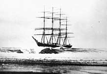
- ↑ Stansell, Christine. The New Republic. March 26, 2008. From an article on the life of Margaret Fuller, who died 1850 in a shipwreck at Fire Island: "The Fire Islanders of the day were a nasty group, who lived off pickings from shipwrecks that washed up on the beach, and they had no use for rescue efforts. So although the boat was in clear sight of the shore, no one acted while there was time. The family spent the night with other desperate passengers huddled on the disintegrating ship."
- ↑ Dewan, George (2005). "The 1892 cholera panic". Newsday. Archived from the original on 2005-04-27. Retrieved 2015-08-14.
- ↑ Cherry Grove Fire Island by Esther Newton – 1995 - Beacon Press ISBN 0-8070-7927-8
- ↑ "Fire Island Pines Chamber of Commerce - Retrieved 2007-10-31". Fireislandcc.org. Retrieved 2010-09-23.
- ↑ "Robert Moses Causeway Historic Overview". Eastern Roads. Retrieved 2011-03-28.
This final link of the Robert Moses Causeway opened in 1964.
- ↑ "Post-Hurricane Sandy: Old Inlet Breach on Fire Island - Fire Island National Seashore". Nps.gov. Retrieved 2013-04-06.
- ↑ Barrios, Jennifer (2014-03-28). "Fire Island breaches not to blame for coastal flooding, USGS study shows". Newsday. Retrieved 2015-08-14.
- ↑ Timothy Bolger (302 Posts) (2013-03-14). "Fire Island Breach Needs to be Closed, Bellone Says". Long Island Press. Retrieved 2013-04-06.
- ↑ "Fire Island Cut in Two! Breach at the Old Inlet Sandy 2012". Fireisland.com. Retrieved 2013-04-06.
- ↑ Lisa W. Foderaro (April 6, 2013). "Breach Through Fire Island Also Divides Opinions". The New York Times. p. A13. Retrieved 2013-07-30.
- ↑ "Residents Return To Fire Island, Where The Protective Dunes Are No More « CBS New York". Newyork.cbslocal.com. 2012-11-14. Retrieved 2013-04-06.
- ↑ Lisa W. Foderaro (November 20, 2012). "After Saving Fire Island, Line of Defense Is Lost to the Sea". The New York Times. p. A18. Retrieved 2013-07-30.
- ↑ "Official NPS Map - Retrieved 2007-11-02" (PDF). Retrieved 2010-09-23.
- ↑ "American FactFinder". United States Census Bureau. Archived from the original on 2013-09-11. Retrieved 2008-01-31.
- ↑ "Nadelson, Reggie. ''Travel + Leisure'', "Hit the Beach in Fire Island," July 2003". Travelandleisure.com. Retrieved 2010-09-23.
- ↑ "''Playbill''". Playbill.com. November 20, 2005. Retrieved 2010-09-23.
- ↑ "Living in Lonelyville Fire Island". Retrieved July 26, 2015.
- ↑ "Barbara Corcoran's Photos". Facebook. Retrieved 2012-10-17.
- ↑ "The Heart of Fire Island". Retrieved July 26, 2015.
- ↑ "Fire Island New York". Retrieved July 26, 2015.
- ↑ "Thurber Tonight: About Wolcott Gibbs". 2003-03-09. Retrieved July 26, 2015.
- ↑ "The Beatles". Retrieved July 26, 2015.
- ↑ "Joan McCracken". Retrieved July 26, 2015.
- ↑ Hendrix, Jenny. "The mystery behind Frank O'Hara's most famous poem". Retrieved July 26, 2015.
- ↑ Maloney, Michael (2012-10-30). "'Back to the Future' star fears her home is lost to Sandy". Today. Retrieved July 26, 2015.
- ↑ "Escapades on Fire Island". Retrieved July 26, 2015.
- ↑ Gilford, Joe (2013-04-24). "Blacklisted, from a child's view". The New York Times. Retrieved July 26, 2015.
- ↑ Lawson, Mark (1994-09-25). "Joey Heller's happy ending: Joseph Heller's new novel is the long-awaited sequel to Catch-22. It is also a summing-up: a valedictory meditation on the approaching end - of his life, of his life's work, and of the 20th century and its values. Yet these morbid reflections have left him curiously cheerful". Retrieved July 26, 2015.
- ↑ "Marshall and Fire Island". Retrieved 5 January 2017.
- ↑ "Suffolk County F.D. & E.M.S. Radio Codes & Information". Fordyce.org. Retrieved 2012-04-18.
- ↑ "About SVFC - Saltaire Volunteer Fire Company". Saltairefd.com. Retrieved 2012-04-18.
- ↑ "EMS Fair Harbor Fire Department". 2014. Retrieved July 26, 2015.
- ↑ "A Fire in Fire Island Pines Reportedly Destroys Pavilion Complex | Out Magazine". Out.com. November 15, 2011. Retrieved 2012-04-18.
- ↑ "Immediate Care Center Fire Island". Retrieved July 26, 2015.
- ↑ "Suffolk County Police Dept". Retrieved July 26, 2015.
- ↑ "Village of Ocean Beach". Retrieved July 26, 2015.
- ↑ "Village of Ocean Beach". Retrieved July 26, 2015.
- ↑ "Saltaire Village Code, Chapter 1" (PDF). Retrieved July 26, 2015.
- ↑ Deirdre M Gurry. "City Chick: Fire Island". Copia Magazine. Retrieved 2012-04-18.
- ↑ "Station Fire Island, New York" (PDF). Uscg.mil. Retrieved 2013-01-02.
- ↑ Fame, retrieved 16 September 2015
- ↑ Vanilla, Cherry (2010), Lick Me: How I Became Cherry Vanilla, retrieved 16 September 2015
- ↑ Bockris, Bockris; Bayley, Roberta (1999), Patti Smith: An Unauthorized Biography, Simon & Schuster, retrieved 16 September 2015
- ↑ Ferguson, Dean. "France Joli: Full Circle," DMA/Dance Music Authority, Volume 4, Number 11, December 1996.
- ↑ ISBN 0-9641099-6-4
- ↑ ISBN 0-9641099-5-6
- ↑ "When Ocean Meets Sky". Craytonrobeyproductions.com. Archived from the original on 2011-01-28. Retrieved 2010-09-23.
- ↑ "Beach Comber". Google. Retrieved 2010-09-23.
- ↑ Theelinrot (2011-07-05), Family Guy Gay Shark, retrieved 2017-03-09
- ↑ Andy Towle (March 6, 2017). "The Trailer for Logo's 'Fire Island' Reality Show Just Arrived on the Ferry: WATCH". Towleroad. Retrieved March 30, 2017.
External links
| Wikimedia Commons has media related to Fire Island. |
| Wikivoyage has a travel guide for Fire Island. |