Monticello, New Mexico
| Monticello | |
|---|---|
| Unincorporated community | |
 Monticello Location within the state of New Mexico  Monticello Monticello (the US) | |
| Coordinates: 33°23′49″N 107°27′03″W / 33.39694°N 107.45083°WCoordinates: 33°23′49″N 107°27′03″W / 33.39694°N 107.45083°W | |
| Country | United States |
| State | New Mexico |
| County | Sierra |
| Elevation | 5,256 ft (1,602 m) |
| Time zone | UTC-7 (Mountain (MST)) |
| • Summer (DST) | UTC-6 (MDT) |
| Area code(s) | 575 |
| GNIS feature ID | 908852[1] |
Monticello is an unincorporated community located in Sierra County, New Mexico, United States. Monticello is located on Alamosa Creek 22 miles (35 km) northwest of Truth or Consequences. Monticello has a post office with ZIP code 87939.[2][3]
History
Monticello was laid out in 1856, and named after Monticello, New York, the former home of an early settler.[4] A post office called Monticello has been in operation since 1881.[5]
References
- ↑ "Monticello". Geographic Names Information System. United States Geological Survey.
- ↑ "Postmaster Finder - Post Offices by ZIP Code". United States Postal Service. Retrieved November 9, 2014.
- ↑ United States Postal Service. "USPS - Look Up a ZIP Code". Retrieved November 9, 2014.
- ↑ Harris, Linda G. (2003). Ghost Towns Alive: Trips to New Mexico's Past. UNM Press. p. 152. ISBN 978-0-8263-2908-0.
- ↑ "Sierra County". Jim Forte Postal History. Retrieved 29 October 2015.
Municipalities and communities of Sierra County, New Mexico, United States | ||
|---|---|---|
| Cities | 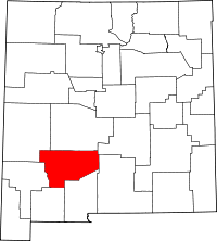 | |
| Villages | ||
| CDPs | ||
| Other communities | ||
| Ghost towns | ||
This article is issued from
Wikipedia.
The text is licensed under Creative Commons - Attribution - Sharealike.
Additional terms may apply for the media files.