National Register of Historic Places listings in Socorro County, New Mexico
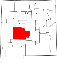
Location of Socorro County in New Mexico
This is a list of the National Register of Historic Places listings in Socorro County, New Mexico.
This is intended to be a complete list of the properties and districts on the National Register of Historic Places in Socorro County, New Mexico, United States. Latitude and longitude coordinates are provided for many National Register properties and districts; these locations may be seen together in a map.[1]
There are 53 properties and districts listed on the National Register in the county, including 1 National Historic Landmark. Two additional properties were once listed but have been removed. All of the places within the county on the National Register are also listed on the State Register of Cultural Properties.
- This National Park Service list is complete through NPS recent listings posted October 11, 2018.[2]
| Bernalillo – Catron – Chaves – Cibola – Colfax – Curry – De Baca – Doña Ana – Eddy – Grant – Guadalupe – Harding – Hidalgo – Lea – Lincoln – Los Alamos – Luna – McKinley – Mora – Otero – Quay – Rio Arriba – Roosevelt – San Juan – San Miguel – Sandoval – Santa Fe – Sierra – Socorro – Taos – Torrance – Union – Valencia |
Current listings
| [3] | Name on the Register[4] | Image | Date listed[5] | Location | City or town | Description |
|---|---|---|---|---|---|---|
| 1 | Aragon House | August 2, 1982 (#82003327) |
2nd and Oak Sts. 34°06′55″N 107°14′44″W / 34.115273°N 107.245529°W |
Magdalena | ||
| 2 | Archeological Site No. LA 1069 |  |
April 15, 1993 (#93000243) |
Address Restricted |
Bingham | |
| 3 | Archeological Site No. LA 1070 | |
April 15, 1993 (#93000244) |
Address Restricted |
Bingham | |
| 4 | Archeological Site No. LA 1071 | |
April 15, 1993 (#93000245) |
Address Restricted |
Bingham | |
| 5 | Archeological Site No. LA 1072 | |
April 15, 1993 (#93000246) |
Address Restricted |
Bingham | |
| 6 | Archeological Site No. LA 1073 | |
April 15, 1993 (#93000247) |
Address Restricted |
Bingham | |
| 7 | Archeological Site No. LA 1074 | |
April 15, 1993 (#93000248) |
Address Restricted |
Bingham | |
| 8 | Archeological Site No. LA 1075 | |
April 15, 1993 (#93000249) |
Address Restricted |
Bingham | |
| 9 | Archeological Site No. LA 1076 | |
April 15, 1993 (#93000250) |
Address Restricted |
Bingham | |
| 10 | Archeological Site No. LA 1181 | |
April 15, 1993 (#93000251) |
Address Restricted |
Bingham | |
| 11 | Archeological Site No. LA 1201 | |
April 15, 1993 (#93000252) |
Address Restricted |
Bingham | |
| 12 | Atchison, Topeka and Santa Fe Railway Depot | 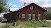 |
December 29, 1978 (#78001829) |
108 N. Main Street[6] 34°07′06″N 107°14′36″W / 34.118269°N 107.243437°W |
Magdalena | Now the village hall and library[7] |
| 13 | A.B. Baca House | .JPG) |
February 20, 1991 (#91000036) |
201 School of Mines Rd. 34°03′31″N 106°53′38″W / 34.058611°N 106.893889°W |
Socorro | |
| 14 | Bank of Magdalena | _from_SW_2.JPG) |
August 2, 1982 (#82003328) |
1st and Main Sts. 34°07′02″N 107°14′36″W / 34.117194°N 107.243219°W |
Magdalena | |
| 15 | Brown Hall | 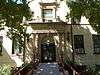 |
May 16, 1989 (#88001550) |
New Mexico Institute of Mining and Technology 34°03′59″N 106°54′17″W / 34.066389°N 106.904722°W |
Socorro | |
| 16 | Bursum House | 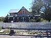 |
June 18, 1975 (#75001172) |
326 Church St. 34°03′20″N 106°53′46″W / 34.055556°N 106.896111°W |
Socorro | |
| 17 | Camino Real-Qualacu Pueblo | |
April 8, 2011 (#11000173) |
Address Restricted |
San Antonio vicinity | part of the Camino Real in New Mexico, AD 1598-1881 Multiple Property Submission |
| 18 | Camino Real-San Pascual Pueblo | |
April 8, 2011 (#11000164) |
Address Restricted |
San Antonio vicinity | part of the Camino Real in New Mexico, AD 1598-1881 Multiple Property Submission |
| 19 | Clemens Ranchhouse | April 18, 1979 (#79001557) |
South of Magdalena 34°05′03″N 107°13′46″W / 34.084167°N 107.229444°W |
Magdalena | ||
| 20 | Captain Michael Cooney House | 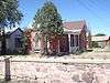 |
February 20, 1991 (#91000029) |
309 McCutcheon Ave. 34°03′19″N 106°53′40″W / 34.055278°N 106.894444°W |
Socorro | |
| 21 | Anthony Cortesy House | 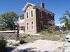 |
February 20, 1991 (#91000033) |
327 McCutcheon Ave. 34°03′19″N 106°53′46″W / 34.055278°N 106.896111°W |
Socorro | |
| 22 | Nestor P. Eaton House | 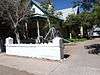 |
February 20, 1991 (#91000034) |
313 McCutcheon Ave. 34°03′19″N 106°53′41″W / 34.055278°N 106.894722°W |
Socorro | |
| 23 | El Camino Real de Tierra Adentro-Arroyo Alamillo North Section | |
November 5, 2014 (#14000898) |
Address restricted |
San Acacia vicinity | |
| 24 | Fitch Hall | 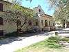 |
May 16, 1989 (#88001551) |
New Mexico Institute of Mining and Technology 34°03′55″N 106°54′15″W / 34.065278°N 106.904167°W |
Socorro | |
| 25 | James Gurden Fitch House | 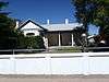 |
February 20, 1991 (#91000035) |
311 McCutcheon Ave. 34°03′19″N 106°53′40″W / 34.055278°N 106.894444°W |
Socorro | |
| 26 | Fort Craig | 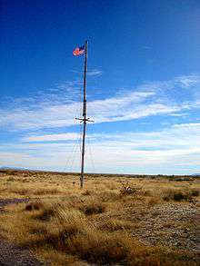 |
October 15, 1970 (#70000414) |
37 miles (60 km) south of Socorro 33°38′25″N 107°00′46″W / 33.640278°N 107.012778°W |
Socorro | |
| 27 | Gallinas Springs Ruin | |
September 4, 1970 (#70000413) |
Address Restricted |
Magdalena | |
| 28 | Garcia Opera House | 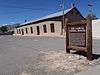 |
August 13, 1974 (#74001210) |
Terry Ave. and California St. 34°03′30″N 106°53′28″W / 34.058333°N 106.891111°W |
Socorro | |
| 29 | Juan Nepomuceno Garcia House | February 20, 1991 (#91000027) |
108 Bernard St. 34°03′29″N 106°53′32″W / 34.058056°N 106.892222°W |
Socorro | ||
| 30 | Gran Quivera Historic District | 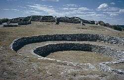 |
June 15, 2015 (#15000355) |
Along NM 55 approx. 25 mi. S. of Mountainair 34°15′55″N 106°06′09″W / 34.2654°N 106.1024°W |
Mountainair vicinity | Part of Salinas Pueblo Missions National Monument; extends into Torrance County |
| 31 | Gutierrez House | _from_SW_1.JPG) |
August 2, 1982 (#82003329) |
3rd and Popular Sts. 34°07′00″N 107°14′19″W / 34.11663°N 107.238716°W |
Magdalena | |
| 32 | Hall Hotel | 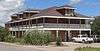 |
August 2, 1982 (#82003330) |
2nd and Spruce Sts. 34°07′00″N 107°14′30″W / 34.116788°N 107.241611°W |
Magdalena | |
| 33 | Hilton House | _from_NW_2.JPG) |
August 2, 1982 (#82003331) |
U.S. Route 60 34°07′13″N 107°13′59″W / 34.12019°N 107.233054°W |
Magdalena | |
| 34 | August Holver Hilton House | 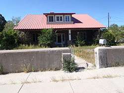 |
February 20, 1991 (#91000031) |
601 Park St. 34°03′05″N 106°53′35″W / 34.051389°N 106.893056°W |
Socorro | |
| 35 | House at 303 Eaton Avenue | 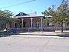 |
February 20, 1991 (#91000032) |
303 Eaton Ave. 34°03′20″N 106°53′50″W / 34.055556°N 106.897222°W |
Socorro | |
| 36 | House at 405 Park Street | 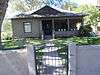 |
February 20, 1991 (#91000030) |
405 Park St. 34°03′17″N 106°53′36″W / 34.054722°N 106.893333°W |
Socorro | |
| 37 | Ilfeld Warehouse | _from_NE_1.JPG) |
August 2, 1982 (#82003332) |
200 N. Main St.[8] 34°07′06″N 107°14′40″W / 34.118302°N 107.244464°W |
Magdalena | |
| 38 | Illinois Brewery | 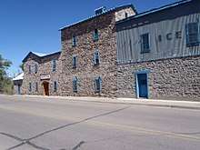 |
September 2, 1975 (#75001173) |
Neal Ave. and 6th St. 34°03′46″N 106°53′25″W / 34.062778°N 106.890278°W |
Socorro | |
| 39 | Lewellen House | _from_NW_1.JPG) |
August 2, 1982 (#82003333) |
2nd and Chestnut Sts. 34°07′03″N 107°14′18″W / 34.117378°N 107.238362°W |
Magdalena | |
| 40 | MacTavish House | _from_NE_1.JPG) |
August 2, 1982 (#82003334) |
302 Elm St.[9] 34°06′51″N 107°14′37″W / 34.114117°N 107.243632°W |
Magdalena | |
| 41 | Magdaline House | _from_SE_1.JPG) |
August 2, 1982 (#82003335) |
3rd and Chestnut Sts. 34°07′01″N 107°14′17″W / 34.116853°N 107.238053°W |
Magdalena | |
| 42 | Main Street Commercial Building | _from_SW_2.JPG) |
August 2, 1982 (#82003336) |
106 N. Main Street[10] 34°07′04″N 107°14′37″W / 34.117698°N 107.243485°W |
Magdalena | |
| 43 | Sagrada Familia de Lemitar Church, Los Dulces Nombres | 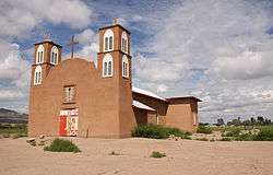 |
February 24, 1983 (#83001631) |
Off Interstate 25 34°09′37″N 106°54′28″W / 34.160278°N 106.907778°W |
Lemitar | |
| 44 | Salinas Pueblo Missions National Monument | 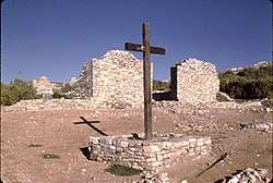 |
October 15, 1966 (#66000494) |
1 mile (1.6 km) east of Gran Quivira on State Road 10 34°15′35″N 106°05′25″W / 34.259722°N 106.090278°W |
Gran Quivira | Extends into Torrance County |
| 45 | Salome Store | August 2, 1982 (#82003337) |
1st St. 34°06′58″N 107°14′42″W / 34.116137°N 107.245094°W |
Magdalena | ||
| 46 | Salome Warehouse | _from_S_1.JPG) |
August 2, 1982 (#82003338) |
1st St. 34°06′59″N 107°14′43″W / 34.116502°N 107.245298°W |
Magdalena | |
| 47 | San Felipe Pueblo Ruin | |
April 25, 1983 (#83001632) |
Address Restricted 33°36′47″N 107°01′33″W / 33.613082°N 107.025726°W |
Socorro | |
| 48 | San Miguel Church | 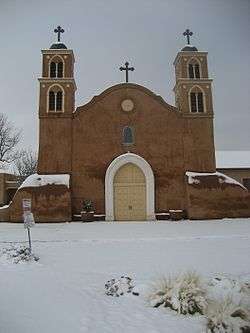 |
April 12, 2016 (#16000162) |
403 El Camino Real St., NW 34°03′37″N 106°53′38″W / 34.060410°N 106.893776°W |
Socorro | |
| 49 | Seco Ruin | |
June 17, 1994 (#94000614) |
Address Restricted |
Chupadera | |
| 50 | Teypama Piro Site | |
October 21, 1983 (#83004179) |
Address Restricted |
Socorro | |
| 51 | Trinity Site | 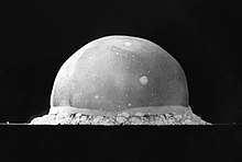 |
October 15, 1966 (#66000493) |
25 miles (40 km) south of U.S. Route 380 on the White Sands Missile Range 33°39′08″N 106°29′34″W / 33.652222°N 106.492778°W |
Bingham | |
| 52 | Val Verde Hotel | 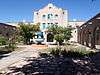 |
September 13, 1977 (#77000930) |
203 Manzanares St. 34°03′28″N 106°53′22″W / 34.057778°N 106.889444°W |
Socorro | |
| 53 | Rufina Vigil House | _from_SE_1.JPG) |
February 20, 1991 (#91000028) |
407 Park St. 34°03′15″N 106°53′39″W / 34.054228°N 106.894232°W |
Socorro | Locally known as "Casa de Flecha"[11] |
Former listings
| [3] | Name on the Register | Image | Date listed | Date removed | Location | City or town | Summary |
|---|---|---|---|---|---|---|---|
| 1 | Severo A. Baca House | January 1, 1999 (#74002268) | Park and Church Sts. 34°03′30″N 106°53′29″W / 34.0583995°N 106.8914159°W |
Socorro | |||
| 2 | MacDonald Merchandise Building | September 25, 1980 (#80002573) | U.S. Highway 60[12] 34°06′58″N 107°14′40″W / 34.116111°N 107.244444°W |
Magdalena | No longer extant[13] |
See also
| Wikimedia Commons has media related to National Register of Historic Places in Socorro County, New Mexico. |
References
- ↑ The latitude and longitude information provided in this table was derived originally from the National Register Information System, which has been found to be fairly accurate for about 99% of listings. For about 1% of NRIS original coordinates, experience has shown that one or both coordinates are typos or otherwise extremely far off; some corrections may have been made. A more subtle problem causes many locations to be off by up to 150 yards, depending on location in the country: most NRIS coordinates were derived from tracing out latitude and longitudes from USGS topographical quadrant maps created under the North American Datum of 1927, which differs from the current, highly accurate WGS84 GPS system used by most on-line maps. Chicago is about right, but NRIS longitudes in Washington are higher by about 4.5 seconds, and are lower by about 2.0 seconds in Maine. Latitudes differ by about 1.0 second in Florida. Some locations in this table may have been corrected to current GPS standards.
- ↑ "National Register of Historic Places: Weekly List Actions". National Park Service, United States Department of the Interior. Retrieved on October 11, 2018.
- 1 2 Numbers represent an ordering by significant words. Various colorings, defined here, differentiate National Historic Landmarks and historic districts from other NRHP buildings, structures, sites or objects.
- ↑ National Park Service (2008-04-24). "National Register Information System". National Register of Historic Places. National Park Service.
- ↑ The eight-digit number below each date is the number assigned to each location in the National Register Information System database, which can be viewed by clicking the number.
- ↑ "Magdalena Public Library". Retrieved 2013-10-02.
- ↑ "Magdalena Historic Walking Tour". Magdalena Chamber of Commerce. Retrieved 2013-10-02. Archived from original Archived 2013-10-24 at the Wayback Machine. 2013-10-24
- ↑ "Magdalena Historic Walking Tour", at Magdalena Chamber of Commerce, retrieved 2013-09-30, archived from original Archived 2013-10-24 at the Wayback Machine. 2013-10-24, gives location as "North Main Street". A street-number plaque on the building, visible left of the front door in this 2013 photo, gives the address as "200".
- ↑ See address on gate in photo
- ↑ The street number is visible in the center of the building in this 2013 photo.
- ↑ "Walking Tour of Historic Socorro". City of Socorro Tourism. Retrieved 2013-09-13.
- ↑ "National Register of Historic Places Inventory—Nomination Form: MacDonald Merchandise Building". Retrieved 2016-03-11.
- ↑ "New Mexico's Rich Cultural Heritage" Archived 2014-11-10 at the Wayback Machine., dated March 2012, issued by New Mexico Historic Preservation Division, retrieved 2016-03-11, p. 51, lists "Magdalena Merchantile Building" as "(REMOVED SR & NR)" [uppercase in original]. According to "National Register of Historic Places Inventory—Nomination Form: MacDonald Merchandise Building", retrieved 2016-03-11, this is another name for the building.
| Topics | |
|---|---|
| Lists by states |
|
| Lists by insular areas | |
| Lists by associated states | |
| Other areas | |
| |
Municipalities and communities of Socorro County, New Mexico, United States | ||
|---|---|---|
| City | | |
| Village | ||
| CDPs | ||
| Other unincorporated communities | ||
| Indian reservations | ||
| Footnotes | ‡This populated place also has portions in an adjacent county or counties | |
This article is issued from
Wikipedia.
The text is licensed under Creative Commons - Attribution - Sharealike.
Additional terms may apply for the media files.