Winston, New Mexico
| Winston, New Mexico | |
|---|---|
| Census-designated place | |
 Winston, New Mexico | |
| Coordinates: 33°20′48″N 107°38′50″W / 33.34667°N 107.64722°WCoordinates: 33°20′48″N 107°38′50″W / 33.34667°N 107.64722°W | |
| Country | United States |
| State | New Mexico |
| County | Sierra |
| Area[1] | |
| • Total | 0.426 sq mi (1.10 km2) |
| • Land | 0.426 sq mi (1.10 km2) |
| • Water | 0 sq mi (0 km2) |
| Elevation | 6,158 ft (1,877 m) |
| Population (2010)[1] | |
| • Total | 61 |
| • Density | 140/sq mi (55/km2) |
| Time zone | UTC-7 (Mountain (MST)) |
| • Summer (DST) | UTC-6 (MDT) |
| ZIP code | 87943 |
| Area code(s) | 575 |
| GNIS feature ID | 912468[2] |
Winston is a census-designated place in Sierra County, New Mexico, United States. Its population was 61 as of the 2010 census.[1] Winston has a post office with ZIP code 87943, which opened on August 15, 1881.[3][4] The community was named for Frank Winston, a pioneer miner.[5] New Mexico State Road 52 passes through the community.
Geography
According to the U.S. Census Bureau, the community has an area of 0.426 square miles (1.10 km2), all of it land.[1]
References
- 1 2 3 4 "2010 Census Gazetteer Files - Places: New Mexico". U.S. Census Bureau. Retrieved August 21, 2014.
- ↑ "Winston". Geographic Names Information System. United States Geological Survey.
- ↑ "Postmaster Finder - Post Offices by ZIP Code". United States Postal Service. Retrieved August 21, 2014.
- ↑ United States Postal Service. "USPS - Look Up a ZIP Code". Retrieved August 21, 2014.
- ↑ Harris, Linda G. (2003). Ghost Towns Alive: Trips to New Mexico's Past. UNM Press. p. 144. ISBN 978-0-8263-2908-0.
External links
Municipalities and communities of Sierra County, New Mexico, United States | ||
|---|---|---|
| Cities | 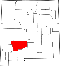 | |
| Villages | ||
| CDPs | ||
| Other communities | ||
| Ghost towns | ||
This article is issued from
Wikipedia.
The text is licensed under Creative Commons - Attribution - Sharealike.
Additional terms may apply for the media files.