National Register of Historic Places listings in San Juan County, New Mexico
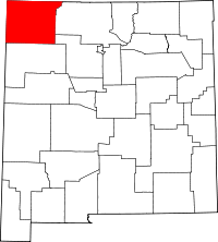
Location of San Juan County in New Mexico
This is a list of the National Register of Historic Places listings in San Juan County, New Mexico.
This is intended to be a complete list of the properties and districts on the National Register of Historic Places in San Juan County, New Mexico, United States. Latitude and longitude coordinates are provided for many National Register properties and districts; these locations may be seen together in a map.[1]
There are 38 properties including 7 districts listed on the National Register in the county. All of the listings within the county with the single exception of the Aztec Ruins Administration Building-Museum are also recorded on the State Register of Cultural Properties.
- This National Park Service list is complete through NPS recent listings posted October 11, 2018.[2]
| Bernalillo – Catron – Chaves – Cibola – Colfax – Curry – De Baca – Doña Ana – Eddy – Grant – Guadalupe – Harding – Hidalgo – Lea – Lincoln – Los Alamos – Luna – McKinley – Mora – Otero – Quay – Rio Arriba – Roosevelt – San Juan – San Miguel – Sandoval – Santa Fe – Sierra – Socorro – Taos – Torrance – Union – Valencia |
Current listings
| [3] | Name on the Register[4] | Image | Date listed[5] | Location | City or town | Description |
|---|---|---|---|---|---|---|
| 1 | H.D. Abrams House | February 21, 1985 (#85000322) |
403 N. Church St. 36°49′31″N 107°59′46″W / 36.825278°N 107.996111°W |
Aztec | ||
| 2 | American Hotel | 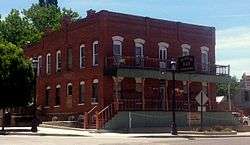 |
February 21, 1985 (#85000323) |
300 S. Main 36°49′07″N 107°59′55″W / 36.818611°N 107.998611°W |
Aztec | |
| 3 | Archeological Site OCA-CGP-56 |  |
February 23, 1978 (#78001822) |
Address Restricted |
Fruitland | |
| 4 | Austin-McDonald House | February 21, 1985 (#85000324) |
501 Rio Grande 36°49′33″N 107°59′27″W / 36.825833°N 107.990833°W |
Aztec | ||
| 5 | Aztec Main Street Historic District | February 21, 1985 (#85000321) |
Bounded by Main E., Chuska S., and alley between Park and Main W., and Chaco N. 36°49′19″N 107°59′54″W / 36.821944°N 107.998333°W |
Aztec | ||
| 6 | Aztec Motor Company Building | 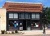 |
February 21, 1985 (#85000325) |
301 S. Main 36°49′08″N 107°59′57″W / 36.818889°N 107.999167°W |
Aztec | |
| 7 | Aztec Ruins Administration Building-Museum | 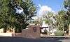 |
October 11, 1996 (#96001041) |
Approximately 0.75 miles north of U.S. Route 550, on the outskirts of Aztec in the Aztec Ruins National Monument 36°50′04″N 107°59′58″W / 36.834444°N 107.999444°W |
Aztec | |
| 8 | Aztec Ruins National Monument | 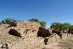 |
October 15, 1966 (#66000484) |
1 mile north of Aztec 36°50′09″N 107°59′51″W / 36.835833°N 107.9975°W |
Aztec | |
| 9 | D.C. Ball House | 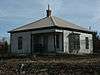 |
February 21, 1985 (#85000326) |
300 San Juan 36°49′26″N 107°59′18″W / 36.823889°N 107.988333°W |
Aztec | |
| 10 | Building at 202 Park Avenue | February 21, 1985 (#85000328) |
202 Park Ave. 36°49′17″N 107°59′58″W / 36.821389°N 107.999444°W |
Aztec | ||
| 11 | Building at 500 White Avenue | February 21, 1985 (#85000327) |
500 White Ave. 36°49′34″N 107°59′31″W / 36.826111°N 107.991944°W |
Aztec | ||
| 12 | Christmas Tree Ruin (LA 11097) | |
January 21, 1987 (#86003646) |
Address Restricted |
Farmington | |
| 13 | Church Avenue-Lovers Lane Historic District | February 21, 1985 (#85000329) |
Bounded by Rio Grande E., Zia S., Park W., and State Road 550 36°49′22″N 107°59′41″W / 36.822778°N 107.994722°W |
Aztec | ||
| 14 | Cottonwood Divide Site (LA 55829) | |
January 21, 1987 (#86003644) |
Address Restricted |
Farmington | |
| 15 | Crow Canyon Archaeological District | 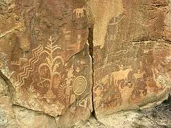 |
July 15, 1974 (#74001200) |
Address Restricted |
Farmington | Extends into Rio Arriba County |
| 16 | Daws-Keys House | February 21, 1985 (#85000330) |
421 N. Church 36°49′32″N 107°59′44″W / 36.825556°N 107.995556°W |
Aztec | ||
| 17 | Denver and Rio Grande Western Railway Depot | February 21, 1985 (#85000331) |
314 Rio Grande 36°49′26″N 107°59′22″W / 36.823889°N 107.989444°W |
Aztec | ||
| 18 | East Side Rincon Site | |
December 15, 1985 (#85003154) |
Address Restricted |
Farmington | |
| 19 | Engleman-Thomas Building | February 21, 1985 (#85000332) |
200 S. Main 36°49′15″N 108°00′07″W / 36.820833°N 108.001944°W |
Aztec | ||
| 20 | Farmington Historic Downtown Commercial District | December 20, 2002 (#02001551) |
Approximately 8 blocks along Main St. and Broadway, from Auburn Ave. to Miller Ave. 36°43′43″N 108°12′22″W / 36.728611°N 108.206111°W |
Farmington | ||
| 21 | Gallegos Wash Archeological District | |
November 20, 1975 (#75001165) |
Address Restricted |
Farmington | |
| 22 | Hadlock's Crow Canyon No. 1 (LA 55830) | |
January 21, 1987 (#86003642) |
Address Restricted |
Farmington | |
| 23 | Halfway House Archeological Site | |
October 10, 1980 (#80002565) |
Address Restricted |
Bloomfield | |
| 24 | Jaquez Site Ruin | |
December 10, 1984 (#84001281) |
Address Restricted |
Farmington | |
| 25 | Lower Animas Ditch | March 19, 1987 (#87001116) |
Lower Animas Ditch from Church Ave. to Lovers Lane Historic District 36°50′32″N 107°58′54″W / 36.842222°N 107.981667°W |
Aztec | ||
| 26 | Harvey McCoy House | February 21, 1985 (#85000333) |
725 Pioneer 36°49′45″N 107°59′37″W / 36.829167°N 107.993611°W |
Aztec | ||
| 27 | McCoy-Maddox House | February 21, 1985 (#85000334) |
Northwestern corner of the junction of Maddox and NE. Aztec Boulevard 36°49′45″N 107°59′21″W / 36.829167°N 107.989167°W |
Aztec | ||
| 28 | McGee House | February 21, 1985 (#85000335) |
501 Sabena St. 36°49′52″N 107°59′20″W / 36.831111°N 107.988889°W |
Aztec | ||
| 29 | Morris' No. 41 Archeological District | |
May 17, 1979 (#79001548) |
Address Restricted |
La Plata | |
| 30 | Florence and John R. Pond House | September 25, 2013 (#13000773) |
1875 NM 170 36°59′23″N 108°11′13″W / 36.989699°N 108.187051°W |
La Plata | ||
| 31 | Prieta Mesa Site (LA 11251) | |
January 21, 1987 (#86003647) |
Address Restricted |
Farmington | |
| 32 | Salmon Ruins | 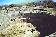 |
September 4, 1970 (#70000406) |
Address Restricted |
Farmington | |
| 33 | San Juan River Bridge at Shiprock | July 15, 1997 (#97000740) |
U.S. Route 666 over the San Juan River 36°46′51″N 108°41′31″W / 36.780833°N 108.691944°W |
Shiprock | ||
| 34 | Simon Canyon (LA 5047) | 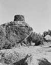 |
January 21, 1987 (#86003645) |
Address Restricted |
Farmington | |
| 35 | Site No. OCA-CGP-54-1 | |
April 19, 1978 (#78001823) |
Address Restricted |
Fruitland | |
| 36 | Site OCA-CGP-605 | |
February 17, 1978 (#78003261) |
Address Restricted |
Fruitland | |
| 37 | Star Rock Refuge (LA 55838) | |
January 21, 1987 (#86003643) |
Address Restricted |
Farmington | |
| 38 | Twin Angels Archeological Site | |
October 10, 1980 (#80002566) |
Address Restricted |
Bloomfield |
See also
| Wikimedia Commons has media related to National Register of Historic Places in San Juan County, New Mexico. |
References
- ↑ The latitude and longitude information provided in this table was derived originally from the National Register Information System, which has been found to be fairly accurate for about 99% of listings. For about 1% of NRIS original coordinates, experience has shown that one or both coordinates are typos or otherwise extremely far off; some corrections may have been made. A more subtle problem causes many locations to be off by up to 150 yards, depending on location in the country: most NRIS coordinates were derived from tracing out latitude and longitudes from USGS topographical quadrant maps created under the North American Datum of 1927, which differs from the current, highly accurate WGS84 GPS system used by most on-line maps. Chicago is about right, but NRIS longitudes in Washington are higher by about 4.5 seconds, and are lower by about 2.0 seconds in Maine. Latitudes differ by about 1.0 second in Florida. Some locations in this table may have been corrected to current GPS standards.
- ↑ "National Register of Historic Places: Weekly List Actions". National Park Service, United States Department of the Interior. Retrieved on October 11, 2018.
- ↑ Numbers represent an ordering by significant words. Various colorings, defined here, differentiate National Historic Landmarks and historic districts from other NRHP buildings, structures, sites or objects.
- ↑ National Park Service (2010-07-09). "National Register Information System". National Register of Historic Places. National Park Service.
- ↑ The eight-digit number below each date is the number assigned to each location in the National Register Information System database, which can be viewed by clicking the number.
| Topics | |
|---|---|
| Lists by states |
|
| Lists by insular areas | |
| Lists by associated states | |
| Other areas | |
| |
Municipalities and communities of San Juan County, New Mexico, United States | ||
|---|---|---|
| Cities | | |
| CDPs |
| |
| Unincorporated communities | ||
| Indian reservations | ||
| Footnotes | ‡This populated place also has portions in an adjacent county or counties | |
This article is issued from
Wikipedia.
The text is licensed under Creative Commons - Attribution - Sharealike.
Additional terms may apply for the media files.