National Register of Historic Places listings in Mora County, New Mexico
Location of Mora County in New Mexico
This is a list of the National Register of Historic Places listings in Mora County, New Mexico.
This is intended to be a complete list of the properties and districts on the National Register of Historic Places in Mora County, New Mexico, United States. Latitude and longitude coordinates are provided for many National Register properties and districts; these locations may be seen together in a map.[1]
There are 23 properties and districts listed on the National Register in the county, including 2 National Historic Landmarks.
- This National Park Service list is complete through NPS recent listings posted October 11, 2018.[2]
| Bernalillo – Catron – Chaves – Cibola – Colfax – Curry – De Baca – Doña Ana – Eddy – Grant – Guadalupe – Harding – Hidalgo – Lea – Lincoln – Los Alamos – Luna – McKinley – Mora – Otero – Quay – Rio Arriba – Roosevelt – San Juan – San Miguel – Sandoval – Santa Fe – Sierra – Socorro – Taos – Torrance – Union – Valencia |
Current listings
| [3] | Name on the Register[4] | Image | Date listed[5] | Location | City or town | Description |
|---|---|---|---|---|---|---|
| 1 | Cassidy Mill | 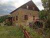 |
December 6, 1978 (#78001818) |
Southeast of Cleveland off State Road 3 35°59′08″N 105°21′29″W / 35.985556°N 105.358056°W |
Cleveland | |
| 2 | Daniel Cassidy and Sons General Merchandise Store | .jpg) |
August 1, 1979 (#79001541) |
State Road 3 35°59′41″N 105°22′16″W / 35.994722°N 105.371111°W |
Cleveland | |
| 3 | Daniel Cassidy House | July 27, 1990 (#90001062) |
Address Restricted |
Mora | ||
| 4 | James J. Cassidy House | September 1, 2005 (#05000943) |
Northeastern corner of the junction of State Road 518 and San Antonio Rd.[6] 35°59′40″N 105°22′13″W / 35.994444°N 105.370278°W |
Cleveland | ||
| 5 | Fort Union National Monument | 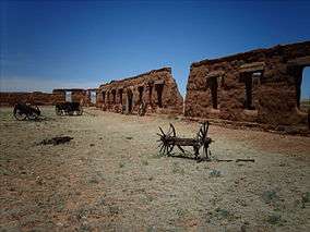 |
October 15, 1966 (#66000044) |
9 miles north of Watrous on State Road 477 35°54′26″N 105°01′06″W / 35.907222°N 105.018333°W |
Watrous | |
| 6 | Garcia House | December 24, 1990 (#90001063) |
Address Restricted |
Mora | ||
| 7 | Gordon-Sanchez Mill | July 27, 1990 (#90001061) |
Address Restricted |
Mora | ||
| 8 | Guadalupita-Coyote Rural Historic District | June 5, 2017 (#100001034) |
Village of Guadalupita, parts of Guadalupita and Williams canyons, and the Coyote Creek valley between Guadalupita and Lucero 36°08′17″N 105°14′17″W / 36.138°N 105.238°W |
Guadalupita | ||
| 9 | La Cueva Historic District | May 25, 1973 (#73001144) |
6 miles southeast of Mora at the junction of State Roads 3 and 21 35°56′34″N 105°14′51″W / 35.942778°N 105.2475°W |
Mora | ||
| 10 | Ledoux Rural Historic District | December 24, 1990 (#90001057) |
Address Restricted |
Ledoux | ||
| 11 | Mora Historic District | December 24, 1990 (#90001056) |
Address Restricted |
Mora | ||
| 12 | North Carmen Historic District | December 24, 1990 (#90001058) |
Address Restricted |
Ledoux | ||
| 13 | Ocate Creek Crossing and the Santa Fe Trail-Mora County Trail Segments | April 21, 1994 (#94000329) |
1.75 miles north of the junction of State Road 127 and the road to Mora Ranch 36°09′02″N 104°54′03″W / 36.150556°N 104.900833°W |
Ocate | ||
| 14 | Jose Olquin Barn-Corral Complex | December 24, 1990 (#90001060) |
Address Restricted |
Mora | ||
| 15 | Santa Clara Hotel | 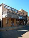 |
May 16, 1991 (#91000602) |
111 Railroad Ave. 36°00′30″N 104°42′22″W / 36.008333°N 104.706111°W |
Wagon Mound | |
| 16 | St. Vrain's Mill | 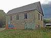 |
August 28, 1973 (#73001143) |
On State Road 38 35°58′32″N 105°19′44″W / 35.975556°N 105.328889°W |
Mora | |
| 17 | J. P. Strong Store | July 27, 1979 (#79001542) |
State Roads 21 and 120 36°10′31″N 105°02′54″W / 36.175278°N 105.048333°W |
Ocate | ||
| 18 | Tipton-Black Willow Ranch Historic District | June 29, 2001 (#00001287) |
3 miles east of Watrous 35°47′28″N 104°55′34″W / 35.791111°N 104.926111°W |
Watrous | ||
| 19 | Desiderio Valdez House | December 24, 1990 (#90001059) |
Address Restricted |
Cleveland | ||
| 20 | Narciso Valdez House | July 11, 1980 (#80004484) |
State Road 120 36°10′34″N 105°02′52″W / 36.176111°N 105.047778°W |
Ocate | ||
| 21 | Valmora Sanatorium Historic District | March 23, 1995 (#95000286) |
State Road 97, 4 miles east of its junction with State Road 161 northeast of Watrous 33°22′56″N 104°55′31″W / 33.382222°N 104.925278°W |
Watrous | ||
| 22 | Wagon Mound | 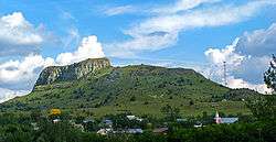 |
October 15, 1966 (#66000478) |
East of Wagon Mound on U.S. Route 85 36°00′39″N 104°42′10″W / 36.010833°N 104.702778°W |
Wagon Mound | |
| 23 | Watrous | .jpg) |
October 15, 1966 (#66000480) |
U.S. Route 85 35°48′03″N 105°00′05″W / 35.800833°N 105.001389°W |
Watrous |
See also
| Wikimedia Commons has media related to National Register of Historic Places in Mora County, New Mexico. |
References
- ↑ The latitude and longitude information provided in this table was derived originally from the National Register Information System, which has been found to be fairly accurate for about 99% of listings. For about 1% of NRIS original coordinates, experience has shown that one or both coordinates are typos or otherwise extremely far off; some corrections may have been made. A more subtle problem causes many locations to be off by up to 150 yards, depending on location in the country: most NRIS coordinates were derived from tracing out latitude and longitudes from USGS topographical quadrant maps created under the North American Datum of 1927, which differs from the current, highly accurate WGS84 GPS system used by most on-line maps. Chicago is about right, but NRIS longitudes in Washington are higher by about 4.5 seconds, and are lower by about 2.0 seconds in Maine. Latitudes differ by about 1.0 second in Florida. Some locations in this table may have been corrected to current GPS standards.
- ↑ "National Register of Historic Places: Weekly List Actions". National Park Service, United States Department of the Interior. Retrieved on October 11, 2018.
- ↑ Numbers represent an ordering by significant words. Various colorings, defined here, differentiate National Historic Landmarks and historic districts from other NRHP buildings, structures, sites or objects.
- ↑ National Park Service (2008-04-24). "National Register Information System". National Register of Historic Places. National Park Service.
- ↑ The eight-digit number below each date is the number assigned to each location in the National Register Information System database, which can be viewed by clicking the number.
- ↑ Location is derived from its NRIS-provided coordinates; the NRIS lists it as "Address Restricted" but provides the coordinates
| Topics | |
|---|---|
| Lists by states |
|
| Lists by insular areas | |
| Lists by associated states | |
| Other areas | |
| |
Municipalities and communities of Mora County, New Mexico, United States | ||
|---|---|---|
| Village | | |
| CDPs | ||
| Other unincorporated communities | ||
This article is issued from
Wikipedia.
The text is licensed under Creative Commons - Attribution - Sharealike.
Additional terms may apply for the media files.