Moselle
| Moselle | |
|---|---|
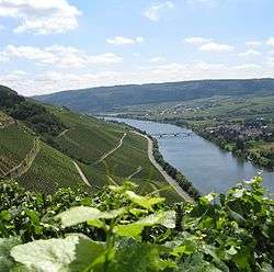 Typical landscape of Moselle vineyards near Schweich | |
| Native name | La Moselle |
| Country | France, Germany, Luxembourg |
| Physical characteristics | |
| Main source |
Vosges mountains 715 m (2,346 ft) |
| River mouth |
Rhine 50°21′58″N 7°36′25″E / 50.36611°N 7.60694°ECoordinates: 50°21′58″N 7°36′25″E / 50.36611°N 7.60694°E |
| Length | 545 km (339 mi) |
| Discharge |
|
| Basin features | |
| Progression | Rhine→ North Sea |
| Basin size | 28,286 km2 (10,921 sq mi) |


%2C_2012-08_CN-01.jpg)
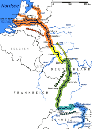
The Moselle (French: la Moselle, IPA: [mɔzɛl]; German: Mosel; Luxembourgish: Musel) is a river flowing through France, Luxembourg, and Germany. It is a left tributary of the Rhine, which it joins at Koblenz. A small part of Belgium is also drained by the Moselle through the Sauer and the Our.
The Moselle "twists and turns its way between Trier and Koblenz along one of Germany's most beautiful river valleys."[1] It flows through a region that has been influenced by mankind since it was first cultivated by the Romans. Today, its hillsides are covered by terraced vineyards where "some of the best Rieslings grow",[1] and numerous ruined castles dominate the hilltops above wine villages and towns that line the riverbanks. Traben-Trarbach with its art nouveau architecture and Bernkastel-Kues with its traditional market square are two of the many popular tourist attractions on the Moselle river.
Name
The name Moselle is derived from the Celtic name form, Moseal, via the Latin Mosella, a diminutive form of Mosa, the Latin description of the Meuse, which used to flow parallel to the Moselle. So the Mosella was the "Little Meuse".
The Moselle is first recorded by Tacitus in Book 13 of his Annals[2] and in Book 4 of his Histories.[3]
The Roman poet, Decimius Magnus Ausonius, made it a literary theme as early as the 4th century. In his poem dated A.D. 371, called Mosella, which was published in 483 hexameters, this poet of the Late Antiquity and teacher at the Trier Imperial Court (Kaiserhof) described a journey from Bingen over the Hunsrück hills to the Moselle and then following its course to Trier on the road named after him, the Via Ausonius. Ausonius describes flourishing and rich landscapes along the river and in the valley of the Moselle, thanks to the policies of their Roman rulers.
The river subsequently gave its name to two French republican départements: Moselle and Meurthe-et-Moselle.
Geography

The source of the Moselle is at 715 metres above sea level on the Col de Bussang on the western slopes of the Ballon d'Alsace in the Vosges. After 544 kilometres it discharges into the Rhine at the Deutsches Eck in Koblenz at a height of 59 metres above NHN. The length of the river in France is 314 kilometres,[4] for 39 kilometres it forms the border between Germany and Luxembourg, and 208 kilometres are solely within Germany.
The Moselle flows through the Lorraine region, west of the Vosges. Further downstream, in Germany, the Moselle valley forms the division between the Eifel and Hunsrück mountain regions.
The average flow rate of the Moselle at its mouth is 328 m³/s,[5] making it the second largest tributary of the Rhine by volume after the Aare (560 m³/s) and bigger than the Main and Neckar.[6]
River sections
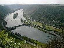
The section of the Moselle from the Franco-German-Luxembourg tripoint to its confluence with the Saar near Konz shortly before Trier is in Germany known (geographically incorrectly) as the Upper Moselle. The section from Trier to Pünderich is the Middle Moselle, the section between Pünderich and its mouth in Koblenz as the Lower Moselle or Terraced Moselle (Terrassenmosel). Characteristic of the Middle and Lower Moselle are its wide meanders cut deeply into the highlands of the Rhenish Massif, the most striking of which is the Cochemer Krampen between Bremm and Cochem. Also typical are its vineyard terraces.
From the tripoint the Moselle marks the entire Saarland-Luxembourg.
Catchment
The catchment area of the Moselle is 28,286 km² in area. The French part covers 15,360 km², about 54 percent of the entire catchment. The German state of Rhineland-Palatinate has 6,980 km², the Saarland 2,569 km², Luxembourg 2,521 km², Wallonia (Belgium) 767 km² and North Rhine-Westphalia, 88 km².
Tributaries
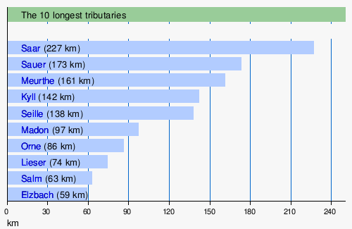
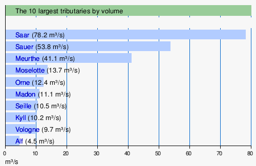
The three largest tributaries of the Moselle are, in order, the Meurthe, the Saar and the Sauer. The Meurthe was the old upper course of the Moselle, until the latter captured the former upper reaches of the Meuse and took it over. However, the Meuse only delivered a little more water than the Meurthe at its confluence. The Saar is the biggest of all the tributaries (78.2 m³/s) as well as the longest (246 km). The Sauer is the largest left-hand tributary and drains the region on either side of the German-Luxembourg border. The largest tributary relative to the Moselle at its confluence is the Moselotte, which is about 40% greater by volumetric flow and thus represents the main branch of the Moselle system. At its mouth, the Mosell delivers 328 m³/s of water into the Rhine after flowing for 544 km.

List of tributaries
From the left: Madon, Terrouin, Esch, Rupt de Mad, Orne, Fensch, Gander, Syre, Sauer, Kyll, Salm, Lieser, Alf, Endert, Brohlbach, Elz.
From the right: Moselotte, Vologne, Meurthe, Seille, Saar, Olewiger Bach, Avelsbach, Ruwer, Feller Bach, Dhron, Ahringsbach, Kautenbach, Lützbach, Flaumbach, Altlayer Bach, Baybach, Ehrbach.
Towns
Towns along the Moselle are:
- in France: Épinal, Toul, Pont-à-Mousson, Metz and Thionville
- in Luxembourg: Schengen, Remich, Grevenmacher and Wasserbillig
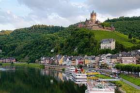
- in Germany: Konz, Trier, Schweich, Bernkastel-Kues, Traben-Trarbach, Zell, Cochem and Koblenz
Adjacent mountain ranges
From Trier downstream the Moselle separates the two Central Upland ranges of the Eifel (to the northwest) and the Hunsrück (to the southeast).
Geology
The Vosges, the present source region of the Moselle, were formed about 50 million years ago. In the Miocene and Pliocene epochs the ancient Moselle (Urmosel) was already a tributary of the ancient Rhine (Ur-Rhein). When, in the Quaternary period, the Rhenish Massif slowly rose, the meanders of the Moselle were formed between the Trier Valley and the Neuwied Basin.
Water levels

The highest navigable water level (HSW) is 695 cm and normal level (NSt) is 200 cm at the Trier Gauge (Pegel Trier).
- 11.28 m, Trier Gauge on 21 December 1993
- 10.56 m, Trier Gauge on 28 May 1983
- 10.33 m, Trier Gauge on 23 January 1995
- 10.26 m, Trier Gauge on 12 April 1983
- 9.92 m, Trier Gauge on 27 February 1997
- 0.47 m in Bernkastel on 28 July 1921
History
The Moselle was known to the Romans by the name of Flumen Musalla (in the Tabula Peutingeriana), and the river was romanticised by the poet Ausonius around 371 A.D. From 1815, the Moselle formed the border between the Grand Duchy of Luxembourg and Prussia (German Empire in 1871).
In the act of 10 April 1952 ratifying the treaty instituted by the E.C.S.C., Article 2 charged the French Government "to initiate, before the establishment of the Common Market, negotiations with the governments concerned in order to achieve a rapid implementation of the canalisation of the Moselle between Thionville and Koblenz.[7][8][9]
The River was canalised between Metz and Thionville, via a canal opened in 1964 by the Grand Duchess, Charlotte of Luxembourg, the Federal Chancellor of Germany, Konrad Adenauer and their host, General de Gaulle, President of France.[10]
It is on the Moselle, at the site of the Franco-German-Luxembourg tripoint, that the Schengen Agreement was signed in 1992, establishing the free movement of goods and people in the European Community.
Economy
The Moselle valley between Metz and Thionville is an industrial area, with coal mining and steel manufactures.
The Moselle valley is famous for its beautiful scenery and the excellent wine produced. Most well-known is the German Mosel wine region, while the Luxembourg winegrowing region is called Moselle Luxembourgeoise and the French region is called AOC Moselle. Most notable among the wines produced here are Riesling, Elbling, Müller-Thurgau, Kerner, and Auxerrois. The German part of the Moselle is a particularly popular tourist destination.
Navigation
After the Second World War, France pressed to be able to ply the Moselle with larger ships in order to be able to link the industrial regions of Lorraine. When, in 1955, the population on the Saar voted to belong to West Germany, France demanded as "compensation" an upgrade of the Moselle. On 27 October 1956 they concluded the Moselle Treaty with Germany and Luxembourg for a canalisation of the Moselle and conceded to Germany in return the extension of the Grand Canal d'Alsace on the Upper Rhine instead of an extension of the canal via Breisach. In 1958 work began and by 26 May 1964 the Moselle could be officially opened from Metz to Koblenz as a major waterway for shipping with 14 locks. France extended it by 1979 as far as Neuves-Maisons. With that, 394 km of the Moselle have been upgraded with a total of 28 locks. In the years 1992 to 1999 the navigable channel was deepened from 2.7 to 3.00 metres, which enables 1500-tonne freighters to use the river, a 20% increase in capacity. The channel has a width of 40 metres, more on the bends. The International Moselle Commission (IMK), founded in 1962 with its head office in Trier, is responsible for navigation. The Moselle Shipping Police Act which it has produced is valid in all three participant states i.e. from Metz to Koblenz.
In 1921 the Moselle (Mo) became a Reich waterway,[11] today it is a federal waterway (Bundeswasserstraße)[12] from Apach at the tripoint to its mouth on the Rhine at kilometre 592.29[13] in Koblenz. The waterway is 242 kilometres[13] long and managed by the Trier and Koblenz Water and Shipping Offices (Wasser- und Schifffahrtsämtern Trier und Koblenz). It is categorized as a European waterway of Class Vb. Its kilometrage begins at its mouth with km 0 and runs upstream. Since 1816 it has formed a 36-km-long[13] condominium from Apach, a common German-Luxembourg sovereign area with a division of responsibilities set out in a 1976 agreement. The International Moselle Company, initially set up in 1957 to finance the construction of the river's upgrade, manages the shipping charges and the operation and maintenance of the waterway which they are used to fund.

Today the Moselle is navigable for large cargo ships up to 110 metres (360 ft) long[14] from the Rhine in Koblenz up to Neuves-Maisons, south of Nancy. For smaller ships it is connected to other parts of France through the Canal de l'Est and the Canal de la Marne au Rhin. There are locks in Koblenz, Lehmen, Müden, Fankel, Sankt Aldegund, Enkirch, Zeltingen, Wintrich, Detzem, Trier, Grevenmacher, Palzem,[14] Apach, Kœnigsmacker, Thionville, Richemont, Talange, Metz, Ars-sur-Moselle, Pagny-sur-Moselle, Blénod-lès-Pont-à-Mousson, Custines, Pompey, Aingeray, Fontenoy-sur-Moselle, Toul, Villey-le-Sec, and Neuves-Maisons.[15]
By 1970 more than 10 million tonnes of goods were being transported on the Moselle, the majority on towed barges. Upstream freight mainly comprised fuel and ores; downstream the main goods were steel products, gravel and rocks. There is an inland port at Trier, a transshipment site in Zell (Mosel); and there are other ports in Mertert, Thionville, Metz and Frouard. In addition to freighters there are also pleasure boats for tourists between the very busy wine villages and small towns of the Middle and Lower Moselle. There are also yachting or sports marinas in the following places: Koblenz, Winningen, Brodenbach, Burgen, Löf, Hatzenport, Senheim, Treis, Traben-Trarbach, Kues, Neumagen, Pölich, Schweich, Trier and Konz. The Moselle is linked near Toul via the Canal de la Marne au Rhin with inter alia the Meuse, the Saône and the Rhône. Other canals link the river to the North Sea and even the Mediterranean.
Locks and dams (weirs)
There is a total of 28 changes of level on the Moselle:
- 16 in France near Neuves-Maisons, Villey-le-Sec, Toul, Fontenoy-sur-Moselle, Aingeray, Frouard-Pompey, Custines, Blénod-lès-Pont-à-Mousson, Pagny-sur-Moselle, Ars-sur-Moselle, Metz, Talange, Richemont, Thionville, Kœnigsmacker and Apach
- 2 between Luxembourg and Germany near Stadtbredimus-Palzem and Grevenmacher-Wellen
- 10 in Germany near Trier, Detzem, Wintrich, Zeltingen, Enkirch, St. Aldegund, Fankel, Müden, Lehmen and Koblenz. Detzem is the highest lock - 9 metres - and at 29 kilometres the upstream reach is the longest on the river; it is the only lock to be built on a canal of some length excavated outside the river bed.
With the exception of Detzem, all the structures at each change in level are laid out side by side; the lock is by one riverbank, the weir in the middle and the hydropower plant on the other bank. Between the lock and weir are a boat slipway/boat channel and boat lock, while between the weir and the power station is the fish ladder. The structures have been blended into the landscape through their low-level design; this was achieved by the choice of sector gates for the weir, vertically lowering upper gates and mitred lower lock gates. The water levels and hydropower works are controlled by the Fankel Central Control Station (Zentralwarte Fankel) of the RWE Power Company at Fankel.
Tourism
Through the Moselle valley run the Moselle Wine Road and the Moselle Cycleway, which may be cycled from Metz in France via Trier to Koblenz on the River Rhine, a distance of 311 kilometres. Between Koblenz and Trier, large sections run on the trackbed of the old Moselle Valley Railway, far from the noise and fumes of motor vehicles. Every year on the Sunday after Pentecost, the 140 kilometres of road between Schweich and Cochem is also car-free as part of the Happy Moselle Day.
A number of notable castles and ruins adorn the heights above the Moselle valley and many are visible on a boat trip on the Moselle.
In 1910, a hiking trail, the Moselle Ridgeway, was established which runs for 185 kilometres on the Eifel side and 262 kilometres on the Hunsrück side. Another unusual trail runs from Ediger-Eller via the Calmont Trail to Bremm through the steepest vineyard in Europe.
Before the construction of barrages the Moselle was a popular route for ustufen beliebter Wanderfluss für folding kayaks which is why many of the weirs have boat channels. The river is still used today by canoeists, especially during the annual week-long lock closures when no commercial shipping is permitted.
In April 2014 the Moselle Trail was opened, a path running for 365 kilometres from Perl on the Upper Moselle to Koblenz. Numerous Moselle Trail "partner trails", the so-called side branches (Seitensprünge) and "dream paths" (Traumpfade) enhance the hiking network in the Moselle Valley.[16]
The ADAC's Rallye Deutschland has taken place since 2000 in the vineyards along the Moselle at Veldenz, Dhron, Piesport, Minheim, Kesten, Trittenheim, Fell, Ruwertal and Trier.
At Koblenz Locks the Mosellum offers exhibitions about the migration of fish in the Moselle as well as water ecology, navigation and power generation. With the construction of the visitor and information centre the most modern fish ladder along the Moselle was opened.
Wine
A wine-growing region lies along the Moselle with a cultivated area of about 10,540 hectares. The largest part, currently just under 9,000 ha, is on German soil in the states of Rhineland-Palatinate and Saarland; the Luxembourg part has an area of about 1,300 hectares (see Wine in Luxembourg). Upstream on the Moselle the vineyards extend into France as far as Seille in the region of Côtes de Moselle with an area of 130 hectares and to the region around Toul (Côtes de Toul) covering 110 hectares.
The German Moselle wine region, including its tributaries, bears the growing and manufacturing name of "Mosel". For marketing reasons the agricultural authorities of the region have divided it into six wine-growing areas.[17] The wine literature and specialist press, by contrast, divide the region into four areas based on geomorphological, micro-climatic and also historical reasons:
1. Upper Moselle. The valley sides of the Upper Moselle (also called the Burgundy Moselle, Burgundermosel) with their overwhelmingly muschelkalk soils belong geologically to the so-called Paris Basin, which explains its low proportion of Riesling - only around 10% in 2010 - and the increasing cultivation of Pinot Blanc and Pinot Noir grapes.
2. Trier Region. Around the city of Trier and in the valleys of the Saar and Ruwer with their side valleys, the Riesling is the predominant grape on the shale soils, with over 80% of the crop. One climatic feature of this area is the frequent orientation of often small southwest-southeast facing locations in which the vegetation is exposed to stronger, cooler winds and, especially in the light of recent global warming, often achieve lower degrees of maturity than in the narrow, often deeply incised valley of the Middle and Lower Moselle.[18]
3. Middle Moselle. With around 6000 hectares of vineyard the Middle Moselle is the largest wine growing area of the Moselle. According to the wine experts and trade, the "greatest" wines of the Moselle, both in quantity and quality, are grown here on land that has been consolidated into large concerns with much vaunted steeply sloped vineyards.[19]
4. Lower Moselle. In the Lower Moselle Valley, the viticulture is more picturesque: with large numbers of medieval castles, high above little villages, decorated with timber-framed houses, surrounded by steep slopes with small terraces in the narrow, winding valley. Here, cultivating vines is very labour-intensive and costly and it is difficult to make it economical. As a result, it is common for vineyards to fall into ruin here.
The wine industry on the German Moselle has been declining for decades. In 2005, statistics showed there were 10,375 hectares of vineyard; by 2012 this had fallen to just 8,491.[20] The vineyards that have fallen fallow are mostly those on extremely steep hillsides. There has been a major decline in the number of so-called Nebenerwerbswinzer (vintners for whom it is a secondary occupation), and the small, family farming operations that, until the end of the 1960s formed the majority of wine businesses. Comparative figures by the Chamber of Agriculture for Rhineland-Palatinate for several wine villages on the Lower Moselle e. g. show that there were still 797 wine businesses in the early 1960s, but by the early 2000s there were only just under 100.
There has been the opposite trend amongst the established traditional wine estates and more recent vintners with a sound education in oenology and business management, who have increased their business through the reclamation of once renowned, but long forgotten sites. The end of the 20th century saw the rediscovery of the use of special terroir[21] in order to improve quality and value, which has led to a more nuanced view of Moselle wine that, a few years before, had been characterised by overproduction, label scandals and cheap offers.
Moselle umbrella brand
On 10 November 2006 in Burg the Moselle Regional Initiative was founded. The introduction of the Moselle as an umbrella brand was based on that of the Eifel region and covers products and services from the areas of agriculture, forestry, tourism, handicrafts and nature.
Moselle Slate
Moselle Slate (Moselschiefer) is a manufacturing and trade description for slate from the municipalities of Mayen, Polch, Müllenbach, Trier and its surrounding area. Today only products from the roofing slate mines of Katzenberg and Margareta in Mayen bear the name Moselle Slate. The name is derived from the historical transport route for this slate along the Moselle to the Lower Rhine. See also: Moselle Slate Road
Literature
The Moselle was celebrated in Mosella, a Latin poem by Ausonius (4th century). In the 20th century, the river and the folklore and local history of the towns along its banks were described by British travel writer Roger Pilkington. In the tale, "The Seven Swabians" of the Brothers Grimm, the eponymous Swabians drown trying to cross the Moselle.
Castles

- Château de Meinsberg (dit de Malbrouck): near Manderen, this castle was built in the 15th century but rebuilt in the 1990s. Today it is used for numerous cultural events.
- Château Fort de Sierck-les-Bains: situated just on the French-German border at Sierck-les-Bains, this fortress of the Duke of Lorraine dates back to the 11th century. Most of today's castle was constructed in the 18th century, following plans from Vauban.
- Schloss Berg: a Renaissance castle at Nennig, today a hotel and a casino.
- Alte Burg: a manor house built in 1360 at Longuich. One of the few surviving manor houses in rural Rhineland-Palatinate.
- Schloss Lieser: a palace at Lieser built from 1884 to 1887 in historistic style.
- Landshut Castle: a castle built by the Electorate of Trier in the 13th century at Bernkastel-Kues.
- Grevenburg: ruins of a castle at Traben-Trarbach built by Johann III of Sponheim-Starkenburg about 1350, destroyed, after many sieges, in 1734.
- Marienburg: a 12th-century castle and later monastery near Pünderich and Alf.
- Arras Castle: a 12th-century castle in Alf.
- Metternich Castle: a castle built around 1120 at Beilstein, today partly in ruins.
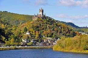
- Cochem Castle: The castle in Cochem was originally built in the 11th century, but was completely destroyed by French soldiers in 1689. The present castle was rebuilt later in the 19th century.
- Thurant Castle: Above the town of Alken is Thurant Castle, built in the 13th century. It is the only twin-towered castle along the Moselle. The fortress was built by the Count Palatine Henry of the house of Guelph between 1198 and 1206. From 1246 to 1248, it was the two archbishops of Cologne and Trier. Following conquest, it was divided by a partition wall into two halves, each with a keep (tower). During the 19th century, Thurant disintegrated, becoming a ruin; and in 1911 was acquired by Privy Councilor, Dr. Robert Allmers, who had it rebuilt. Since 1973, the castle has been owned by the Allmers and Wulf families.[22]
- Ehrenburg: a 12th-century castle built by the Electorate of Trier at Brodenbach.
- Eltz Castle: The von Eltz family castle, whose history dates back to the 12th century. It remains in private hands to this day but it is open to visitors.
- Lower and Upper Castle, Kobern-Gondorf: two 11th-century castles, today mostly in ruins.
- Pyrmont Castle: This 13th-century castle near Roes was remodelled and extended several times during the Baroque era.
- Bischofstein Castle: Across the river from the municipality of Burgen is this 13th-century castle, which was destroyed during the Nine Years' War, but was reconstructed and now serves as a retreat centre for the Fichte Gymnasium in Krefeld.
See also: Wikimedia Commons - Castles in Rhineland-Palatinate
See also
| Wikimedia Commons has media related to Moselle River. |
References
- 1 2 Moselle: Holidays in one of Germany's most beautiful river valleys at www.romantic-germany.info. Retrieved 23 Jan 2016.
- ↑ Publius Cornelius Tacitus: Der Text ist verfügbar in der lateinischen Wikisource: Kapitel LIII, at la.wikisource.org
- ↑ Publius Cornelius Tacitus: Der Text ist verfügbar in der lateinischen Wikisource; erwähnt ist die Mosel in Kapitel 71 und Kapitel 77, at la.wikisource.org
- ↑ Sandre. "Fiche cours d'eau - La Moselle (A---0060)".
- ↑ Hydrologischer Atlas der Schweiz 2002, Tab. 5.4 Natürliche Abflüsse 1961-1980 (natural discharges) (see map Archived 2011-07-07 at the Wayback Machine.)
- ↑ The Meuse, with a volumetric discharge of 350 m³/s is not considered, since it has not officially been a tributary of the Rhine since 1970 (although it is hydrologically).
- ↑ L'historique de la canalisation de la Moselle, par M. René Bour. pp.101 à 112
- ↑ Levainville Jacques, La canalisation de la Moselle. In: Annales de Géographie. 1928, t. 37, n°206. pp. 180-184.
- ↑ "Rivière Moselle - Dictionnaire des canaux et rivières de France". Retrieved 3 May 2016.
- ↑ Institut National de l’Audiovisuel – Ina.fr. "La canalisation de la Moselle". Ina.fr. Retrieved 3 May 2016.
- ↑ Verzeichnis A, Lfd. Nr. 39 der Chronik, Wasser- und Schifffahrtsverwaltung des Bundes, at wsv.de
- ↑ Verzeichnis E, Lfd. Nr. 34 der Chronik, Wasser- und Schifffahrtsverwaltung des Bundes, at wsv.de
- 1 2 3 Gliederung Bundeswasserstraßen, mit Informationen u. a. zu Längen (in km) der Hauptschifffahrtswege (Hauptstrecken und bestimmte Nebenstrecken) der Binnenwasserstraßen des Bundes, bei der Wasser- und Schifffahrtsverwaltung des Bundes, at wsv.de
- 1 2 "Elwis database" (PDF). Archived from the original (PDF) on 2010-10-28. Retrieved 2010-03-17.
- ↑ "DTNE : Direction territoriale Nord-Est VNF". Retrieved 3 May 2016.
- ↑ Moselsteig entfacht das Wanderfieber. In: Trierischer Volksfreund, dated 26 September 2014. Retrieved 26 September 2014, at volksfreund.de
- ↑ Von der Mehrzahl der Winzer nicht genutzte Herkunftsbezeichnung
- ↑ Stuart Pigott, Chandra Kurt, Manfred Lüer: Stuart Pigotts Weinreisen – Mosel. Scherz, Frankfurt am Main, 2009, ISBN 978-3-502-15173-9, pp. 103 ff.
- ↑ Daniel Deckers (Hg.), Zur Lage des deutschen Weins – Spitzenlagen und Spitzenweine, Stuttgart 2003, ISBN 978-3-608-94073-2 pp. 137–187
- ↑ Publications by the Statistical Office of Rhineland-Palatinate.
- ↑ Reinhard Löwenstein, Vom Öchsle zum Terroir, Frankfurter Allgemeine newspaper No. 232, 7 October 2003 and Die Zukunft liegt im Terroir, in the same paper dated 17 December 2005
- ↑ http://www.thurant.de
Bibliography
- Decimius Magnus Ausonius: Mosella [Description of a journey by ship on the Moselle around 371 A. D.]
- Jakob Hölscher (ed.): Das Moselthal von Trier bis Coblenz. In malerischen Ansichten, nach der Natur gezeichnet von C. Bodmer, in acqua tinta geätzt von R. Bodmer. 30 pages. Koblenz, 1831–1833
- Johann August Klein: Moselthal zwischen Koblenz und Konz, printed by Heriot, Coblenz, 1831
- Johann August Klein: Das Moselthal zwischen Koblenz und Zell mit Städten, Ortschaften, Ritterburgen, historisch, topographisch, malerisch. Heriot, Koblenz, 1831
- Wilhelm Haag: Ausonius und seine Mosella. Gaertner, Berlin, 1900
- Michael Gerhard: Die Mosel, dargestellt in ihrem Lauf, ihrer Entstehung und ihrer Bedeutung für den Menschen. Prüm, 1910. Online edition dilibri Rhineland-Palatinate
- Carl Hauptmann: Die Mosel von Cochem bis Bernkastel. Bonn 1910. Online edition dilibri Rhineland-Palatinate
- Carl Hauptmann: Die Mosel von Coblenz bis Cochem in Wanderbildern. Bonn, 1911. Online edition dilibri Rhineland-Palatinate
- Ludwig Mathar: Die Mosel (Die Rheinlande, Bilder von Land, Volk und Kunst, Zweiter Band: Die Mosel) Cologne o. J. (around 1925), 607 S. (with 117 illustrations and a map of the Moselle Valley from Trier to Coblenz)
- Rudolf G. Binding: Moselfahrt aus Liebeskummer – Novelle einer Landschaft, Frankfurt am Main, 1933 (51.–75. Tausend)
- Josef Adolf Schmoll alias Eisenwerth: Die Mosel von der Quelle bis zum Rhein (Deutsche Lande – Deutsche Kunst). 2nd edition, Munich/Berlin, 1972
- Willy Leson (ed.): Romantische Reise durch das Moseltal-Von Koblenz nach Trier (with graphics by Carl Bodmer and text by Johann August Klein and Christian von Stramberg), Cologne, 1978
- Heinz Cüppers, Gérard Collot, Alfons Kolling, Gérard Thill (Red.): Die Römer an Mosel und Saar (Zeugnisse der Römerzeit in Lothringen, in Luxemburg, im Raum Trier und im Saarland), Mainz, 1983, Zabern: 2nd revised edition (with 46 colour and 346 black and white photographs)
- Heinz Held: Die Mosel von der Mündung bei Koblenz bis zur Quelle in den Vogesen: Landschaft, Kultur, Geschichte (DuMont-Kunst-Reiseführer). 3rd edition, Cologne, 1989
- Jean-Claude Bonnefont, Hubert Collin (dir.), Meurthe-et-Moselle, edition Bonneton, Paris, 1996, 318 pages. ISBN 2-86253-203-7
- M. Eckoldt (ed.), Flüsse und Kanäle, Die Geschichte der deutschen Wasserstraßen, DSV-Verlag, 1998
- Ulrich Nonn: Eine Moselreise im 4. Jahrhundert-Decimus Magnus Ausonius und seine "Mosella". In: Koblenzer Beiträge zur Geschichte und Kultur, Vol. 8, Koblenz: Görres-Verlag 2000, pp. 8–24 (with map and illustrations)
- Reinhold Schommers: Die Mosel (DuMont-Reise-Taschenbücher). DuMont, Ostfildern 2001, ISBN 3-7701-3741-8
- Ludwin Vogel: Deutschland, Frankreich und die Mosel. Europäische Integrationspolitik in den Montan-Regionen Ruhr, Lothringen, Luxemburg und der Saar. Klartext, Essen, 2001, ISBN 3-89861-003-9
- Decimius Magnus Ausonius: Mosella. Lateinisch-deutsch. Published, translated and commented on by Paul Dräger. Tusculum Studienausgaben. Artemis und Winkler, Düsseldorf, 2004, ISBN 3-7608-1380-1
- Uwe Anhäuser: Die Ausoniusstraße. Ein archäologischer Reise- und Wanderführer. Rhein-Mosel, Alf/Mosel, 2006, ISBN 3-89801-032-5
- Karl-Josef Gilles: Das Moseltal zwischen Koblenz und Trier 1920 bis 1950 (series of archive photographs), Sutton, Erfurt, 2006, ISBN 978-3-89702-943-9.
- Wasser- und Schifffahrtsdirektion Südwest: Kompendium der Wasser- und Schifffahrtsdirektion Südwest. Organisatorische und technische Daten, Binnenschifffahrt, Aufgaben, Wasserstraßen. self-publication, Mainz, June 2007
- Alexander Thon / Stefan Ulrich: Von den Schauern der Vorwelt umweht... Burgen und Schlösser an der Mosel. Schnell + Steiner, Regensburg 2007, 1st edition, 180 pp. numerous photographs, 2 overview maps of the Moselle
- Wolfgang Lambrecht: Malerische Mosel – Gemälde und Druckgraphik aus 100 Jahren, [Farbbroschüre mit Werken u. a. von Carl Bodmer, Clarkson Stanfield, Rowbotham, Compton, Wolfsberger, Benekkenstein, Burger, Thoma, Nonn, Möhren, Zysing und Bayer, published by the Sparkasse Mittelmosel and the Lions-Förderverein Cochem], Cochem, 2007
- Karl-Josef Schäfer und Wolfgang Welter: Ein Jakobsweg von Koblenz-Stolzenfels nach Trier. Der Pilgerwanderführer für den Mosel-Camino. Books on Demand, Norderstedt, 2009 (2nd updated edition) ISBN 978-3-8334-9888-6
- Xavier Deru: Die Römer an Maas und Mosel, Zabern-Verlag, Mainz, 2010
- Groben, Josef: Mosella. Historisch-kulturelle Monographie, Trier, 2011, 311 pp., 237 photographs.
- Stefan Barme: Nacktarsch, Viez und Ledertanga – Ausflüge in die Kulturgeschichte des Mosellandes. Stephan Moll Verlag, 2012 (1st edition) ISBN 978-3-940760-37-1
- Joachim Gruber: Decimus Magnus Ausonius, <<Mosella>> Kritische Ausgabe, Übersetzung, Kommentar. Walter de Gruyter, Berlin. Series: Texts and commentaries, Vol. 42, 2013, XI, 370 pp.
External links
- mosel.de, mosel.de
- Die Mosel, die-mosel.de
- Moseltal, moseltal.de
- www.mosel.com, mosel.com
- HoloGuides - Moselle, hologuides.com
- River Moselle guide to the French section; maps and information on places, ports and moorings on the river from Neuves-Maisons to Apach, by the author of Inland Waterways of France, Imray
- Navigation details for 80 French rivers and canals (French waterways website section)
- Bibliography on Water Resources and International Law Peace Palace Libray at ppl.nl
- Livecam Moselle river, webcam.cochem.c
- German-Luxembourgish-French Mosel Agency (in German/French)
- German Waterways Agency Trier (Wasser- und Schifffahrtsamt Trier) (in German)
| Authority control |
|---|