Erft
| Erft | |
|---|---|
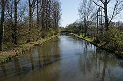 Lower reaches of the Erft near Bergheim | |
| Country |
|
| State | North Rhine-Westphalia |
| Reference no. | DE: 274 |
| Physical characteristics | |
| Main source |
Southeast of Engelgau as the Kuhbach Signed source of the Erft near Holzmülheim 527 m above sea level (NHN) 50°29′14″N 6°35′14″E / 50.48722°N 6.58722°ECoordinates: 50°29′14″N 6°35′14″E / 50.48722°N 6.58722°E |
| River mouth |
Rhine near Neuss-Grimlinghausen 31 m above sea level (NHN) 51°11′04″N 6°43′54″E / 51.18444°N 6.73167°E |
| Length | 106.6 km (66.2 mi) (incl. Kuhbach)[1] |
| Discharge |
|
| Basin features | |
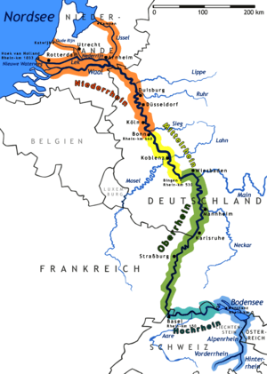
| Progression | Rhine→ North Sea |
| Basin size | 1,837.915 km2 (709.623 sq mi) [1] |
| Landmarks |
|
| Tributaries | |
The Erft (pronounced [ʔɛɐ̯ft]) is a river in North Rhine-Westphalia, Germany. It flows through the foothills of the Eifel, and joins the Lower Rhine (left tributary). Its origin is near Nettersheim, and its mouth in Neuss-Grimlinghausen south of the Josef Cardinal Frings Bridge. The river is 103 kilometres (64 mi) long, which is significantly shorter than it was originally. Due to the open-pit mining of lignite in the Hambacher Loch, the flow of the river had to be changed.
The Erft gave its name to the town of Erftstadt, through which it flows, as well as to the Rhein-Erft district. It also flows through the towns of Bad Münstereifel, Euskirchen, Bergheim, Bedburg and Grevenbroich.
 Source of the Erft near Holzmülheim
 The Erft near Grevenbroich
References
This article is issued from
Wikipedia.
The text is licensed under Creative Commons - Attribution - Sharealike.
Additional terms may apply for the media files.