Mertert
| Mertert Mäertert | ||
|---|---|---|
| Commune | ||
 | ||
| ||
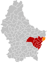 Map of Luxembourg with Mertert highlighted in orange, and the canton in dark red | ||
| Coordinates: 49°42′05″N 6°28′50″E / 49.7014°N 6.4806°ECoordinates: 49°42′05″N 6°28′50″E / 49.7014°N 6.4806°E | ||
| Country |
| |
| Canton | Grevenmacher | |
| Government | ||
| • Mayor | Gust Stefanetti | |
| Area | ||
| • Total | 15.25 km2 (5.89 sq mi) | |
| Area rank | 77 of 102 | |
| Highest elevation | 325 m (1,066 ft) | |
| • Rank | 96th of 102 | |
| Lowest elevation | 132 m (433 ft) | |
| • Rank | 1st of 102 | |
| Population (2014) | ||
| • Total | 4,238 | |
| • Rank | 33rd of 102 | |
| • Density | 280/km2 (720/sq mi) | |
| • Density rank | 26th of 102 | |
| Time zone | UTC+1 (CET) | |
| • Summer (DST) | UTC+2 (CEST) | |
| LAU 2 | LU00007007 | |
| Website | mertert.lu | |

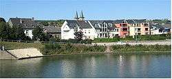
Mertert (Luxembourgish: Mäertert) is a commune and town in eastern Luxembourg, on the border with Germany. It is part of the canton of Grevenmacher, which is part of the district of Grevenmacher. The commune consists of the towns of Mertert and Wasserbillig. Mertert has a river port on the Moselle, the largest in Luxembourg. The commune's administrative centre is Wasserbillig.
As of 2005, the town of Mertert, which lies in the south of the commune, has a population of 1,101. Another town within the commune is Wasserbillig.
External links

Places adjacent to Mertert | ||||||||||
|---|---|---|---|---|---|---|---|---|---|---|
| ||||||||||
 | ||
This article is issued from
Wikipedia.
The text is licensed under Creative Commons - Attribution - Sharealike.
Additional terms may apply for the media files.