Grevenmacher
| Grevenmacher Gréiwemaacher | ||
|---|---|---|
| Commune | ||
 | ||
| ||
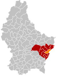 Map of Luxembourg with Grevenmacher highlighted in orange, and the canton in dark red | ||
| Coordinates: 49°40′50″N 6°26′30″E / 49.6806°N 6.4417°ECoordinates: 49°40′50″N 6°26′30″E / 49.6806°N 6.4417°E | ||
| Country |
| |
| Canton | Grevenmacher | |
| Government | ||
| • Mayor | Léon Gloden | |
| Area | ||
| • Total | 16.48 km2 (6.36 sq mi) | |
| Area rank | 72nd of 102 | |
| Highest elevation | 315 m (1,033 ft) | |
| • Rank | 99th of 102 | |
| Lowest elevation | 133 m (436 ft) | |
| • Rank | 2nd of 102 | |
| Population (2014) | ||
| • Total | 4,647 | |
| • Rank | 30th of 102 | |
| • Density | 280/km2 (730/sq mi) | |
| • Density rank | 25th of 102 | |
| Time zone | UTC+1 (CET) | |
| • Summer (DST) | UTC+2 (CEST) | |
| LAU 2 | LU00007004 | |
| Website | grevenmacher.lu | |

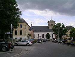
Grevenmacher (Luxembourgish: Gréiwemaacher) is a commune with town status in eastern Luxembourg, near the border with Germany. It is the capital of the canton and the district of Grevenmacher. The town is situated on the left bank of the Moselle River, in a wine growing region.
As of 2005, the town of Grevenmacher, which lies in the east of the commune, has a population of 3,734.
The town is the site of one of the six regional headquarters of the Grand Ducal Police.
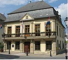
The old Town Hall
Twin towns
See also
External links
| Wikivoyage has a travel guide for Grevenmacher. |

Places adjacent to Grevenmacher | ||||||||||
|---|---|---|---|---|---|---|---|---|---|---|
| ||||||||||
 | ||
| Authority control |
|---|
This article is issued from
Wikipedia.
The text is licensed under Creative Commons - Attribution - Sharealike.
Additional terms may apply for the media files.