Düssel
| Düssel | |
|---|---|
 | |
 The delta of the Düssel | |
| Country | Germany |
| Physical characteristics | |
| Main source | Bergisches Land |
| River mouth |
Rhine 51°13′38″N 6°46′13″E / 51.2271°N 6.7704°ECoordinates: 51°13′38″N 6°46′13″E / 51.2271°N 6.7704°E |
| Length | 36.0 km (22.4 mi) [1] |
| Basin features | |
| Progression | Rhine→ North Sea |
| Basin size | 163 km2 (63 sq mi) [1] |

Quelle der Düssel in Wülfrath

Düsselquelle in Wülfrath
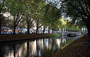
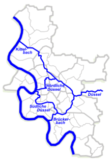
The Düssel is a small right tributary of the river Rhine in North Rhine Westphalia, Germany. Its source is east of Wülfrath. It flows westward through the Neander Valley where the fossils of the first Neanderthal man were found in August 1856. At Düsseldorf it forms a river delta by splitting into four streams (Nördliche Düssel, Südliche Düssel, Kittelbach, Brückerbach), which all join the Rhine after a few kilometres. The Nördliche Düssel flows through the Hofgarten and passes under the Golden Bridge.[2]
Düsseldorf takes its name from the Düssel: Düsseldorf means "the village of Düssel". The name Düssel itself probably dates back to the Germanic *thusila and means "roar" (Old High German doson, German tosen).
See also
References
- 1 2 Hydrographic Directory of the NRW State Office for Nature, the Environment and Consumer Protection (Gewässerverzeichnis des Landesamtes für Natur, Umwelt und Verbraucherschutz NRW 2010) (xls; 4.67 MB)
- ↑ Dohmen, Nele (7 May 2018). "Hofgarten: Baustelle bleibt bis Herbst". Westdeutsche Zeitung. Retrieved 18 August 2018.
This article is issued from
Wikipedia.
The text is licensed under Creative Commons - Attribution - Sharealike.
Additional terms may apply for the media files.