Marne–Rhine Canal
| Canal de la Marne au Rhin | |
|---|---|
 The Marne-Rhine Canal at Niderviller, Moselle | |
| Specifications | |
| Length | 313 km (194 mi) |
| Locks | 154 (originally 178) |
| History | |
| Construction began | 1838 |
| Date completed | 1853 |
| Geography | |
| Start point | Canal latéral à la Marne in Vitry-le-François |
| End point | Rhine in Strasbourg |
| Beginning coordinates | 48°43′48″N 4°36′24″E / 48.730123°N 4.606670°E |
| Ending coordinates | 48°35′26″N 7°47′16″E / 48.590661°N 7.787779°E |
| Connects to | Canal latéral à la Marne, Canal entre Champagne et Bourgogne, Canal de la Meuse, Moselle River, Canal de la Sarre, Rhine |
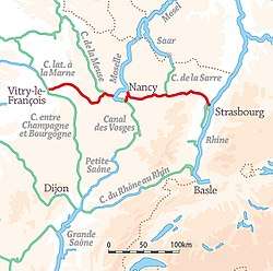
The Canal de la Marne au Rhin (Marne-Rhine Canal) is a canal in north-eastern France. It connects the river Marne and the Canal entre Champagne et Bourgogne in Vitry-le-François with the port of Strasbourg on the Rhine. The original objective of the canal was to connect Paris and the north of France with Alsace and Lorraine, the Rhine, and Germany.[1] The 313 km (194 mi) long canal was the longest in France when it opened in 1853.[2]
Description
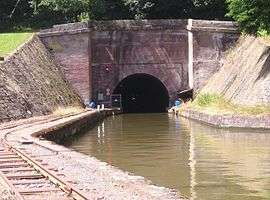
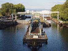
The canal is suited for small barges (péniches), with a maximum size of 38.50 metres (126.3 ft) in length and 5.05 metres (16.6 ft) in width. It has 154 locks, including two in the Moselle River. There are four tunnels. The Saint-Louis-Arzviller inclined plane is located between Arzviller and Saint-Louis and its construction replaced 17 locks.[1]
In 1979, a 23 kilometres (14 mi) section along the Moselle valley was closed following completion of the Moselle canalisation works between Frouard and Neuves-Maisons. The route is now made up as follows:
- Canal de la Marne au Rhin, western section (PK 0-131), connecting with the Canal de la Meuse at Troussey (PK 111), and with a branch to Houdelaincourt (PK 85),
- the navigable river Moselle from Toul to Pompey and the Frouard branch from Pompey to Frouard (a distance of 25km, slightly longer than by the original canal),
- the eastern section, from Frouard to Strasbourg (PK 154-313); this section connects with the Nancy branch at Laneuveville-devant-Nancy (PK 169), the Canal de la Sarre at Gondrexange (PK 228), and the River Ill in Strasbourg (PK 311).[2]
The western section, 131.4 km (81.6 mi) has 97 locks, 70 rising to the summit level and 27 down to the Moselle at Toul. The Moselle section has three locks of high-capacity Rhine dimensions on the river and one on the Frouard branch, and an additional Freycinet size lock connecting to the original canal in Frouard. The eastern section, 159 km (99 mi), has 56 locks, 21 rising to the summit level crossing the Vosges watershed and 35 down to Strasbourg.[2]
Its course crosses the following départements and towns:
- Marne: Vitry-le-François
- Meuse: Bar-le-Duc, Ligny-en-Barrois, Void-Vacon
- Meurthe-et-Moselle: Toul, Nancy
- Moselle: Gondrexange, Sarrebourg
- Bas-Rhin: Saverne, Strasbourg
En Route
See also
References
External links
- Canal de la Marne au Rhin with maps and detailed information on places, ports and moorings on the canal, by the author of Inland Waterways of France, Imray
- Navigation details for 80 French rivers and canals (French waterways website section)
| Authority control |
|---|