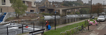
Weir

A weir /wɪər/ or low head dam is a barrier across the horizontal width of a river that alters the flow characteristics of water and usually results in a change in the height of the river level. There are many designs of weir, but commonly water flows freely over the top of the weir crest before cascading down to a lower level.
Etymology
There is no single definition as to what constitutes a weir and one English dictionary simply defines a weir as a small dam, likely originating from Middle English were, Old English wer, derivative of root of werian, meaning "to defend, dam".[1][2]
Function
Weirs are commonly used to prevent flooding, measure water discharge, and help render rivers more navigable by boat. In some locations, the terms dam and weir are synonymous, but normally there is a clear distinction made between the structures. A dam is usually specifically designed to impound water behind a wall, whilst a weir is designed to alter the river flow characteristics.
A common distinction between dams and weirs is that water flows over the top (crest) of a weir or underneath it for at least some of its length. Accordingly, the crest of an overflow spillway on a large dam may therefore be referred to as a weir. Weirs can vary in size both horizontally and vertically, with the smallest being only a few inches in height whilst the largest may be hundreds of metres long and many metres tall. Some common weir purposes are outlined below.
Flow measurement
Weirs allow hydrologists and engineers a simple method of measuring the volumetric flow rate in small to medium-sized streams/rivers or in industrial discharge locations. Since the geometry of the top of the weir is known and all water flows over the weir, the depth of water behind the weir can be converted to a rate of flow. However, this can only be achieved in locations where all water flows over the top of the weir crest (as opposed to around the sides or through conduits/sluices) and at locations where the water that flows over the crest is carried away from the structure. If these conditions are not met, it can make flow measurement complicated, inaccurate or even impossible.
The discharge calculation can be summarised as:

Where:
- Q is the volumetric flow rate of fluid (the discharge)
- C is the flow coefficient for the structure (on average a figure of 0.62).
- L is the width of the crest
- H is the height of head of water over the crest
- n varies with structure (e.g., 3/2 for horizontal weir, 5/2 for v-notch weir)
However, this calculation is a generic relationship and specific calculations are available for the many different types of weir. Flow measurement weirs must be well maintained if they are to remain accurate.[3][4]
Control of invasive species
As weirs are a physical barrier they can impede the longitudinal movement of fish and other animals up and down a river. This can have a negative effect on fish species that migrate as part of their breeding cycle (e.g., salmonids), but can also be useful as a method of preventing invasive species moving upstream. For example, weirs in the Great Lakes region have helped to prevent invasive sea lamprey from colonising further upstream.
Watermills
Mill ponds are created by a weir that impounds water that then flows over the structure. The energy created by the change in height of the water can then be used to power waterwheels and power sawmills, grinding wheels and other equipment.
Flood control and altering river conditions
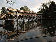
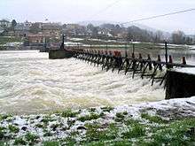
Weirs are commonly used to control the flow rates of rivers during periods of high discharge. Sluice gates (or in some cases the height of the weir crest) can be altered to increase or decrease the volume of water flowing downstream. Weirs for this purpose are commonly found upstream of towns and villages and can either be automated or manually operated. By slowing the rate at which water moves downstream even slightly a disproportionate effect can be had on the likelihood of flooding. On larger rivers, a weir can also alter the flow characteristics of the waterway to the point that vessels are able to navigate areas previously inaccessible due to extreme currents or eddies. Many larger weirs will have features built in that allow boats and river users to "shoot the weir" and navigate by passing up or down stream without having to exit the river. Weirs constructed for this purpose are especially common on the River Thames, and most are situated near each of the river's 45 locks.
Issues
Ecology
Because a weir impounds water behind it and alters the flow regime of the river, it can have an effect on the local ecology. Typically the reduced river velocity upstream can lead to increased siltation (deposition of fine particles of silt and clay on the river bottom) that reduces the water oxygen content and smothers invertebrate habitat and fish spawning sites. The oxygen content typically returns to normal once water has passed over the weir crest (although it can be hyper-oxygenated), although increased river velocity can scour the river bed causing erosion and habitat loss.
Fish migration
Weirs can have a significant effect on fish migration.[5] Any weir that exceeds either the maximum height a species can jump or creates flow conditions that cannot be bypassed (e.g., due to excessive water velocity) effectively limits the maximum point upstream that fish can migrate. In some cases this can mean that huge lengths of breeding habitat are lost and over time this can have a significant impact of fish populations.
In many countries, it is now a requirement by law to build fish ladders into the design of a weir that ensures that fish can bypass the barrier and access upstream habitat. Unlike dams, weirs do not usually prevent downstream fish migration (as water flows over the top and allows fish to bypass the structure), although they can create flow conditions that injure juvenile fish. Recent studies suggest that navigation locks have also potential to provide increased access for a range of biota, including poor swimmers.[6]
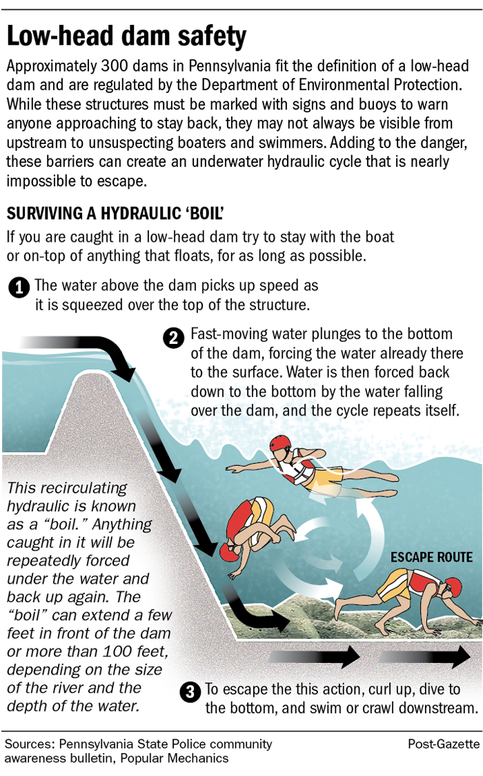
Safety
Even though the water around weirs can often appear relatively calm, they can be extremely dangerous places to boat, swim, or wade, as the circulation patterns on the downstream side—typically called a hydraulic jump— can submerge a person indefinitely. This phenomenon is so well known to canoeists, kayakers, and others who spend time on rivers that they even have a rueful name for weirs: "drowning machines".[7] If caught in this situation, the Ohio DNR recommends that a victim should "tuck the chin down, draw the knees up to the chest with arms wrapped around them. Hopefully, conditions will be such that the current will push the victim along the bed of the river until swept beyond the boil line and released by the hydraulic."[8] The Pennsylvania State Police also recommends to "curl up, dive to the bottom, and swim or crawl downstream".[9] As the hydraulic entrains air, the buoyancy of the water between the dam and boil line will be reduced by upwards of 30%, and if a victim is unable to float, escape at the base of the dam may be the only option for survival.
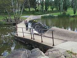
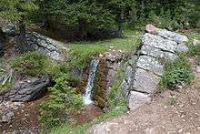
Common types


There are many different types of weirs and they can vary from a simple stone structure that are barely noticeable, to elaborate and very large structures that require extensive management and maintenance.
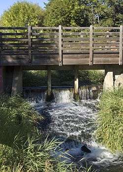
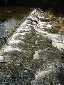
Broad-crested
A broad-crested weir is a flat-crested structure, where the water passes over a crest that covers much or all of the channel width. This is one of the most common types of weir found worldwide.
Compound
A compound weir is any weir that comprises several different designs into one structure. They are commonly seen in locations where a river has multiple users who may need to bypass the structure. A common design would be one where a weir is broad-crested for much of its length, but has a section where the weir stops or is 'open' so that small boats and fish can traverse the structure.
V-notch
A notch weir is any weir where the physical barrier is significantly higher than the water level except for a specific notch (often V-shaped) cut into the panel. At times of normal flow all the water must pass through the notch, simplfiying flow volume calculations, and at times of flood the water level can rise and submerge the weir without any alterations made to the structure.
Polynomial
A polynomial weir[10] is a weir that has a geometry defined by a polynomial equation of any order n. Most weirs in practice are low-order polynomial weirs. The standard rectangular weir is, for example, a polynomial weir of order zero. The triangular (V-notch) and trapezoidal weirs are of order one. High-order polynomial weirs are providing wider range of Head-Discharge relationships, and hence better control of the flow at outlets of lakes, ponds, and reservoirs.
See also
References
Notes
- ↑ "the definition of weir". Dictionary.com. Archived from the original on 2017-03-04. Retrieved 2017-03-03.
- ↑ "Weir". www.etymonline.com. Online Etymology Dictionary. Archived from the original on 19 March 2017. Retrieved 20 May 2017.
- ↑ "Weirs - Flow Rate Measure". www.engineeringtoolbox.com. Archived from the original on 2017-03-04. Retrieved 2017-03-03.
- ↑ "Factors affecting weir flow measurement accuracy". openchannelflow.com. Archived from the original on 30 July 2016. Retrieved 2 May 2018.
- ↑ Tummers, J. S., Winter, E., Silva, S., O’Brien, P., Jang, M. H., & Lucas, M. C. (2016). Evaluating the effectiveness of a Larinier super active baffle fish pass for European river lamprey Lampetra fluviatilis before and after modification with wall-mounted studded tiles. Ecological Engineering, 91, 183-194.
- ↑ Silva, S., Lowry, M., Macaya-Solis, C., Byatt, B., & Lucas, M. C. (2017). Can navigation locks be used to help migratory fishes with poor swimming performance pass tidal barrages? A test with lampreys. Ecological Engineering, 102, 291-302.
- ↑ Michael Robinson; Robert Houghtalen. "Dangerous dams". Rhode Island Canoe/Kayak Association. Rhode Island. Archived from the original on 2010-08-12. Retrieved 2011-06-26.
- ↑ Boating, Ohio DNR Division of Parks and Watercraft -. "Lowhead Dam Safety". watercraft.ohiodnr.gov. Archived from the original on 30 November 2016. Retrieved 2 May 2018.
- ↑ "Archived copy". Archived from the original on 2018-05-02. Retrieved 2017-06-15. Escaping a low-head dam
- ↑ Baddour, R.E. (2008). "Head-Discharge Equation for Sharp-Crested Polynomial Weir". ASCE J. Irrigation and Drainage Engineering. 134 (2): 260–262.
Works cited
Bibliography
- Chanson, H. (2004). "The Hydraulics of Open Channel Flow : An Introduction." Butterworth-Heinemann, Oxford, UK, 2nd edition, 630 pages ( ISBN 978 0 7506 5978 9).
- Chanson, H. (2007). Hydraulic Performances of Minimum Energy Loss Culverts in Australia, Journal of Performances of Constructed Facilities, ASCE, Vol. 21, No. 4, pp. 264–272 doi:10.1061/(ASCE)0887-3828(2007)21:4(264).
- Gonzalez, C.A., and Chanson, H. (2007). Experimental Measurements of Velocity and Pressure Distribution on a Large Broad-Crested Weir, Flow Measurement and Instrumentation, 18 3-4: 107-113 doi:10.1016/j.flowmeasinst.2007.05.005.
- Henderson, F.M. (1996), Open Channel Flow, New York, USA.: MacMillan Company
- McKay, G.R. (1971). "Design of Minimum Energy Culverts." Research Report, Dept of Civil Eng., Univ. of Queensland, Brisbane, Australia, 29 pages & 7 plates.
- Sturm, T.W. (2001). "Open Channel Hydraulics." McGraw Hill, Boston, USA, Water Resources and Environmental Engineering Series, 493 pages.
External links
| Wikimedia Commons has media related to Weirs. |
| Look up weir in Wiktionary, the free dictionary. |
- Hydraulics of Minimum Energy Loss (MEL) culverts and bridge waterways (Click "proceed" at the UQ-ITS Advisory webapge)