Weschnitz
| Weschnitz | |
|---|---|
 The course of the Weschnitz. | |
| Physical characteristics | |
| Main source |
455 m (1,493 ft) 49°38′22.4″N 8°49′43.1″E / 49.639556°N 8.828639°E |
| River mouth |
84.9 m (279 ft) 49°42′39″N 8°24′36″E / 49.71083°N 8.41000°ECoordinates: 49°42′39″N 8°24′36″E / 49.71083°N 8.41000°E |
| Length | 59.4 km (36.9 mi) [1] |
| Basin features | |
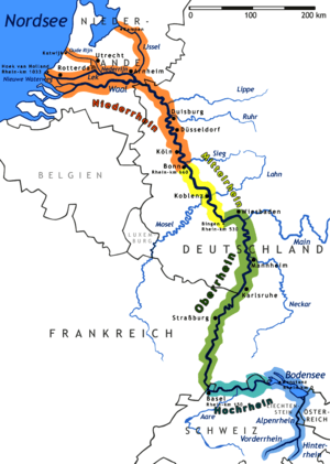
| Progression | Rhine→ North Sea |
| Basin size | 438.3 km2 (169.2 sq mi) [1] |
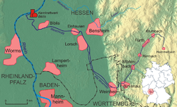
The Weschnitz is a 59.4 km long right tributary of the Rhine River running through the German states of Hesse and Baden-Württemberg. The name of the river traces to the Celtic god Visucius, who was worshiped in the region.
The river source is in the Odenwald, in the town of Grasellenbach. It then flows in a westerly direction through a number of communities, including Fürth, Rimbach, Mörlenbach and Birkenau. At Weinheim, the river splits into two branches as it enters the Upper Rhine Plain. The two courses join at Lorsch. It then flows through the communities of Einhausen and Biblis before emptying into the Rhine at the Biblis Nuclear Power Plant.
References
This article is issued from
Wikipedia.
The text is licensed under Creative Commons - Attribution - Sharealike.
Additional terms may apply for the media files.