Marathwada
| Marathwada | |
|---|---|
 | |
| Districts |
Aurangabad, Beed, Hingoli, Jalna, Latur, Nanded, Osmanabad, Parbhani |
| Largest cities | Aurangabad |
| Divisions | Aurangabad division |
| Area | 64,590 km2 (24,940 sq mi) |
| Population (2011) | 18,731,872[1] |
| Density (per km²) | 354[1] |
| Literacy | 76.27%[1] |
| Sex Ratio | 932[1] |
Marathwada (IPA:Marāṭhvāḍā) is a region of the Indian state of Maharashtra. The region coincides with the Aurangabad Division of Maharashtra. It borders the states of Karnataka and Telangana, and it lies to the west of the Vidarbha and east of Khandesh regions of Maharashtra. The largest city of Marathwada is Aurangabad. Its people speak Marathi and Dakhini.
Etymology
The term Marathwada means the house of Marathi people, that is land occupied by the Marathi-speaking population of the former Hyderabad state during the period of Nizam rule. The term can be traced to 18th century state records of the Nizam of Hyderabad.[2]
Demography
Marathwada has total area of 64590 km2 and had a population of 18,731,872 at the 2011 census of India.[3][lower-alpha 1]
Cities and districts
Major cities of Marathwada region include Aurangabad, Nanded-Waghala, Parbhani, Latur, and Jalna
Its district areas are:
There are Municipal Corporations at Aurangabad,[4] Nanded,[5] Latur, and Parbhani.[6]
Tourism


The state government recognises Aurangabad as the "Tourism Capital of Maharashtra".[7] There are various tourist attractions in Aurangabad. Other places visited by tourists are:
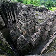
- Ajanta caves
- Ellora caves
- Udgir Fort
- Ausa
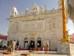
- Hazur Sahib Nanded
- Bibi Ka Maqbara
- Dharashiv Caves
- Aundha Nagnath
- Mahur
- Kandhar
- Deogiri fort / *Daulatabad
- Grishneshwar temple
- Parli
- Tuljapur
- Ambajogai/Yogeshwari
- Dharur, Beed
- Ramling, Yedshi
Education
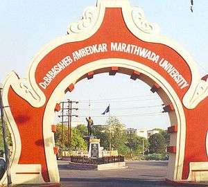
Marathwada has four government medical colleges, situated at Aurangabad, Latur, Nanded and Swami Ramanand Teerth Rural Medical College at Ambajogai. It also has three major universities, being Dr. Babasaheb Ambedkar Marathwada University at Aurangabad, Vasantrao Naik Marathwada Agricultural University at Parbhani, and Swami Ramanand Teerth Marathwada University at Nanded.
Droughts and suicide of farmers
Marathwada is affected by frequent anomalies in rainfall during Monsoon season, which accounts for almost 80 percent of the annual rainfall. The average annual rainfall over the division is 882 mm. Almost three-fourths of the Marathwada division is covered by agricultural lands. Hence, drought is having a significant impact on the life of farmers. [8] According to government records, 422 farmers in Marathwada committed suicide in 2014. This was because of their inability to bear crop losses and a financial quandary made acute by water scarcity and an agrarian crisis.[9] 2014 was the third consecutive year of low rainfall, and when rainfall did occur it was sometimes untimely and damaged crops. Of the 422 suicides, 252 cases were due to an inability to repay agricultural loans. There have been more than 117 farmer suicides in the first two months of 2017. [9] According to a study by IIT Bombay, the severe or extreme droughts have frequently occurred in major portions of Marathwada, in the last few decades.[8]
See also
- List of people from Marathwada
- Make in Maharashtra
- Manav Vikas Mission
References
Notes
- ↑ Marathwada is not separate political or administrative entity so there is no reference of population by name of "Marathwada", population has been calculated by adding population of 8 districts of Marathwada.
Citations
- 1 2 3 4 "District wise Demography". Census 2011. Retrieved 23 May 2015.
- ↑ Kate, P. V. (1987). Marathwada under the Nizams, 1724-1948. Delhi, India: Mittal Publications. p. 3. ISBN 8170990173.
- ↑ "Maharashtra Population Census data 2011". Government of India. Retrieved 11 April 2015.
- ↑ http://www.aurangabadmahapalika.org/singleIndex.jsp?orgid=95
- ↑ "NWCMC Home Page". Nwcmc.gov.in. Retrieved 2015-05-29.
- ↑ http://pcmcparbhani.org/
- ↑ "World News Headlines". Newkerala.com. Retrieved 2015-05-29.
- 1 2 Swain, S; et al. "Application of SPI, EDI and PNPI using MSWEP precipitation data over Marathwada, India". IEEE International Geoscience and Remote Sensing Symposium (IGARSS. 2017: 5505–5507. doi:10.1109/IGARSS.2017.8128250. Retrieved 15 June 2018.
- 1 2 "422 farmer suicides in 2014 in Marathwada gives BJP govt the jitters | Business Standard News". Business-standard.com. 2014-12-05. Retrieved 2015-05-29.
Further reading
- Beyond Economic Development: A Case Study of Marathwada
- Vidarbha and Marathwada: Trapped in a vicious cycle -Hindustan Times
- Cane cultivation leaving Marathwada bone dry: Study -The Times of India
- Photo-essay on the 2016 drought in Marathwada
- Have India's farm suicides really declined? -BBC article
- In worst drought year, Marathwada emerges new suicide region -Indian Express
- ‘Wrong method used to calculate Vidarbha, Marathwada backlog’ - The Times of India
- Lucien D. Benichou (1 January 2000). From Autocracy to Integration: Political Developments in Hyderabad State, 1938-1948. Orient Blackswan. ISBN 978-81-250-1847-6.
- Human Development Report 2002 - Maharashtra (India)
- History of Modern India, Bipin Chandra, Orient Blackswan, 2009
Largest city: Aurangabad Second largest: Nanded | |
| Districts of Marathwada | |
| Cities with municipal corporations | |
| Topics | |
Portal: Maharashtra | |
| Topics | |||||||||||||
|---|---|---|---|---|---|---|---|---|---|---|---|---|---|
| Regions | |||||||||||||
| Divisions and Districts |
| ||||||||||||
| Million-plus cities in Maharashtra | |||||||||||||
| Other cities with municipal corporations | |||||||||||||
Portal: Maharashtra | |||||||||||||