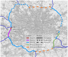
M25 motorway
| ||||
|---|---|---|---|---|
_map.svg.png) | ||||
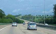
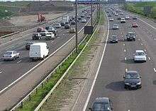
 Aerial view of junction 13 looking south | ||||
| Route information | ||||
|
Part of | ||||
| Maintained by Highways England | ||||
| Length | 117 mi (188 km) | |||
| Existed | 1975 – present | |||
| History |
Opened: 1975 Completed: 1986 | |||
| Major junctions | ||||
| Orbital around London (in conjunction with the A282) | ||||
| South end | Darenth | |||
|
J3 → M20 motorway J5 → M26 motorway J7 → M23 motorway J12 → M3 motorway J15 → M4 motorway J16 → M40 motorway J21 → M1 motorway J23 → A1(M) motorway J27 → M11 motorway | ||||
| North end | Aveley | |||
| Location | ||||
| Counties | Kent, Surrey, Berkshire, Greater London, Buckinghamshire, Hertfordshire, Essex | |||
| Primary destinations |
London Sevenoaks Reigate Staines-upon-Thames Heathrow Airport Watford St Albans Enfield | |||
| Road network | ||||
| ||||

The M25 or London Orbital Motorway is a 117-mile (188 km) motorway that encircles almost all of Greater London, England (with the exception of North Ockendon), in the United Kingdom. An ambitious concept to build four concentric ring roads around London was first mooted in the 1960s. A few sections of the outer two rings were constructed in the early 1970s, but the plan was abandoned and the sections were later integrated to form a single ring which became the M25, aka London Ring Road, finally completed in 1986.
It is one of the busiest of the British motorway network: 196,000 vehicles were recorded on a busy day near Heathrow Airport in 2003[1] and the western half experienced an average daily flow of 147,000 vehicles in 2007.[2]
The M25, plus the short non-motorway A282 which joins the two ends of the M25 across the River Thames using the Dartford Crossing, is Europe's second longest orbital road after the Berliner Ring, which is 122 miles (196 km).
Description
_AN1572653.jpg)
Originally built almost wholly as a dual three-lane motorway, much of the motorway has been widened: to dual four lanes for almost half, to a dual five-lanes section between junctions 12 and 14 and a dual six-lane section between junctions 14 and 15. Further widening is in progress of minor sections with plans for managed motorways in many others.[3]
To the east of London the two ends of the M25 are joined to complete a loop by the non-motorway A282 Dartford Crossing of the River Thames between Thurrock and Dartford. This crossing, which consists of twin two-lane tunnels and the four-lane QE2 (Queen Elizabeth II) bridge, is named Canterbury Way. Passage across the bridge or through the tunnels is subject to a toll, its level depending on the kind of vehicle. This stretch being non-motorway, it allows traffic, including that not permitted to use motorways, to cross the River Thames east of the Woolwich Ferry; the only crossing further to the east is a passenger ferry between Gravesend, in Kent, and Tilbury, in Essex. However, in 2017 Highways England published plans to build another motorway-grade Thames tunnel to the east of Gravesend and Grays, the Lower Thames Crossing, in order to relieve congestion on the A282 Dartford Crossing and connect the M25 at North Ockendon in Essex with the M2 in Kent.[4]
At Junction 5, the clockwise carriageway of the M25 is routed off the main north–south dual carriageway onto the main east–west dual carriageway with the main north–south carriageway becoming the A21. In the opposite direction, to the east of the point where the M25 diverges from the main east–west carriageway, that carriageway become the M26 motorway.[5]
The radial distance from London (taken as Charing Cross) varies from 12.5 miles (20.1 km) in Potters Bar to 19.5 miles (31.4 km) in Byfleet. Three Greater London boroughs (Enfield, Hillingdon and Havering) have realigned their boundaries to the M25 for minor stretches; while in others, most notably in Essex and Surrey, the radial gap between Greater London and the motorway reaches 7.8 miles (12.6 km),[6] neither of which coincide with the Metropolitan Green Belt. Major towns listed as destinations (right), in various counties, adjoin the M25. North Ockendon is the only settlement of Greater London situated outside the M25. In 2004, following an opinion poll, the London Assembly mooted for consultation alignment of the Greater London boundary with the M25.[7] "Inside the M25" and "outside/beyond the M25" are colloquial, looser alternatives to "Greater London" sometimes used in haulage. The Communications Act 2003 explicitly uses the M25 as the boundary in requiring a proportion of television programmes to be made outside the London area.[8]
Two motorway service areas are on the M25, and two others are directly accessible from it. Those on the M25 are Clacket Lane between junctions 5 and 6 (in the south-east) and Cobham between junctions 9 and 10 (in the south-west). Those directly accessible from it are South Mimms off junction 23 (to the north of London) and Thurrock off junction 31 (to the east of London). Cobham services opened on 13 September 2012.[9][10]
Originally, the M25 was unlit except for sections around Heathrow, major interchanges and Junctions 23–30. Originally, low pressure sodium (SOX) lighting was the most prominent technology used, but widening projects from the 1990s onwards have all used high-pressure sodium (SON) lighting and this has diminished the original installations. By 2014 only one significant stretch was still SOX-lit (Junction 25–26) and the units were removed the same year.
The motorway passes through five counties. Junctions 1A–5 are in Kent, 6–14 are in Surrey, 15–16 are in Buckinghamshire, 17–25 are in Hertfordshire, and 26–31 are in Essex. Policing of the road is carried out by an integrated policing group made up of the Metropolitan, Thames Valley, Essex, Kent, Hertfordshire and Surrey forces.
The M25 is one of Europe's busiest motorways. In 2003, a maximum of 196,000 vehicles a day were recorded on the motorway just south of London Heathrow Airport between junctions 13 and 14.[1]
History
Plans
The idea of an orbital road around London was first proposed early in the 20th century. An outer orbital road around London had first been proposed in 1913, and was re-examined as a motorway route in Sir Charles Bressey's and Sir Edwin Lutyens' The Highway Development Survey, 1937.[11] Sir Patrick Abercrombie's County of London Plan, 1943 and Greater London Plan, 1944 proposed a series of five roads encircling the capital.[12][13] The northern sections of the M25 follow a similar route to the World War II Outer London Defence Ring, a concentric series of tanks and pillboxes designed to slow down a potential German invasion of the capital.[14]
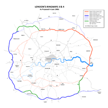
Little was done to progress these plans until the 1960s when the Greater London Council developed its London Ringways plan[15] consisting of four "rings" around the capital. Sections of the two outer rings – Ringway 3 (the 'M16 motorway') and Ringway 4 – were constructed in the early 1970s and were integrated into the single M25 orbital motorway. But the Ringways plan was hugely controversial owing to the destruction required for the inner two ring roads, (Ringway 1 and Ringway 2). Parts of Ringway 1 were constructed (including West Cross Route), against stiff opposition, before the overall plan was abandoned in 1973 following pressure from residents in the threatened areas.
Construction


Construction of parts of the two outer ring roads, Ringways 3 and 4, began in 1973. The first section, between South Mimms and Potters Bar in Hertfordshire (junction 23 to junction 24) opened in September 1975 and was given the temporary general purpose road designation A1178 (a section of motorway-standard-road, originally the M16, which eventually was incorporated into the M25) was completed and operational before this. A Watford-avoiding route between the M1 and the A40 between north Watford and Denham was locally known as the Croxley Green/Rickmansworth bypass, and was operational about 1973/4; a section south of London (junction 6 to junction 8) opened in 1976. A section of Ringway 3 south of the river between Dartford and Swanley (junction 1 to junction 3) was constructed between 1974 and 1977. In 1975 the plans for Ringway 3 were modified to combine it with Ringway 4, the outermost Ringway. The M25 as a component of ringway 4, was first conceived to be an east-west road south of London to relieve the A25, and running parallel to it, with its eastern end following the route of what is now the M26. However, it was subsequently routed northwards towards the Dartford Tunnel to form, in conjunction with similar roads, including the M16 planned to the north of London, part of the London Orbital.[5] The combined motorway was given the designation M25 which had originally been intended for the southern and western part of Ringway 4 and the M16 designation was dropped. The section of Ringway 3 west of South Mimms anti-clockwise around London to Swanley in Kent was cancelled. The stages were not constructed contiguously but in small sections. As the orbital road developed the sections were linked. Each section was presented to planning authorities in its own right and was individually justified, with almost 40 public inquiries relating to sections of the route. Maps at this time depicting these short sections named the route as the M16 but this changed before completion.
The section from Potters Bar to the Dartford Tunnel was constructed between 1979 and 1982. Construction of the M25 continued in stages until its completion in 1986. Prime Minister Margaret Thatcher officially opened the M25 on 29 October 1986, with a ceremony in the section between J22 and J23 (London Colney and South Mimms). The initial tenders for the construction of the M25 totalled £631.9 million. This did not include compulsory purchase of land and subsequent upgrades and repairs.
Operational history

Soon after the motorway opened in 1986 traffic levels exceeded the maximum design capacity and in 1990 the Secretary of State for Transport announced plans to widen the whole of the M25 to four lanes.[16] By 1993 the motorway, which was designed for a maximum of 88,000 vehicles per day, was carrying 200,000 vehicles per day.[17] 15% of UK motorway traffic volume was on the M25 and there were plans to add six lanes to the section from Junctions 12 to 15 as well as widening the rest of the motorway to four lanes.[18]
In parts, particularly the western third this plan went ahead, due to consistent congestion. Again, however, plans to widen further sections to eight lanes (four each way) were scaled back in 2009 in response to rising costs. The plans were reinstated in the agreed Highways Agency 2013-14 business plan.[19]
In 1995 a contract was awarded to widen the section between Junctions 8 and 10 from six to eight lanes for a cost of £93.4 million[20] and a Motorway Incident Detection and Automatic Signalling (MIDAS) system was introduced to the M25 from Junction 10 to Junction 15 at a cost of £13.5m in 1995. This was then extended to Junction 16 at a cost of £11.7m in 2002. This consists of a distributed network of traffic and weather sensors, speed cameras and variable-speed signs that control traffic speeds with little human supervision, and has improved traffic flow slightly, reducing the amount of start-stop driving.[21]

In 1995 there was a proposal to widen the section close to Heathrow Airport to fourteen lanes. This attracted fierce opposition from road protesters opposing the Newbury Bypass and other schemes[22] and it was cancelled shortly afterwards.[23] In 1997, however, the Department of Transport announced new proposals to widen the section between Junction 12 (M3) and Junction 15 (M4) to twelve lanes. At the Terminal Five public inquiry a Highways Agency official said that the widening was needed to accommodate traffic to the proposed new terminal, however the transport minister said that no such evidence had been given.[24] Environmental groups objected to the decision to go ahead with a scheme that would create the widest motorways in the UK without holding a public inquiry.[25] The decision was again deferred. A decision to go-ahead was given for a ten-lane scheme in 1998[26] and the £148 million 'M25 Jct 12 to 15 Widening' contract was awarded to Balfour Beatty in 2003.[27] The scheme was completed in 2005 as dual-five lanes between Junctions 12 and 14 and dual-six lanes from Junctions 14 to 15.[28]
In 2007 capacity at Junction 25 (A10/Waltham Cross) was increased and the Holmesdale Tunnel was widened to three lanes in an easterly direction at a cost of £75 million.[29]
Work to widen the exit slip-roads in both directions at Junction 28 (A12 road/A1023) was completed in 2008. It was designed to reduce the amount of traffic queueing on the slip roads at busy periods, particularly traffic from the clockwise M25 joining the northbound A12 where the queue extended onto the inside lane of the Motorway.[30]
Design, Build, Finance and Operate (DBFO) contract
In 2006 the Highways Agency proposed to widen 63 miles (101 km) of M25 from six to eight lanes, between junctions 5–6 and 16–30 as part of a Design, Build, Finance and Operate (DBFO) project.[31] A shortlist of contractors was announced in October 2006 for the project which was expected to cost £4.5 billion.[32] Contractors were asked to resubmit their bids in January 2008[33] and in June 2009 the new transport minister indicated that the cost had risen to £5.5 billion and the benefit to cost ratio had dropped considerably.[34] In January 2009 the government announced that plans to widen the sections from Junction 5–7 and from 23–27 had been 'scrapped' and that hard shoulder running would be introduced instead. However widening was reinstated to four lanes in the 2013–14 Highways Agency Business Plan.[3][35]
In 2009 a £6.2 billion M25 DBFO private finance initiative contract[36] was awarded to Connect Plus to widen the sections between junctions 16 and 23 and between junctions 27 and 30 and maintain the M25 and the Dartford Crossing for a 30-year period.[37]

Works to widen the section between Junctions 16 (M40) and 23 (A1(M)) to dual four lanes[38] started in July 2009 at an estimated cost of £580 million.[39] The Junction 16 to 21 (M1) section was completed by July 2011 and the Junction 21 to 23 by June 2012.[40] Works to widen the Junctions 27 (M11) to 30 (A13) section to dual four lanes also started in July 2009. The Junction 27 to 28 (A12) section was completed in July 2010,[41] the Junction 28 to 29 (A127) in June 2011 and finally the Junction 29 to 30 (A13) section opened in May 2012.[42]
Works to introduce managed motorway technology and permanent hard shoulder running on two sections of the M25 began in 2013. The first section between Junctions 5 (A21/M26) and 7 (M23) started construction in May 2013 with the scheme being completed and opened in April 2014.[43] The second section, between Junctions 23 (A1/A1(M)) and 27 (M11), began construction in February 2013 and was completed and opened in November 2014.[44]
Developments recently constructed
Junction 30 improvement

In December 2016 Highways England completed the capacity project at Junction 30 (Thurrock) as part of the Thames Gateway Delivery Plan.
The improved junction is said to facilitate billions of pounds of investment in the region, making journeys more reliable and improving safety. In addition, the A13 through the junction has been widened to four lanes in each direction with speed limits capped to 50 mph. New dedicated link roads created and existing slip roads improved to facilitate east bound migration to the Regional Shopping Centre (Lakeside). Drainage, safety barriers and lighting on the M25 have also been upgraded as part of the improvements around Junction 30 and 31 including new electronic gantry signage.
Project Timeline
| August 2014 to December 2014 | Advance scheme work |
| December 2014 | Award of design and build contract |
| Late February 2015 | Start of works on A13 |
| November 2015 | Start of works on M25 |
| December 2016 | Completion of works |
Conditional proposals
Lower Thames Crossing
In 2009 the Department for Transport published options for a new Lower Thames Crossing to add capacity to the Dartford Crossing or create a new road and crossing linking to the M2 and M20 motorways.[45]
Comparisons
The M25 is the second-longest ring road in Europe, after the Berlin Ring (A 10), which is 5 miles (8.0 km) longer.
Other cities in the UK encircled by motorways include: Birmingham, using parts of the M5, M6 and M42, and Manchester, using the M60. Additionally, from 2011 Glasgow has an orbital motorway made of the M8, M73 and M74, although one section of the route passes through the centre of the city.[46]
The M25 is one of the busiest motorways in Europe. Here are some comparisons:
- Saint Petersburg Ring Road: more than 150,000 vehicles on an average day.
- Grande Raccordo Anulare (Rome): more than 160,000 vehicles on an average day
- M25 around London: Average daily traffic of 263,000 vehicles a day recorded in 2014 between junctions 14 and 15 near London Heathrow Airport.[47]
- A23 (Vienna): more than 200,000 vehicles on an average day.
- A 100 (Berlin): 216,000 vehicles in a day was recorded in 1998
- Rotterdam Ring Road: 227,000 vehicles a day, in 8 years 280,000 a day by the Van Brienenoordbrug
- Moscow Ring Road: more than 250,000 vehicles on an average day.
- A4 motorway (Paris): 257,000 vehicles a day recorded in 2002.[48]
Popular culture

Iain Sinclair's 2002 book and film London Orbital is based on a year-long journey around the M25 on foot.[49]
The M25 (including the A282 Dartford Crossing) is known for its frequent traffic jams. These have been the subject of so much comment from such an early stage that even at the official opening ceremony Margaret Thatcher complained about "those who carp and criticise". The jams have inspired jokes (e.g., "the world's first circular car park", "the London Orbital Car Park") and songs (e.g., Chris Rea's "The Road to Hell").[50]
The M25 plays a role in the comedy-fantasy novel Good Omens, as "evidence for the hidden hand of Satan in the affairs of Man".[51] The demon character, Crowley, had manipulated the design of the M25 to resemble a Satanic sigil, and tried to ensure it would anger as many people as possible to drive them off the path of good.[52][53]
The M25 enjoyed a more positive reputation among ravers in the late 1980s, when this new orbital motorway became a popular route to the parties that took place around the outskirts of London. This use of the M25 for these raves inspired the name of electronic duo Orbital.[54]
Racing
The orbital nature of the motorway, in common with racetracks, lent itself to unofficial, and illegal, motor racing. At the end of the 1980s, before the advent of speed enforcement devices, owners of supercars would meet at night at service stations such as South Mimms and conduct time trials. Times below 1 hour were achieved - an average speed of over 117 mph (188 km/h), which included coming to a halt at the Dartford Tunnel road user charge payment booths.[55][56]
Junctions
Data from driver location signs provide carriageway identifier information.[57] The numbers on the signs are kilometres from a point near the River Thames, east of London, when travelling clockwise on the motorway. The table below gives details of each junction, including the roads interchanged and the destinations that are signed from the motorway on the blue advance direction signs. Figures in kilometres are from the driver location signs; figures in miles are derived from them.
| A282 road – Dartford Crossing | |||||
| miles | km[57] | Clockwise exits (A carriageway)[57] | Junction | Anti-clockwise exits (B carriageway) | European Route |
|---|---|---|---|---|---|
| Dartford Crossing South Queen Elizabeth II Bridge (Toll) |
River Thames |
Dartford Crossing North Dartford Tunnels (Toll) |
|||
| 3.5 | 5.7 | Erith A206 | J1A | Erith A206, Swanscombe (A226) | |
| 4.7 | 7.5 | Dartford A225 | J1B | Exit via J2 – Dartford (A225) | |
| M25 motorway – London Orbital | |||||
| 5.5 | 8.8 | London (SE & C), Bexleyheath A2 (W), Canterbury (M2) A2 (E) Ebbsfleet International | J2 | London (SE & C), Bexleyheath A2, Canterbury (M2), Dartford (A225) Ebbsfleet International, Bluewater | |
| 8.7 | 14.0 | London (SE & C) A20 Maidstone, Channel Tunnel, Folkestone M20 Swanley B2173 |
J3 | Maidstone, Channel Tunnel M20 London (SE & C), Lewisham A20 |
|
| 12.2 | 19.6 | Bromley A21 Orpington A224 |
J4 | Bromley, London (SE & C) A21 Orpington (A224) Hayes |
|
| 16.3 16.4 |
26.2 26.4 |
Sevenoaks, Royal Tunbridge Wells, Hastings A21 | J5 | Maidstone, Channel Tunnel, Dover M26 (M20) Sevenoaks, Hastings A21 |
|
| 21.0 | 33.8 | Clacket Lane services | Services | Clacket Lane services | |
| 25.8 | 41.6 | East Grinstead, Eastbourne, Caterham, Godstone A22 Redhill, Westerham (A25) |
J6 | East Grinstead, Eastbourne, Caterham, Godstone A22 Redhill, Westerham (A25) |
|
| 28.6 | 46.0 | Gatwick Airport, Crawley, Brighton, Croydon M23 | J7 | Gatwick Airport, Crawley, Brighton, M23(S), Croydon M23(N) | |
| 31.9 | 51.4 | London (S & SW), Reigate, Sutton A217 Kingston (A240) |
J8 | London (S & SW), Reigate, Sutton A217 Kingston (A240) |
|
| 38.5 39.5 |
62.0 63.5 |
Leatherhead A243, Dorking, (A24) | J9 | Leatherhead A243, Dorking (A24) | |
| 42.6 43.2 |
68.6 69.5 |
Cobham services | Services | Cobham services | |
| 45.0 | 72.4 | London (SW & C), Guildford, Portsmouth A3 | J10 | London (SW & C), Guildford, Kingston A3 | |
| 49.8 | 80.2 | Chertsey A317, Woking A320 | J11 | Woking A320, Chertsey A317 | |
| 52.1 | 83.8 | Basingstoke, Southampton, Richmond M3 | J12 | Basingstoke, Southampton, Richmond M3 | |
| 55.2 | 88.8 | London (W & C), Hounslow, Staines A30 | J13 | London (W & C), Hounslow, Staines A30 | |
| 57.0 | 91.8 | Heathrow Airport (Terminals 4, 5 and Cargo) A3113 | J14 | Heathrow Airport (Terminals 4, 5 and Cargo) A3113 | |
| 59.0 | 95.0 | The West, Slough, Reading, London (W & C), Heathrow Airport (Terminals 1, 2 and 3) M4 |
J15 | The West, Slough, Reading M4(W) London (W & C), Heathrow Airport (Terminals 1, 2 & 3) M4(E) |
|
| 63.8 | 102.6 | The North, Birmingham, Oxford, Uxbridge, London (W & C) M40 | J16 | Birmingham, Oxford M40(W) Uxbridge, London (W & C) M40(E) |
|
| 68.7 | 110.5 | Rickmansworth, Maple Cross (A412) | J17 | Rickmansworth, Maple Cross A412 | |
| 69.9 | 112.5 | Chorleywood, Amersham A404 | J18 | Chorleywood, Amersham A404 | |
| 71.5 | 116.4 | Watford A41 | J19 | Exit via J20 – Watford A41 | |
| 73.5 | 118.2 | Hemel Hempstead, Aylesbury A41 | J20 | Hemel Hempstead, Aylesbury, Watford A41 | |
| 76.3 | 122.8 | The North, Luton & Luton Airport M1 | J21 | The North, Luton & Luton Airport M1 | |
| 76.9 | 123.7 | Watford A405 Harrow (M1 South) |
J21A | St Albans A405 London (NW & C) (M1 (South)) |
|
| 80.6 | 129.7 | London Colney A1081 | J22 | St Albans A1081 | |
| 83.3 | 134.0 | Hatfield A1(M), London (NW & C) A1, Barnet A1081 South Mimms services |
J23 | Hatfield A1(M), London (NW & C) A1, Barnet A1081 South Mimms services |
|
| 85.9 | 138.2 | Potters Bar A111 | J24 | Potters Bar A111 | |
| 91.4 | 147.1 | Enfield Town, Hertford A10 | J25 | Enfield, Hertford, London (N & C) A10 | |
| 94.9 | 152.7 | Waltham Abbey, Loughton A121 | J26 | Waltham Abbey, Loughton A121 | |
| 99.2 | 159.7 | London (NE & C), Stansted Airport, Harlow, Cambridge M11 | J27 | London (NE & C) M11(N), Stansted Airport, Harlow, Cambridge M11(S) | |
| 107.1 | 172.4 | Chelmsford, Witham, Colchester A12 Brentwood A1023 |
J28 | Chelmsford, Romford A12 Brentwood A1023 |
|
| 109.9 | 176.8 | Romford, Basildon, Southend A127 | J29 | Basildon, Southend, Romford A127 | |
| 115.2 | 185.4 | Tilbury, Thurrock, Lakeside A13(E), London (E & C) A13(W) Thurrock services |
J30 | London (E & C), Barking, Tilbury, Basildon, Dagenham, Rainham A13 | |
| A282 Road – Dartford Crossing | |||||
| 115.9 | 186.6 | Exit via J30 – Purfleet (A1090), South Ockendon, Thurrock services A1306 | J31 | Thurrock (Lakeside), Thurrock services A1306, Purfleet (A1090), West Thurrock (A126) | |
| Dartford Crossing South Queen Elizabeth II Bridge (Toll) |
River Thames |
Dartford Crossing North Dartford Tunnels (Toll) |
|||
Notes
| |||||
1.000 mi = 1.609 km; 1.000 km = 0.621 mi
| |||||
References
Citations
- 1 2 "Motorway traffic up 4% on 2003". BBC News. 12 August 2004. Retrieved 3 January 2009.
- ↑ Office for National Statistics Social Trends - Transport p197
- 1 2 Business Plan 2013-14 Highways Agency
- ↑ "New Lower Thames Crossing to cut congestion and create thousands of jobs". www.gov.uk.
- 1 2 "M25 in South East Region". The Motorway Archive. 2009. (Select "M25" from list of motorways, then "M25 interchanges, tunnels and bridges"). Retrieved 18 April 2013.
- ↑ Grid reference Finder Generic map measurement tools
- ↑ This move would be bound to be resisted by the communities affected, including such major towns as Watford, Loughton and Epsom. The M25 is called “The Worst Road To Go To” according to many Londoners and Visitors. London Assembly Archived 9 October 2008 at the Wayback Machine. – Poll says M25 is London's "natural boundary". 2 March 2004.
- ↑ Communications Act 2003, The National Archive, 2003, retrieved 5 September 2011 that requires "a suitable proportion of the programmes made in the United Kingdom" to be made "in the United Kingdom outside the M25 area", defined in Section 362 as "the area the outer boundary of which is represented by the London Orbital Motorway (M25)".
- ↑ "M25 MSA New Barn Farm Cobham". Highways Agency. Archived from the original on 3 March 2010. Retrieved 14 August 2010.
- ↑ "Cobham M25 service station opened". BBC News. 13 September 2012. Retrieved 13 September 2012.
- ↑ J. F. Bramley (1946). Roads for Britain: a digest of plans of future highways (2nd ed.). Staples Press. p. 14.
- ↑ Smith 2001, p. 148.
- ↑ John Henry Forshaw, Sir Patrick Abercrombie (1943). "County of London plan". London County Council: 13.
- ↑ Hamilton 2015, p. 19.
- ↑ London Ringways Plan "Archived copy". Archived from the original on 18 November 2012. Retrieved 24 November 2012. Retrieved 6 January 2013
- ↑ "Hansard 3 December 1990 Written Answers (Commons) Transport".
- ↑ "The bluffer's briefing on: The M25". The Independent. London. 24 March 1993. Retrieved 12 May 2010.
- ↑ "M25 (Widening)". Hansard.
- ↑ Webster, Ben (25 June 2009). "Rising costs put the brakes on dozens of roadbuilding projects". The Times. London. Retrieved 12 May 2010.
- ↑ "M25 scoop for Balfour in Surrey".
- ↑ "Case Study – M25 Controlled Motorway". Highways Agency. Archived from the original on 11 February 2010.
- ↑ Wolmar, Christian (4 April 1995). "The roadblock that became a bandwagon". The Independent. London. Retrieved 12 May 2010.
- ↑ Cohen, Nick (2 April 1995). "Pointless lies that reveal so much". The Independent. London. Retrieved 12 May 2010.
- ↑ Wolmar, Christian (21 March 1997). "Minister gives green light to widen M25". The Independent. London. Retrieved 12 May 2010.
- ↑ "Plans to widen M25 to 12 lanes under attack". Archived from the original on 5 April 2012.
- ↑ "BAA makes plans for Terminal 5 despite inquiry".
- ↑ "M25 Junctions 12 – 15 Widening". Archived from the original on 5 September 2011.
In 2003, Balfour Beatty Civil Engineering was awarded the £148 million contract to widen the 10-mile stretch of the M25, between Junction 12 (the M3 Interchange) and Junction 15 (the M4 Interchange).
- ↑ "M25 Jct 12 to 15 Widening". Highways Agency. Archived from the original on 26 September 2008.
- ↑ "£75 MILLION REFURBISHMENT FOR M25 HOLMESDALE TUNNEL AND JUNCTION 25 IMPROVEMENT WORK STARTS ON SATURDAY 6 May". Highways Agency. Archived from the original on 6 November 2008.
- ↑ "M25 Junction 28 / A12 / Brook Street Interchange". Highways Agency. Archived from the original on 26 September 2008.
- ↑ "Prequalification Document". Highways Agency. Archived from the original on 7 November 2008. Retrieved 20 January 2008.
- ↑ "Highways Agency announces shortlist for £4.5bn M25 DBFO". Contract Journal. Archived from the original on 16 January 2016. Retrieved 20 January 2008.
- ↑ Andrea Klettner (16 January 2008). "Highways Agency calls for M25 widening bids to be resubmitted". Construction Journal. Retrieved 20 January 2008.
- ↑ "Cost escalation hits M25 widening benefit to cost ratios".
- ↑ Helm, Toby (18 January 2009). "Ministers scrap plan to widen motorways". The Guardian. London. Retrieved 12 May 2010.
- ↑ Webster, Ben (20 May 2009). "PFI deal for M25 agreed despite price rise". The Times. London. Retrieved 12 May 2010.
- ↑ "£6.2 billion M25 Design, Build, Finance and Operate (DBFO) contract awarded". Highways Agency. Archived from the original on 15 November 2009.
- ↑ "M25 Jct 16 to 23 Widening". Archived from the original on 22 September 2009.
- ↑ "M25 widening to four lanes begins". BBC News. 8 July 2009. Retrieved 12 May 2010.
- ↑ "Highways Agency Timetable". Archived from the original on 26 September 2008.
- ↑ "Weekly Summary of Roadworks in M25 Sphere – 30 September 2009".
- ↑ "M25 Jct 27 to 30 Widening". Archived from the original on 4 October 2009.
- ↑ "M25 Junctions 5 to 7 Managed Motorways".
- ↑ "M25 Junctions 23 to 27 Managed Motorways".
- ↑ "Dartford River Crossing Study into Capacity Requirement" (PDF). Department for Transport. 20 April 2009. Archived from the original (PDF) on 19 July 2009. Retrieved 26 April 2009.
- ↑ "Transport Scotland – M74 Completion Project". Archived from the original on 18 December 2009. Retrieved 6 September 2009.
- ↑
- ↑ "Compte Rendu Analytique Officiel de la Seance du 17 Decembre 2002" (in French).
- ↑ Lezard, Nicholas (21 September 2002). "Meandering round the M25". The Guardian.
- ↑ "Chris Rea interviewed by Will Hodgkinson, The Guardian, Friday 13 September 2002". London. 13 September 2002. Retrieved 31 January 2009.
- ↑ "Good Omens Annotations".
- ↑ Pratchett, Terry; Gaiman, Neil (1993). Good Omens. London: Corgi Books. p. 19. ISBN 0552137030.
- ↑ Neil Gaiman (11 April 2003). "Neil Gaiman's Journal". HarperCollins. News Corp. Retrieved 25 March 2017.
- ↑ "Orbital information". Archived from the original on 15 February 2011. Retrieved 28 January 2011.
- ↑ May, James (20 October 2007). "Speed, Greed And The M25". BBC Radio 4.
- ↑ "Programme Information – Network Radio Week 43" (Press release). BBC Press Office.
- 1 2 3 "M25 Road Network Driver Location Signs" (PDF). Highways Agency. Archived from the original (PDF) on 5 June 2011. Retrieved 9 June 2009.
Sources
Further reading
- Sinclair, Iain (2002), London Orbital: A Walk Around the M25, London: Granta Books, ISBN 1-86207-547-6 .
- Phippen, Roy (2005), Travelling M25 Clockwise, London: Pallas Athene, ISBN 1-873429-90-8 .
External links
| Wikimedia Commons has media related to M25 motorway. |
Route map:
- Highways Agency – Roadworks
- Highways Agency – Current Traffic Information
- Highways Agency – Dartford – Thurrock River Crossing
- The Motorway Archive's M25 page
- CBRD M25 Motorway Database
- CBRD M25 Opening Booklet
- Opening dates 1975-1986
| Great Britain | .svg.png) | |||||
|---|---|---|---|---|---|---|
| Northern Ireland | ||||||
| Former | ||||||
| Unbuilt | ||||||
| Proposed | ||||||
| Junctions | ||||||
| Related articles | ||||||
| ||||||
| Road |
| ||||||||||||||
|---|---|---|---|---|---|---|---|---|---|---|---|---|---|---|---|
| Rail |
| ||||||||||||||
| Air | |||||||||||||||
| Waterways |
| ||||||||||||||
| Footpaths |
| ||||||||||||||
| Cycle paths | |||||||||||||||
| Related articles |
| ||||||||||||||