Thames Path
| Thames Path | |
|---|---|
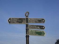 The Thames Path sign at the end of the walk, by the Thames Barrier | |
| Length | 184 mi (296 km) |
| Location | Southern England, United Kingdom |
| Designation | UK National Trail |
| Trailheads | Kemble, Gloucestershire and Thames Barrier, Charlton, London |
| Use | Hiking, cycling |
| Hiking details | |
| Season | All year |
The Thames Path is a National Trail following the River Thames from its source near Kemble in Gloucestershire to the Thames Barrier at Charlton, south east London. It is about 184 miles (296 km) long.[1] A path was first proposed in 1948 but it only opened in 1996.[2]
The Thames Path's entire length can be walked, and a few parts can be cycled. Some parts of the Thames Path, particularly west of Oxford, are subject to flooding during the winter. The river is also tidal downstream from Teddington Lock and parts of the path may be under water if there is a particularly high tide. Most of the Thames Path uses the river towpath. Historically, towpath traffic crossed the river using many ferries, [3] but crossings in these places do not all exist now and some diversion from the towpath is necessary.
The Thames towpath [4] was generally extended upstream on the non-tidal river to Inglesham by the Thames Navigation Commission due to the opening of the now disused Thames and Severn Canal in 1789, one and a half miles upstream of the highest boat lock near Lechlade.[5] This point is the limit of navigation for powered craft and although there is a right of navigation for smaller craft up to Cricklade, there is no further towpath so if no other riverside right of way exists, the Thames path diverts away from the river to extend the route to Thames Head. A section of permissive path now exists alongside the river at Upper Inglesham.
Today, between Inglesham and Putney Bridge, the towpath still allows access by foot to at least one side of the river for the whole length of the main navigation of the river (but not mill streams, backwaters or a few meanders cut off by lock cuttings) since towpaths were only dedicated to enable horse drawing of barge traffic. The main exception to this is a stretch of river without any dedicated path in Home Park, Windsor lost as a consequence of the removal of Datchet Bridge as part of changes due to the Windsor Castle Act 1848, and which accounts for the Thames Path's diversion from the river at Datchet. There are also two other short sections of river missing towpath: between Marlow bridge and lock, and either side of The Swan public house in Pangbourne. Otherwise, between Inglesham and Putney, the Thames Path only make diversions from the remaining towpath due to the lack of a lock, bridge or ferry to cross the river in the original locations. There are also some lengths of river bypassed by navigation cuttings which are still accessible directly off the Thames Path at Sutton Pools, Penton Hook Lock and Desborough Island.
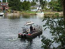
Historically, there have been replacements for towpath ferry crossings with bridges at Goring, Clifton Hampden and Bourne End and the path across the weir at Benson Lock (ferry was upstream [6]). In recent times, crossings have been created for the Thames Path; the Shepperton to Weybridge Ferry was restarted in 1986, Temple Footbridge near Hurley was built in 1989, a footpath attached to Bourne End Railway Bridge in 1992 (ferry was upstream [7]), and Bloomers Hole Footbridge was built in 2000. No other replacement river crossings have been created for lapsed ferries, so the Thames Path has to divert away from the towpath to cross the river elsewhere, leaving some sections of towpath unused. Walkers can still divert to explore those parts of the river not on the path, with the exception of two places, where there are now isolated sections of towpath not connected by any public path, or ferry at either end. The first is 1km downstream of Mapledurham Lock, which accounts for the path's diversion from the river at Purley-on-Thames. The second and most downstream is a section of towpath requiring National Trust entry to Cliveden, which accounts for the path's diversion from the river at Cookham. Also, when Cookham Lock was built in 1830, Hedsor Water became a backwater and lost its towpath.
The Locks on the River Thames are pleasant places to visit on the Thames path, and all but two are on or very close to the Thames Path; and of these, only Marlow Lock does not have immediately obvious access from the Thames Path. Cookham Lock cutting was built through and around two islands in the river; and Cookham Lock is still accessible but is not on the Thames Path as the Thames divides into several streams here and the towpath does not connect up without ferries, so access to it from the path requires a near 1km walk across Odney Common on Formosa Island and Mill Eyot to Sashes Island. Finally, Whitchurch Lock cutting was built through an island in the river and public access to the lock over the weir from Pangbourne or across the millstream at Whitchurch-on-Thames has been lost; as a consequence Whitchurch Lock is the only Thames lock that is inaccessible by foot - it is only accessible by boat [8]. Locks had made the whole river navigable from Inglesham to the upper limit of the tidal reach at Staines by 1789. On the tidal Thames below Staines, six locks were built by the City of London Corporation to improve the navigation between 1811 and 1815.
Today, the river is tidal downstream from Teddington Lock, although it only sees low tide below Richmond Lock, as the adjacent footbridge incorporates a low-tide barrage built in 1894 to maintain the river upstream to at least half tide level. Downstream of Teddington Lock, there is a path on both sides of the river. Downstream of Putney, sections of the Thames Path(s) often divert away from the river around riverside buildings.[9] Historical records state that the towpath started at Putney [10], so the Port of London never had an intentional continuous towpath, since sailing, rowing, and following the rising and falling tide were the means of navigation; and crossing the river was the priority as evidenced by the many Watermen's stairs giving watermen and passengers access to the tidal river. Chiswick Eyot is notable as being the only tidal island on the river.
In central London, the path is one of the Mayor of London's Strategic walking routes. The Thames Path Cycle Route is a black-signposted route that follows the river between Putney Bridge in the west and Greenwich in the east. It mostly follows the Thames Path, but diverges in various sections, especially where the path follows a footpath-only route. It also links National Cycle Route 1 (east of London) with National Cycle Route 4 (west of London).[11]
Route
The route can be divided into these sections:
- Thames Head (source of the river west of Cricklade) to Oxford (54 mi or 87 km): a generally rural, agricultural area. The path makes significant diversions away from the river (in order going downstream) at Ewen, Ashton Keynes, Cricklade, Castle Eaton and Upper Inglesham due to the lack of a public path alongside the river until reaching the towpath at Lechlade (23 mi or 37 km); after Lechlade there is only one significant diversion from the river at Stanton Harcourt as there is now no ferry at Bablock Hythe [12].
- Oxford to Henley-on-Thames (51 mi or 82 km): passing through Abingdon, Dorchester, Wallingford, Streatley and Reading. The path makes significant diversions away from the river (in order going downstream) at Shillingford [13], Moulsford [14][15], Whitchurch-on-Thames [16], Purley-on-Thames [17], Shiplake [18][19] and Aston [20][21] due to the lack of ferries allowing the towpath to cross the river. In addition a short section in Wallingford goes behind houses, as the towpath used to cross at Chalmore Lock,[22] now removed.
- Henley to Windsor: (23 mi or 37 km): through Marlow and Maidenhead. The path makes a significant diversion away from the river past Cookham Lock due to the lack of ferries [23] and public access to the towpath at Cliveden. In addition there is a short stretch with no public path in Marlow town centre, and a short section in Bourne End goes behind boathouses as the river crossing is not aligned with the original towpath.
- Windsor to Richmond (28 mi or 45 km): along the edge of Windsor Great Park; past Runnymede; through Hampton Court Park. The path does not leave the river apart from the short stretch where no public path exists at Datchet. It is also necessary to take a diversion if not using the Shepperton to Weybridge Ferry. The river level is tidal and maintained at or above half tide between Teddington and Richmond locks.
- Richmond to the Thames Barrier (28 mi or 45 km): passing Kew Gardens and the Wetlands Centre at Barnes then through London, using parkland (e.g., Battersea Park) to continue beside the river. Through most of the section, the Thames Path is actually two paths downstream of Teddington lock, one on either side of the Tideway. The path often diverts away from the river around riverside buildings.
- Thames Barrier to Crayford Ness, just beyond Erith (10 mi or 16 km), connecting with the London Outer Orbital Path. This is considered an extension of the Thames Path (as recognised by the Ramblers Association) and was opened in 2001, but is not part of the National Trail. It has its own Thames Barge symbol, and is sometimes referred to as the Thames Path Southeast Extension. The path often diverts away from the river around riverside buildings.
Thames crossings
The list below shows the points going downstream where the path crosses the river between Cricklade and Teddington. Above Cricklade the Thames is a stream and in some places there may be no water except after rain. Below Teddington there are paths on both sides of the river until the Greenwich foot tunnel, after which the path is only on the south. The letter in brackets indicates whether the path downstream of that point is on the northern or southern bank (using north or south in reference to the river as a whole, rather than at that specific point). Bridges and ferries are listed in full under Crossings of the River Thames. Islands are listed under Islands in the River Thames.
- Cricklade (S)
- Eysey Footbridge (N)
- Water Eaton House Bridge (S)
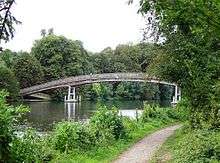
- Bloomers Hole Footbridge (N)
- Radcot Bridge (S)
- Tadpole Bridge (N)
- Tenfoot Bridge (S)
- Newbridge, Oxfordshire (N)
- Pinkhill Lock (S)
- Fiddler's Island (N)
- Osney Bridge (S)
- Abingdon Lock (N)
- Clifton Hampden Bridge (S)
- Day's Lock (N)
- Benson Lock (S)
- Goring and Streatley Bridge (N)
- Whitchurch Bridge (S)
- Sonning Bridge (N)
- Henley Bridge (S)
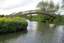
- Temple Footbridge (N)
- Bourne End Railway Bridge (S)
- Maidenhead Bridge (N)
- Windsor Bridge (S)
- Victoria Bridge, Datchet (N)
- Albert Bridge, Datchet (S)
- Staines Bridge (N)
- Shepperton to Weybridge Ferry (S)
- Hampton Court Bridge (N)
- Kingston Bridge, London (S)
- Teddington Lock Footbridges
The reverse direction of the path going upstream on the non-tidal part is obtainable by following the locks up from Teddington Lock. Between Teddington Lock and Lechlade the locks divide the river into reaches and a description of the reach above each lock includes the route of the Thames Path going upstream. Locks are listed under Locks on the River Thames.
References
- ↑ "Thames Path". nationaltrail.co.uk. Retrieved 18 May 2016.
- ↑ "Thames Path". ramblers.org.uk. Retrieved 31 July 2018.
- ↑ Fred. S. Thacker The Thames Highway: Volume II Locks and Weirs 1920 – republished 1968 David & Charles http://thames.me.uk/thacker1920.htm
- ↑ http://www.the-river-thames.co.uk/manage.htm The River Thames — Its management past and present
- ↑ http://thames.me.uk/ThamesHall.htm
- ↑ Benson ferry http://thames.me.uk/s01341.htm
- ↑ Spade Oak ferry http://thames.me.uk/s00790.htm
- ↑ https://whitchurchonthames.com/lock.html
- ↑ https://www.theguardian.com/cities/2015/feb/24/private-london-exposed-thames-path-riverside-walking-route
- ↑ http://thames.me.uk/Thamestour1829.htm
- ↑ http://www.bexley.gov.uk/index.aspx?articleid=3185
- ↑ Bablock Hythe ferry http://thames.me.uk/s01970.htm
- ↑ ferry upstream of Shillingford http://thames.me.uk/s01352.htm
- ↑ Littlestoke ferry http://thames.me.uk/s01310.htm
- ↑ Moulsford ferry http://thames.me.uk/s01290.htm
- ↑ Gatehampton ferry http://thames.me.uk/s01235.htm
- ↑ Purley Hall ferries http://thames.me.uk/s01180.htm
- ↑ Lashbrook ferry http://thames.me.uk/s01052.htm
- ↑ Bolney ferry http://thames.me.uk/s01050.htm
- ↑ Medmenham ferry http://thames.me.uk/s00862.htm
- ↑ Aston ferry http://thames.me.uk/s00860.htm
- ↑ Chalmore Lock http://thames.me.uk/s01320.htm
- ↑ Cliveden ferries http://thames.me.uk/s000748.htm
| Road |
| ||||||||||||||
|---|---|---|---|---|---|---|---|---|---|---|---|---|---|---|---|
| Rail |
| ||||||||||||||
| Air | |||||||||||||||
| Waterways |
| ||||||||||||||
| Footpaths |
| ||||||||||||||
| Cycle paths | |||||||||||||||
| Related articles |
| ||||||||||||||