Dagenham
| Dagenham | |
|---|---|
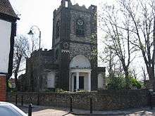
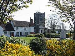 The church of St Peter and St Paul formed the heart of the former village | |
 Dagenham Dagenham shown within Greater London | |
| Population | 11,267 (2011 Census. Goresbrook Ward)[1] |
| OS grid reference | TQ485845 |
| • Charing Cross | 11.5 mi (18.5 km) W |
| London borough | |
| Ceremonial county | Greater London |
| Region | |
| Country | England |
| Sovereign state | United Kingdom |
| Post town | DAGENHAM |
| Postcode district | RM8, RM9, RM10 |
| Dialling code | 020 |
| Police | Metropolitan |
| Fire | London |
| Ambulance | London |
| EU Parliament | London |
| UK Parliament | |
| London Assembly | |
Dagenham (/ˈdæɡənəm/) is a town in East London, England.[2] In the London Borough of Barking and Dagenham, it is 11.5 miles (18.5 km) east of Charing Cross and 9.5 miles (15.2 km) east of the City of London. Historically a parish in the county of Essex, it was an agrarian village and remained mostly undeveloped until 1921, when the London County Council began construction of the large Becontree estate. The population of the area significantly increased in the 20th century, with the parish of Dagenham becoming an urban district in 1926 and a municipal borough in 1938. It has formed part of Greater London since 1965 and is a predominantly residential area, with some areas of declining industrial activity, including the Ford Dagenham plant. The southern part of Dagenham, adjacent to the River Thames, forms part of the London Riverside section of the Thames Gateway redevelopment area.
History
| 1888 | 3 |
|---|---|
| 1890 | 4 |
| 1969 | 6,091 |
| 1911 | 1 |
| 1921 | 9,127 |
| 1931 | 89,362 |
| 1941 | # |
| 1951 | 114,568 |
| 1961 | 108,368 |
| # no census was held due to war | |
| source: UK census | |
Toponomy
Dagenham first appeared in a document (as Dæccanhaam) in a charter of Barking Abbey dating from 666 AD. The name almost certainly originated with a small farmstead, the "ham" or farm of a man called Daecca, as Dæccan hamm in Old English means home of a man called Dæcca.[3]
Economic development
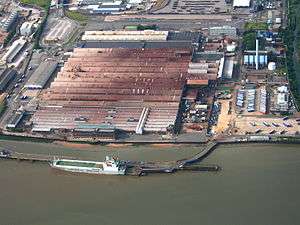
In 1931 the Ford Motor Company relocated from Trafford Park in Manchester, to a plant in Dagenham, which was already the location of supplier Briggs Motorway Bodies. A 500-acre (2 km²) riverside site was developed to become Europe's largest car plant, a vast vertically integrated site with its own blast furnaces and power station, importing iron ore and exporting finished vehicles. By the 1950s Ford had taken over Briggs at Dagenham and its other sites at Doncaster, Southampton, Croydon and Romford. At its peak the Dagenham plant had 4,000,000 square feet (370,000 m2) of floor space and employed over 40,000 people, although this number gradually fell during the final three decades of the 20th century as production methods advanced and Ford invested in other European factories as well.[4]
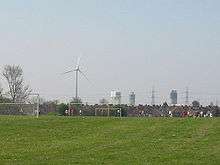
On 20 February 2002, full production was discontinued due to overcapacity in Europe and the relative difficulty of upgrading the 60-year-old site compared with other European sites such as Almussafes (Valencia, Spain) and Cologne. Other factors leading to the closure of the Auto-assembly line were the need of the site for the new Diesel Centre of Excellence, which produces half of Ford's Diesel Engines worldwide, and the UK employment laws when compared to Spanish, German and Belgian laws. In 2005 Cummins went into a joint venture and offered $15 million (US) to reinstate the factory. Ford and Cummins offered a good redundancy package, billed as one of the best in UK manufacturing. It is the location of the Dagenham wind turbines.[5] Some 4,000 people now work at the Ford plant.[6] The movie Made in Dagenham (2010) is a dramatisation of the 1968 Ford sewing machinists strike at the plant, when female workers walked out in protest against sexual discrimination and unequal pay.
Sterling who were famous for manufacturing British Army weapons and Jaguar car parts were also based in Dagenham until they went bankrupt in 1988. Other industrial names once known worldwide were Ever Ready, whose batteries could be found in shops throughout the Commonwealth, Bergers Paint and the chemical firm of May & Baker who in 1935 revolutionized the production of antibiotics with their synthetic sulfa-drug known as M&B 693. The May & Baker plant, owned and run by Sanofi-Aventis, occupied a 108-acre site in Rainham Road South, near Dagenham East Underground station. It was abandoned in 2013 when the company closed it. The council has decided how to use the vacant site. They will redevelop it with a new shopping centre: stores announced so far are a Sainsbury's supermarket and a pub restaurant. More stores will be announced in the future.
Local government
Dagenham was an ancient, and later civil, parish in the Becontree hundred of Essex.[7] The Metropolitan Police District was extended in 1840 to include Dagenham. The parish formed part of the Romford Rural District from 1894.[8][9] Dagenham Parish Council offices were located on Bull Street.
The expansion of the Greater London conurbation into the area caused the review of local government structures, and it was suggested in 1920 that the Dagenham parish should be abolished and its area divided between Ilford Urban District and Barking Town Urban District.[10] Separately, the London County Council proposed that its area of responsibility should be expanded beyond the County of London to cover the area.[11] Instead, in 1926 the Dagenham parish was removed from the Romford Rural District and designated as an urban district.[8] In 1938, in further recognition of its development, Dagenham became a municipal borough.[12] In 1965 the Municipal Borough of Dagenham was abolished and its former area became part of the London Borough of Barking,[13] which was renamed Barking and Dagenham in 1980.[14]
Market gardens to suburban estate
In 1205 Dagenham was large enough to have a chaplain, and the Parish Church of St Peter and St Paul was probably built at around that time.[15] In 1854, the London, Tilbury and Southend Railway was built through the south of Dagenham, near the River Thames. In 1885 a new direct route from Barking to Pitsea, via Upminster, was built with Dagenham station opened just north of the village. Dagenham Dock station opened on the original southern route in 1908. Dagenham was still an undeveloped village, when building of the vast Becontree estate by the London County Council began in the early 1920s.[16] The building of the enormous council estate, which also spread into the neighbouring parishes of Ilford and Barking,[10] caused a rapid increase in population.[17] In 1932 the electrified District line of the London Underground was extended to Upminster through Dagenham with stations opened as Dagenham and Heathway and today called Dagenham East and Dagenham Heathway.[18] Dagenham East was the location of the Dagenham East rail crash in 1958.[19] Services on the London Tilbury & Southend line at Dagenham East were withdrawn in 1962.
Governance
The wards of Eastbrook, Heath, River, Village and Whalebone are in the Dagenham and Rainham Parliamentary Constituency. The wards of Alibon, Mayesbrook, Parsloes, Thames and Valence are in the Barking Parliamentary Constituency. Each ward elects three councillors to Barking and Dagenham London Borough Council. The whole area is within the City and East London Assembly Constituency.
Geography
Dagenham is located approximately 11.5 miles (18.5 km) east of Charing Cross in Central London. A large part of Dagenham is within the Becontree estate; however, the area also includes Becontree Heath, part of Rush Green, Old Dagenham village, and the southern section around Dagenham Dock and adjacent to the River Thames. This southern section, which includes Ford Dagenham, is part of the London Riverside section of the Thames Gateway redevelopment zone. The Dagenham post town includes the whole of the Becontree estate, including those sections that were constructed in Barking and Ilford.
Demography
Dagenham is a working class area. During the 2000s there has also been a large influx of migrants, in particular Africans.[20] It is difficult to approximate the population of Dagenham alone since it was merged with Barking as part of the formation of Greater London in 1965. In addition there are numerous different wards that cover the Dagenham district.
At the time of the 2011 census, the Alibon ward (north of Heathway station) was 61% White British and 15% Black African.[21] Goresbrook ward (southwest from Heathway) was 57% White British and 17% Black African.[22] River ward (south of Heathway) was 51% White British and 19% Black African.[23] Village ward (east from Heathway) was 58% White British and 19% Black African.[24] Eastbrook ward (around Eastbrookend Country) was 69% White British and 11% Black African.[25] Heath ward (north of Heathway) was 60% White British and 17% Black African.[26]
Dagenham is more ethnically homogeneous compared to the other town of the borough, Barking, where the indigenous population is in the minority.
Transport
There are London New the services from Becontree, Dagenham East and Dagenham Heathway, all on the District line. c2c, currently operated by Trenitalia, part of National Rail, run a service from Dagenham Dock.[27] TfL Rail services also operate from nearby Chadwell Heath.
Dagenham Heathway is served by the following Transport for London contracted routes: London Buses routes 145,173,174,175,287]] and 364.[28] Routes 5, 103, 128, 150, 173, 174, 175, 499, and N15 and East London Transit service EL2 operate from Becontree Heath or the nearby Dagenham Civic Centre. Route 128 and EL1 runs a 24-hour service, while the N15 runs through the night.[29]
Culture
Valence House is in Becontree Avenue. It is the only surviving of the five manor houses of Dagenham.[30] Dating back to the 13th century it is sited in parkland and is partially surrounded by a moat. Valence House is the borough's local history museum, displaying an impressive collection of artifacts and archives that tell the story of the lives of the people of Barking and Dagenham. The collection also includes portraits, family papers and other mementoes of the Fanshawe family, who occupied Parsloes Manor, since demolished, from the sixteenth century.[31] The Fanshawe collection is "one of the best collections of gentry portraits in the country and is of international importance," according to Valence House.[32] Among members of the Fanshawe family was the diplomat Sir Richard Fanshawe, 1st Baronet, whose portrait is at Valence House. Nine successive members of the Fanshawe family served as Remembrancer to the Crown, following Henry Fanshawe's appointment to the position by Queen Elizabeth I in 1566. The appointment made possible the family's rise to prominence.
On the corner of Whalebone Lane and the Eastern Avenue, diagonally opposite the Moby-Dick public house, is the site of Marks Manor House, a large 15th century moated building demolished in the early 19th century. During World War II the adjoining fields were used by the Royal Artillery for an anti-aircraft battery; later a prisoner-of-war camp for Germans was erected there. Further south down Whalebone Lane on the corner of the High Road is the Tollgate pub. This stands on the site of the milestone which marked the ten mile (16 km) limit from the City of London and the turnpike toll-gate.
The Roundhouse public house on the junction of Porters Avenue and Lodge Avenue became East London's premier rock-music venue between 1969 and 1975, incorporating the Village Blues Club. Notable performers at the pub included Jethro Tull, Supertramp, Queen, Pink Floyd, Eric Clapton, Status Quo, and Led Zeppelin (on 5 April 1969). The Eastbrook is a Grade II* listed pub.[33]
Sport
Dagenham & Redbridge F.C., based in Dagenham, are currently playing in the National League having been relegated in the 2015/16 season from the Football League Two, after being relegated from the Football League One in the 2010/11 season which they had reached having been promoted as playoff-winners of League two after beating Rotherham United F.C. 3–2. Prior to this, they were the Nationwide Conference champions in the 2006/7 season. They play at the London Borough of Barking & Dagenham Stadium, on Victoria Road.
Motorcycle speedway was staged at the greyhound stadium in Ripple Road in the mid to late 1930s. The club run events focussed on training but a team called the Dagenham Daggers did take part in local competitions. It is possible that the venture was operational as early as 1931 a meeting at Caxton (Cambridgeshire) was advertised as Caxton Speedway v Dagenham Speedway.
Dagenham's leading cricket club Goresbrook Cricket Club are based at the May & Baker Sports Club in Rainham Road South, in 2011 the club won the Essex County Cricket League for the first time in its history.
Dagenham has a King George's Field in memorial to King George V. The park, which has been in existence for over a century, was renamed in 1953 by Queen Elizabeth II. Dagenham also has many other parks such as Valence and Parsloes. Dagenham Crusaders Drum and Bugle Corps, founded by John Johnson, were the first British Drum Corps and performed in America for the first time in 1983. They have recently reformed to perform for DCUK's 30th anniversary, and in 2010 are fielding a competitive corps for the first time in 22 years.
The town is also home to the Dagenham Girl Pipers, a bagpipe marching band founded in 1930 by the Rev Joseph Waddington Graves.
Notable people
- Rev. Abraham Blackborne, one of the longest-serving vicars of Dagenham.[34]
- England international footballer and World Cup-winning manager Alf Ramsey was born in Dagenham in 1920.[35]
- St Peter and Paul's Church in Dagenham was once the Parish Church of the former Archbishop of Canterbury, George Carey.
- Musician and comedian Dudley Moore was brought up in Dagenham,[36] which was the home of Peter Cook and Dudley Moore's famous comic alter-egos Pete and Dud.[37]
- Sandie Shaw, 1960s pop singer, who had a string of hit singles in the decade and won the Eurovision Song Contest in 1967 with Puppet on a String
- Rap artist Devlin is from Dagenham.
- Actor, comedian, screenwriter, producer and author Nick Frost is from Dagenham.
- Depeche Mode member Martin Gore was born in Dagenham.
- Cage Warriors matchmaker Ian Dean is from Dagenham.
- Australian singer John Farnham was born in Dagenham before migrating.[38]
- Former darts player Wayne Mardle was born in Dagenham before living in Romford.
References
- Notes
- ↑ "Barking and Dagenham Ward population 2011". Neighbourhood Statistics. Office for National Statistics. Retrieved 17 October 2016.
- ↑ Mayor of London. "North East London sub-region". Greater London Authority. Retrieved 12 August 2012.
- ↑ Mills 2001, p. 64
- ↑ Ford UK – History of Ford in Britain Archived 17 December 2007 at the Wayback Machine.
- ↑ Greater London Authority – Wind Turbines, Ford Estate, Dagenham planning application Archived 4 June 2011 at the Wayback Machine.. 4 June 2003.
- ↑ le80-years-of-manufacturing/ Milestones: Ford Dagenham Estate Celebrates 80 Years of Manufacturing. TheDetroitBureau.com (13 May 2009). Retrieved on 2012-08-08.
- ↑ British History Online – The Hundred of Becontree
- 1 2 Vision of Britain – Dagenham parish Archived 1 October 2007 at the Wayback Machine. (historic map Archived 30 September 2007 at the Wayback Machine.)
- ↑ Vision of Britain – Romford RD Archived 30 September 2007 at the Wayback Machine. (historic map Archived 30 September 2007 at the Wayback Machine.)
- 1 2 British History Online – The borough of Barking. Date accessed: 5 May 2007.
- ↑ Greater London: Case for Central Authority: Area and Powers. The Times. 14 December 1921.
- ↑ Vision of Britain – Dagenham MB Archived 1 October 2007 at the Wayback Machine.
- ↑ Vision of Britain – Barking LB
- ↑ Barking and Dagenham London Borough Council – The Mayor Archived 26 September 2007 at the Wayback Machine.
- ↑ "Old Dagenham Village". Heritage and History. Barking and Dagenham London Borough Council. Archived from the original on 4 January 2008.
- ↑ Olechnowicz, A., Working-Class Housing in England Between the Wars: The Becontree Estate (1997)
- ↑ Vision of Britain – Dagenham population
- ↑ Rose, D., The London Underground: A diagrammatic history, (1999)
- ↑ Railways Archive – Report on the collision at Dagenham East – 30.01.58
- ↑ Asthana, Anushka (21 March 2010). "Dagenham's heyday: 'It was all just one big happy family then'". The Observer. pp. 18–19. Retrieved 23 March 2010.
- ↑ http://www.ukcensusdata.com/alibon-e05000027
- ↑ http://www.ukcensusdata.com/goresbrook-e05000033
- ↑ http://www.ukcensusdata.com/river-e05000038
- ↑ http://www.ukcensusdata.com/village-e05000041
- ↑ http://www.ukcensusdata.com/eastbrook-e05000030
- ↑ http://www.ukcensusdata.com/heath-e05000034
- ↑ c2c – Stations and route map
- ↑ Transport for London – Buses from Dagenham Heathway -
- ↑ 287,62 and many other buses run through this area.Transport for London – Buses from Beacontree Heath –
- ↑ Valence House museum Archived 22 July 2012 at the Wayback Machine.. lbbd.gov.uk
- ↑ The Fanshawe Family, London Borough of Barking and Dagenham, barking-dagenham.gov.uk
- ↑ Elizabeth Ogborne, The History of Essex: From the Earliest Period to the Present Time, Printed for the Proprietors by R.H. Kelham, London, 1814, p. 61.
- ↑ Historic England. "Eastbrook public house (1393600)". National Heritage List for England. Retrieved 19 April 2014.
- ↑ "Blackburne, Abraham (BLKN733A)". A Cambridge Alumni Database. University of Cambridge.
- ↑ "Sir Alf Ramsey". The Daily Telegraph. London. 1 May 1999. Retrieved 6 September 2016.
- ↑ Parkinson, David (January 2011). "Moore, Dudley Stuart John (1935–2002)". Oxford Dictionary of National Biography. Online ed (Online ed.). Oxford: OUP. Missing or empty
|url=(help) - ↑ Cook, Peter; Moore, Dudley (2003). Dud and Pete The Dagenham Dialogues. Methuen. ISBN 978-0-413-77347-0.
- ↑ Playing to win: the definitive biography of John Farnham page 1
- Bibliography
- Mills, A.D. (2001), Dictionary of London Place Names, Oxford, ISBN 0-19-280106-6
- Powell, W.R. (Edr.) (1966), Dagenham, A History of the County of Essex: Volume 5, Victoria County History, British History Online, retrieved 1 November 2009
- Terry Cooper Death by Dior: Françoise Dior, (Dynasty Press, 2013, ISBN 978-0-9568038-6-3)
Further reading
- Edward Walford (1883), "Dagenham", Greater London, London: Cassell & Co., OCLC 3009761
External links
![]()
| Districts |  | |
|---|---|---|
| Attractions | ||
| Places of worship | ||
| Parks and open spaces | ||
| Constituencies |
| |
| Tube and rail stations | ||
| Other topics | ||