A428 road
| |
|---|---|
 The A428 bridge over the River Great Ouse at Turvey | |
| Route information | |
| Length | 82.9 mi[1] (133.4 km) |
| Major junctions | |
| Northwest end |
Coventry 52°24′31″N 1°29′33″W / 52.4087°N 1.4925°W |
|
[[Image:Motorway Left.svg|[ |x30px|link=]] | |
| Southeast end |
Cambridge 52°13′55″N 0°04′40″E / 52.2319°N 0.0779°E |
| Location | |
| Primary destinations |
Rugby Northampton Bedford Cambridge Coventry |
| Road network | |
The A428 road is a major road in central and eastern England. It runs between the cities of Coventry and Cambridge by way of the county towns of Northampton and Bedford. Together with the A421, (and the A43, M40 and the A34), the eastern section (Cambridge to the A1) of the A428 forms the route between Cambridge and Oxford. The A428 was formerly part of the main route from Birmingham to Felixstowe before the A14 was fully opened in 1993.
Route
Coventry - Northampton
The road starts on the A4600 Sky Blue Way in Coventry, heading eastbound out of the city and meeting the A444 and A4082 roads before crossing the A46 Eastern Bypass and into Warwickshire. The road then passes through the village of Binley Woods before becoming more rural in nature, meeting the Fosse Way and crossing the River Avon at Bretford. 3.8 miles (6.1 km) further along, the road enters Rugby where it meets the A4071 and A426 and passes Rugby School. It then continues out of the town to the east through the suburb of Hillmorton and crosses the A5 near Daventry International Railfreight Terminal (DIRFT). It meets the M1 at its original terminus, junction 18, and bypasses the towns of Crick and West Haddon. The road passes the Althorp family estate, then enters Northampton.
Northampton - Cambridge
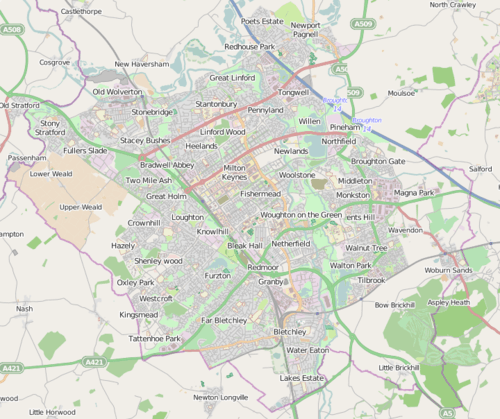
East of Northampton, the road passes Little Houghton, Brafield-on-the-Green and Yardley Hastings. After here it enters the borough of Milton Keynes where it meets the A509 at Warrington roundabout. Continuing towards Bedford, the road passes Lavendon and Cold Brayfield. Crossing the Great Ouse it enters Bedfordshire at Turvey, on to Bromham. It meets the A422 at a roundabout outside Bromham. The road bypasses Bromham and, leaving behind its former route east-bound through Bedford (which has become the A4280), swings southwards on a new alignment then, via a new bridge over the Great Ouse, merges with the A421 south of Kempston.
The A428 loses its identity here: the route continues as the A421 as it bypasses Bedford, Great Barford and Roxton and goes on to become the dual-carriageway A1 at the Black Cat Roundabout. Heading north, the route leaves the A1 via a grade separated junction just south of St Neots and regains its identity. Crossed by the East Coast Main Line, it leaves Bedfordshire for Cambridgeshire. The A428 from here to Cambridge follows the former A45, which became the A428 when the A14 opened. It meets the A1198 (former A14) at Caxton Gibbet roundabout near Papworth Everard. From here the road is dual carriageway, bypassing the existing single carriageway section near Hardwick. The route terminates, merging into the A14 at Girton interchange, where traffic joins first from the M11 junction 14 and then from the trunk A14 road junction 31.
Proposed developments
Oxford to Cambridge Expressway
In the "Road investment strategy" announced to Parliament by the Department for Transport and Secretary of State for Transport on 1 December 2014, planning will begin to dual the section between the A1 and the A1198 at Caxton Gibbet.[2] The announcement said that the A1/A421 Black Cat Roundabout would be replaced with a grade-separated junction,[2] just a few years after this roundabout was expensively upgraded. The link would provide an uninterrupted dual carriageway route between the M1 at Junction 13 and the A14 near Cambridge, part of a longer-term proposal to establish an "Oxford to Cambridge Expressway", via (or near) Milton Keynes.[2]
History
The section between Cambridge and the A1 was originally part of the A45.
Bypasses and realignments
- Crick (Bypassed, now unclassified)
- West Haddon (Bypassed, now unclassified)
- Little Houghton (Bypassed, now unclassified) (the 2-mile (3.2 km) £1.4 million bypass opened in December 1979)
- Bromham (the 2-mile (3.2 km) £4.8 million bypass opened in September 1986)[3]
- Bedford - The first section of the Bedford Western Bypass opened December 2009. The route, 3.2 miles (5.1 km) in length, commences at the Bromham Bypass on the east side of the river for approximately 1 mile (1.6 km). It then passes southwards crossing the River Great Ouse flood plain and bypasses Kempston to meet the A421 (A1-M1 link). The original route through Bedford was reclassified as the A4280.
- St Neots bypass (opened in December 1985, originally designated as the A45. The former route through the town is now the B1428).
- Eltisley bypass (opened in 1972, originally designated as the A45).
Recent Improvements
- Cambourne: Bypassed by a 1.2 miles (1.9 km) stretch of dual carriageway opened in May 2003.
- Caxton Gibbet: A two-lane £55 million dual carriageway section opened on 24 May 2007 after widening works started by the Highways Agency in August 2005,[4] linking this point to a grade-separated junction at Hardwick (about 5 miles (8 km) further east).[5]
References
| Wikimedia Commons has media related to A428 road (England). |
- ↑ "Directions to A428". Google. Retrieved 11 April 2013.
- 1 2 3 "The east of England gets a £1.5 billion investment in its roads as part of the new 'Road investment strategy'. 1 December 2014".
- ↑ "Bromham Timeline". Bedford Borough and Central Bedfordshire Libraries. 23 May 2008. Archived from the original on 7 October 2007. Retrieved 11 April 2013.
- ↑ "£55m 'commuter relief' road opens". BBC. 24 May 2007. Retrieved 11 April 2013.
- ↑ "Highways Agency". Archived from the original on 16 October 2006.
| Road |
| ||||||||||||||
|---|---|---|---|---|---|---|---|---|---|---|---|---|---|---|---|
| Rail |
| ||||||||||||||
| Air | |||||||||||||||
| Waterways |
| ||||||||||||||
| Footpaths |
| ||||||||||||||
| Cycle paths | |||||||||||||||
| Related articles |
| ||||||||||||||