Dover
| Dover | |
|---|---|
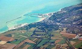 Aerial view of Dover Harbour | |
 Dover Dover shown within Kent | |
| Population | 31,022 (2011 Census)[1] |
| OS grid reference | TR315415 |
| • London | 77.8 miles (125.2 km) |
| Civil parish |
|
| District | |
| Shire county | |
| Region | |
| Country | England |
| Sovereign state | United Kingdom |
| Post town | DOVER |
| Postcode district | CT16, CT17 |
| Dialling code | 01304 |
| Police | Kent |
| Fire | Kent |
| Ambulance | South East Coast |
| EU Parliament | South East England |
| UK Parliament | |
Dover (/ˈdoʊvər/) is a town and major ferry port in the home county of Kent, in South East England. It faces France across the Strait of Dover, the narrowest part of the English Channel, and lies south-east of Canterbury and east of Maidstone. The town is the administrative centre of the Dover District and home of the Dover Calais ferry through the Port of Dover. The surrounding chalk cliffs are known as the White Cliffs of Dover.
Archaeological finds have revealed that the area has always been a focus for peoples entering and leaving Britain. The name of the town derives from the name of the river that flows through it, the River Dour.
Although many of the former ferry services have declined, services related to the Port of Dover provide a great deal of the town’s employment, as does tourism. A plan to privatise the port was scrapped in 2012 due to local opposition.[3]
Etymology
First recorded in its Latinised form of Portus Dubris, the name derives from the Brythonic word for waters (dwfr in Middle Welsh; dowr in Cornish[4]). The same element is present in the town's French (Douvres) and Modern Welsh (Dofr) forms, as well as the name of the river Dour and is evident in other English towns such as Wendover.
The current name was in use at least by the time of Shakespeare's King Lear (between 1603 and 1606), in which the town and its cliffs play a prominent role. The sight of the white cliffs when approaching Dover may have given the island of Britain its ancient name of Albion.
History
.JPG)
.jpg)
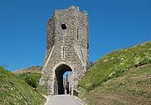
Archaeological finds have shown that there were Stone Age people in the area, and that some Iron Age finds also exist.[5] During the Roman period, the area became part of the Roman communications network. It was connected by road to Canterbury and Watling Street and it became Portus Dubris, a fortified port. Dover has a partly preserved Roman lighthouse (the tallest surviving Roman structure in Britain) and the remains of a villa with the only preserved Roman wall painting outside Italy.[6] Dover later figured in the Domesday Book.
Forts were built above the port and lighthouses were constructed to guide passing ships. It is one of the Cinque Ports.[7] and has served as a bastion against various attackers: notably the French during the Napoleonic Wars and Germany during the Second World War.
Geography and climate
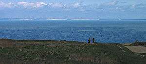
Dover is in the south-east corner of Britain. From South Foreland, the nearest point to the European mainland, Cap Gris Nez is 34 kilometres (21 mi) away across the Strait of Dover.[8]
The site of its original settlement lies in the valley of the River Dour, sheltering from the prevailing south-westerly winds. This has led to the silting up of the river mouth by the action of longshore drift. The town has been forced into making artificial breakwaters to keep the port in being. These breakwaters have been extended and adapted so that the port lies almost entirely on reclaimed land.
The higher land on either side of the valley – the Western Heights and the eastern high point on which Dover Castle stands – has been adapted to perform the function of protection against invaders. The town has gradually extended up the river valley, encompassing several villages in doing so. Little growth is possible along the coast, since the cliffs are on the sea’s edge. The railway, being tunnelled and embanked, skirts the foot of the cliffs.
Dover has an oceanic climate (Koppen classification Cfb) similar to the rest of the United Kingdom with mild temperatures year-round and a light amount of rainfall each month. The warmest recorded temperature was 31 °C (88 °F) and the coldest was −8 °C (18 °F), but the temperature is usually between 3 °C (37 °F) and 21.1 °C (70.0 °F). There is evidence that the sea is coldest in February; the warmest recorded temperature for February was only 13 °C (55 °F), compared with 16 °C (61 °F) in January.
| Climate data for Dover Harbour (Beach), elevation: 0m (1981-2010) | |||||||||||||
|---|---|---|---|---|---|---|---|---|---|---|---|---|---|
| Month | Jan | Feb | Mar | Apr | May | Jun | Jul | Aug | Sep | Oct | Nov | Dec | Year |
| Record high °C (°F) | 16 (61) |
13 (55) |
18 (64) |
23 (73) |
26 (79) |
28 (82) |
31 (88) |
31 (88) |
25 (77) |
24 (75) |
16 (61) |
14 (57) |
31 (88) |
| Average high °C (°F) | 7.8 (46) |
7.8 (46) |
10.1 (50.2) |
11.9 (53.4) |
15.7 (60.3) |
18.2 (64.8) |
20.7 (69.3) |
21.1 (70) |
18.8 (65.8) |
15.4 (59.7) |
11.4 (52.5) |
8.4 (47.1) |
14.0 (57.2) |
| Daily mean °C (°F) | 5.6 (42.1) |
5.4 (41.7) |
7.4 (45.3) |
9.1 (48.4) |
12.5 (54.5) |
15.2 (59.4) |
17.5 (63.5) |
17.8 (64) |
15.8 (60.4) |
12.6 (54.7) |
8.9 (48) |
6.2 (43.2) |
11.2 (52.2) |
| Average low °C (°F) | 3.3 (37.9) |
3.0 (37.4) |
4.6 (40.3) |
6.3 (43.3) |
9.3 (48.7) |
12.1 (53.8) |
14.3 (57.7) |
14.5 (58.1) |
12.8 (55) |
9.8 (49.6) |
6.4 (43.5) |
4.0 (39.2) |
8.4 (47.1) |
| Record low °C (°F) | −5 (23) |
−8 (18) |
−4 (25) |
−1 (30) |
1 (34) |
5 (41) |
6 (43) |
8 (46) |
6 (43) |
1 (34) |
−3 (27) |
−6 (21) |
−8 (18) |
| Average precipitation mm (inches) | 74.9 (2.949) |
59.4 (2.339) |
51.5 (2.028) |
60.0 (2.362) |
50.9 (2.004) |
56.2 (2.213) |
49.5 (1.949) |
57.6 (2.268) |
67.4 (2.654) |
101.9 (4.012) |
102.2 (4.024) |
85.3 (3.358) |
816.8 (32.157) |
| Average precipitation days (≥ 1.0 mm) | 12.3 | 10.6 | 10.6 | 10.5 | 8.1 | 8.2 | 8.2 | 8.0 | 10.2 | 11.6 | 12.6 | 12.7 | 123.5 |
| Average relative humidity (%) | 88 | 86 | 84 | 81 | 83 | 84 | 84 | 82 | 82 | 84 | 87 | 88 | 84 |
| Mean monthly sunshine hours | 66.0 | 83.4 | 117.5 | 185.2 | 214.7 | 213.3 | 221.6 | 223.4 | 159.4 | 126.0 | 76.7 | 55.8 | 1,743 |
| Source #1: Met Office[9] | |||||||||||||
| Source #2: weather2[10] | |||||||||||||
Demography
In 1800, the year before Britain's first national census, Edward Hasted (1732–1812) reported that the town had a population of almost 10,000 people.[11]
At the 2001 census, the town of Dover had 28,156 inhabitants, while the population of the whole urban area of Dover, as calculated by the Office for National Statistics, was 39,078 inhabitants.[12]
With the expansion of Dover, many of the outlying ancient villages have been incorporated into the town. Originally the parishes of Dover St. Mary's and Dover St. James, since 1836 Buckland and Charlton have become part Dover, and Maxton (a hamlet to the west), River, Kearsney, Temple Ewell, and Whitfield, all to the north of the town centre, are within its conurbation.
Economy
Shipping
.JPG)
The Dover Harbour Board[13] is the responsible authority for the running of the Port of Dover. The English Channel, here at its narrowest point in the Straits of Dover, is the busiest shipping lane in the world. Ferries crossing between here and the Continent have to negotiate their way through the constant stream of shipping crossing their path. The Dover Strait Traffic Separation Scheme allots ships separate lanes when passing through the Strait. The Scheme is controlled by the Channel Navigation Information Service based at Maritime Rescue Co-ordination Centre Dover. MRCC Dover is also charged with co-ordination of civil maritime search and rescue within these waters.[14]
The Port of Dover is also used by cruise ships. The old Dover Marine railway station building houses one passenger terminal, together with a car park. A second, purpose built, terminal is located further out along the pier.[15]
The ferry lines using the port are (number of daily sailings in parentheses):
- to Calais: P&O Ferries (25), DFDS Seaways (10).
- to Dunkirk: DFDS Seaways (11).
These services have been cut in recent years:
- P&O Ferries sailings to Boulogne (5 daily) were withdrawn in 1993 and Zeebrugge (4 daily) in 2002.
- SNCF withdrew their three train ferry sailings on the opening of the Channel Tunnel.
- Regie voor Maritiem Transport[16][17] moved their Ostend service of three sailings daily to Ramsgate in 1994; this route was operated by TransEuropa Ferries until April 2013.
- Stena Line merged their 20 Calais sailings into the current P&O operation in 1998.
- Hoverspeed ceased operations in 2005 and withdrew their 8 daily sailings.
- SpeedFerries ceased operations in 2008 and withdrew their 5 daily sailings.
- LD Lines ceased the Dover-Dieppe service on 29 June 2009 and Dover-Boulogne 5 September 2010.
- SeaFrance ceased operations in 2012 of their Dover-Calais service which was their only service.
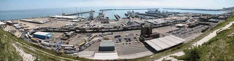
Dover Harbour, from the cliffs above.
Transport
Dover’s main communications artery, the A2 road replicates two former routes, connecting the town with Canterbury. The Roman road was followed for centuries until, in the late 18th century, it became a toll road. Stagecoaches were operating: one description stated that the journey took all day to reach London, from 4 am to being "in time for supper".[18]
The other main roads, travelling west and east, are the A20 to Folkestone and thence to London and the A258 through Deal to Sandwich.
The railway reached Dover from two directions: the South Eastern Railway's main line connected with Folkestone in 1844, and the London, Chatham and Dover Railway opened its line from Canterbury in 1861. Southeastern trains run from Dover Priory to London Charing Cross, London Victoria or London St Pancras International stations in London, and Ramsgate or Sandwich in Kent.
A tram system operated in the town from 1897 to 1936.
Dover has two long distance footpaths: the Saxon Shore Way and the North Downs Way. Two National Cycle Network routes begin their journey at the town.
The Port of Dover is a 20-minute walk from Dover Priory railway station.
The Dover to Dunkirk ferry route was originally operated by ferry operator Norfolkline. This company was later acquired by the pan European operator DFDS Seaways in July 2010.[19] The crossing time is approximately two hours.[20] Due to this route not being as well known as Dover to Calais, prices are often cheaper.[21] The location of Dunkirk is also more convenient for those travelling by road transport on to countries in Northern Europe including Belgium, the Netherlands, Germany and further afield.
Stagecoach in East Kent provide local bus services. Dover is on the Stagecoach Diamond network providing links to Canterbury and Deal. The Western Docks at the port of Dover are served from the town centre as well as Canterbury and Deal. Dover is the start of The Wave network to New Romney via Folkestone, Hythe and Dymchurch. There are services to Lydd via Lydd Airport, with one continuing from Lydd on to Hastings via Camber and Rye. There is a link to Sandwich and Ramsgate. Buses run from Dover to Canterbury via Aylesham.
National Express runs coaches from Dover to other towns in Kent including Canterbury, Folkestone, Ashford, Kent, Maidstone, Gillingham at Hempsted Valley shopping centre and Greenhithe at Bluewater Shopping Centre for Dartford to London including Bexleyheath, Eltham, Walworth, Canary Wharf, Elephant & Castle, The City (The City of London) and to Victoria Coach Station
All buses serve Pencester Road except route 68 to Maxton operated by Regent Coaches.
Retail
The town's main shopping streets are the High Street and Biggin Street. The Castleton Retail Park is to the north-west of the town centre.
RNLI
The Dover lifeboat is a Severn class lifeboat based in the Western Docks.[22] Dover Lifeboat station is based at crosswall quay in Dover Harbour. There is a Severn-class lifeboat, which is the biggest in the fleet. It belongs to the RNLI which covers all of Great Britain. The lifeboat number is 17-09 and has a lot of emergencies in the Channel. The Severn class is designed to lay afloat. Built from fibre reinforced composite (FRC) the boat is lightweight yet very strong and is designed to right itself in the event of a capsize.
Education
There are nine secondary level schools, 16 primary schools and two schools for special education.
Non-selective secondary schools include Astor College, St Edmund's Catholic School and Dover Christ Church Academy. Dover Grammar School for Boys and Dover Grammar School for Girls are the main grammar schools for the town.
Astor College for the Arts federated with St Radigunds Primary School (then renamed White Cliffs Primary College for the Arts) to form the Dover Federation for the Arts (DFA). Subsequently, Barton Junior School and Shatterlocks Nursery and Infant School joined the DFA. Two schools have been rated by OFSTED as Outstanding and two Good with outstanding features. In 2014 the Dover Federation for the Arts was warned by the Department for Education about "unacceptably low standards of performance of pupils ".[23]
The Duke of York's Royal Military School, England's only military boarding school for children of service personnel (co-ed ages 11–18), is also located in Dover, next to the former site of Connaught Barracks.
Dover College, a public school was founded in 1871 by a group of local business men.[24]
Public services
Dover has one hospital, Buckland Hospital[25] built in 2015 and located just along from its previous location ( A former Victorian workhouse) on Coombe Valley Road. The town once had four hospitals, Buckland, Royal Victoria, Isolation and the Eye Hospitals located at various points across the town.
Local media
Television
Dover was the home to television studios and production offices of Southern Television Ltd, the company which operated the ITV franchise for South and South East England from 1958-1981. The studios were located on Russell Street and were home to programmes like 'Scene South East', 'Scene Midweek', 'Southern News', 'Farm Progress' and the nightly epilogue, 'Guideline'. The studios were operated by TVS in 1982 and home to 'Coast to Coast', however they closed a year later when the company moved their operations to the newly complete Television Centre in Maidstone.
Newspapers
Dover has two paid for newspapers, the Dover Express (published by Kent Regional News and Media) and the Dover Mercury (published by the KM Group). Free newspapers for the town include the Dover and Deal Extra, part of the KM Group; and yourdover, part of KOS Media.
Radio
Dover has one local commercial radio station, KMFM Shepway and White Cliffs Country, broadcasting to Dover on 106.8FM. The station was founded in Dover as Neptune Radio in September 1997 but moved to Folkestone in 2003 and was consequently rebranded after a takeover by the KM Group. Dover is also served by the county-wide stations Heart, Gold and BBC Radio Kent.
The Gateway Hospital Broadcasting Service, in Buckland Hospital radio, closed at the end of 2006. It was the oldest hospital radio station in East Kent being founded in 1968.[26]
Dover Community Radio (DCR) currently offer internet programming and podcasts on local events and organisations on their website. The online station of the same name launched on 30 July 2011 offering local programmes, music and news for Dover and district.[27]
Culture
There are three museums: the main Dover Museum,[28] the Dover Transport Museum[29] and the Roman Painted House.[30]
Twin towns
Sports
Dover Leisure Centre on Townwall Street, is operated by Your Leisure, a not for profit charitable trust,[33] which caters for sports and includes a swimming pool.
There are sports clubs, amongst them Dover Athletic F.C., who play in the conference Premier league; rugby; swimming; water polo and netball (Dover and District Netball League).[34]
Dover Rowing Club is the oldest coastal rowing club in Britain and has a rich history, at one time becoming the best club on the south coast. More information can be found on the history page of the club's website.[35]
One event which gets media attention is that of swimming the English Channel.[36]
Sea fishing, from the beach, pier or out at sea, is carried out here.[37] The so-called Dover sole (solea solea) is found all over European waters.
Places of interest
- Blériot memorial: the outline of Louis Blériot's aircraft, marked with granite setts, at the exact spot where Blériot landed after the first cross-Channel flight, 1909[38]
- Dover Castle
- White Cliffs of Dover
- Dover Western Heights
- Dover Museum
- Roman Painted House Museum
- Samphire Hoe
- South Foreland Lighthouse
- Pines Garden
- St Edmund's Chapel
- St Mary's Church
- St James' Church: preserved as a "tidy ruin"
- St Paul's Church
Notable people
In literature
M.R. James used the Dover landmark, the Lord Warden Hotel, as a location in his short ghost story "Casting the Runes", first published in More Ghost Stories in 1911.
Matthew Arnold used the setting of Dover in his famous 19th-century poem, "Dover Beach."
See also
References
- ↑ "Town population 2011". Retrieved 3 October 2015.
- ↑ "Dover Town Council". dovertowncouncil.gov.uk.
- ↑ Neate, Rupert (20 December 2012). "White cliffs of Dover: locals repel buyout by the French". The Guardian. Retrieved 21 November 2017.
- ↑ "English Words - cornish dictionary / gerlyver kernewek". www.cornishdictionary.org.uk.
- ↑ "Archaeology". The Dover Society. Retrieved 30 March 2018.
- ↑ "Roman Dover". Dover: Lock and Key of the Kingdom. Retrieved 30 March 2018.
- ↑ Oldfield, Thomas Hinton Burley. (1794). An entire and complete history, political and personal, of the boroughs of Great Britain: Together with the Cinque Ports, 2d ed. corr. and improved. London: B. Crosby.
- ↑ "Eosnap.com". Eosnap.com. Retrieved 26 August 2011.
- ↑ "Dover 1981–2010 averages". Met Office. Retrieved 4 November 2012.
- ↑ "Dover climate". weather2. Retrieved 8 November 2011.
- ↑ "Hasted description of Dover". British-history.ac.uk. 29 January 1998. Retrieved 26 August 2011.
- ↑ "KS01 Usual resident population: Census 2001, Key Statistics for urban areas". National Statistics. Archived from the original on 11 March 2005. Retrieved 8 June 2007.
- ↑ "Dover Harbour Board". Doverport.co.uk. Retrieved 26 August 2011.
- ↑ "The Dover Strait Traffic Navigation Scheme and rules relating thereto". Mcga.gov.uk. Retrieved 26 August 2011.
- ↑ "Cruise Port Passenger Guide" (PDF). Port of Dover. Archived from the original (PDF) on 12 July 2014. Retrieved 18 July 2012.
- ↑ Ostende ferry Archived 23 May 2009 at the Wayback Machine.
- ↑ "Telenet.be". Users.telenet.be. 19 September 1996. Archived from the original on 9 June 2011. Retrieved 26 August 2011.
- ↑ "From The Life of Thomas Telford". Worldwideschool.org. Archived from the original on 26 September 2006. Retrieved 26 August 2011.
- ↑ "DFDS Seaways acquires Norfolkline". DFDS Seaways. Retrieved 16 December 2013.
- ↑ "Norfolk Line Ferries | Book Norfolk Line Ferries | Timetable, Offers, Reviews & Routes". AFerry.co.uk. Retrieved 26 March 2013.
- ↑ Travel advice. "Travel advice: cheap ferry crossings to France". Telegraph. Retrieved 26 March 2013.
- ↑ "The Dover lifeboat". The Dover lifeboat. 7 August 2011. Retrieved 26 August 2011.
- ↑ "Academy trusts: notices about poor performance - GOV.UK".
- ↑ "Dover College". Dover College. Archived from the original on 22 December 2014. Retrieved 26 August 2011.
- ↑ Buckland Hospital
- ↑ "GHBS closure".
- ↑ "Dover Community Radio Website". Dovercommunityradio.co.uk. 31 July 2011. Retrieved 26 August 2011.
- ↑ "Dover Museum website". Dover.gov.uk. Archived from the original on 16 March 2013. Retrieved 26 August 2011.
- ↑ "Dover Transport Museum". White Cliffs County. Dover District Council. Retrieved 23 August 2015.
- ↑ "The Roman Painted House, Dover- Homepage". Theromanpaintedhouse.co.uk. Archived from the original on 6 November 2011. Retrieved 26 August 2011.
- ↑ "British towns twinned with French towns [via WaybackMachine.com]". Archant Community Media Ltd. Archived from the original on 5 July 2013. Retrieved 20 July 2013.
- ↑ "Gradovi prijatelji Splita" [Split Twin Towns]. Grad Split [Split Official City Website] (in Croatian). Archived from the original on 24 March 2012. Retrieved 19 December 2013.
- ↑ "Dover Leisure Centre". Vistaleisure.com. Archived from the original on 17 July 2011. Retrieved 26 August 2011.
- ↑ "Netaball league". Doveranddistrictnetballleague.co.uk. Retrieved 26 August 2011.
- ↑ "Dover Rowing Club History".
- ↑ Whyte Studio. "Channel Swimming". Dover.uk.com. Retrieved 26 August 2011.
- ↑ "Sea Fishing". Doverpages.co.uk. Archived from the original on 29 September 2011. Retrieved 26 August 2011.
- ↑ "Dover Aeroplane". Hows.org.uk. Retrieved 18 April 2010.
Bibliography
- Statham, S.P.H. (1899). The history of the castle, town, and port of Dover. London: Longmans Green & Co. pp. 462 p.
- Foot, William (2006). Beaches, fields, streets, and hills ...: the anti-invasion landscapes of England, 1940. CBA research report 144. York: Council for British Archaeology. ISBN 1-902771-53-2.
External links
| Wikimedia Commons has media related to Dover. |
| Wikisource has the text of a 1911 Encyclopædia Britannica article about Dover. |
| Wikivoyage has a travel guide for Dover. |
- UKHO nautical charts of Dover and approaches
- Dover Street Map
- The Dover War Memorial Project
- Western Heights Preservation Society
- Friends of Dover Castle A scheme for the local people of Dover to contribute and benefit from their Castle.


Kent Portal | |
| Unitary authorities | |
| Boroughs or districts | |
| Major settlements |
|
| Rivers | See: Rivers of Kent |
| Topics | |