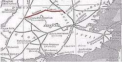
Akeman Street

Akeman Street was a major Roman road in England that linked Watling Street with the Fosse Way. Its junction with Watling Street was just north of Verulamium (near modern St Albans) and that with the Fosse Way was at Corinium Dobunnorum (now Cirencester). Its course passes through towns and villages including Hemel Hempstead, Berkhamsted, Tring, Aylesbury, Alchester (outside modern Bicester), Chesterton, Kirtlington, Ramsden and Asthall. [1]
Parts of the A41 road between Berkhamsted and Bicester use the course of the former Roman road, as did the Sparrows Herne turnpike between Berkhamsted and Aylesbury. A minor road between Chesterton and Kirtlington also uses its course. Other parts are in use as public footpaths, including a 6-mile (9.7 km) stretch between Tackley and Stonesfield that is part of the Oxfordshire Way.
The origins of the road's name are uncertain but certainly date back to the Early Middle Ages. Some have suggested that "Akeman" derives from the Anglo-Saxon words for "oak-man". Others have suggested a connection with Bath, which the Anglo-Saxons called Acemannesceastre (Acemannes apparently being derived from the Roman name Aquae Sulis). It is unclear how this might have become associated with the road, but one possibility is that the name was originally used for the longer stretch of road from Bath.[2]
The name "Akeman Street" is also given to the Roman road that ran from Ermine Street near Wimpole Hall northeast to the settlement at Durolipons (Cambridge), where it crossed the Roman road known as the Via Devana. Within north Cambridge, the road followed the present-day Stretten Avenue, Carlton Way and Mere Way running northeast past Landbeach before joining the present A10 and on towards Ely and The Fens. It then reached Denver and the coast at Brancaster.[3]
References
- ↑ Copeland, Tim (2009). Akeman Street Moving Through Iron Age and Roman Landscapes. History PressLtd. ISBN 978-0-7524-4732-2.
- ↑ Saxon Bath
- ↑ Gray, Ronald D; Stubbings, Derek (2000). Cambridge Street-Names: Their Origins and Associations. Cambridge: Cambridge University Press. pp. 2–3.
See also
- Roman Britain
- Roman roads in Britain
- RAF Akeman Street, near Minster Lovell, named as the Roman Road crosses the World War II airfield
Bibliography
- Copeland, Tim (2009). Akeman Street Moving Through Iron Age and Roman Landscapes. History PressLtd. ISBN 978-0-7524-4732-2.
Coordinates: 51°53′10″N 1°11′31″W / 51.88624°N 1.19202°W
| Authority control |
|---|