Preston By-pass
| Preston By-pass motorway | |
|---|---|
 Shown in blue | |
| Route information | |
| Length | 8.26 mi (13.29 km) |
| History | Opened in 1958 |
| Major junctions | |
| South end | Bamber Bridge |
| North end | Broughton |
| Road network | |
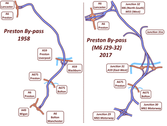
The Preston By-pass was Britain's first motorway. It was designed and engineered by Lancashire County Council surveyor James Drake as part of a larger initiative to create a north-south motorway network that would later form part of the M6 motorway. The by-pass was opened on 5 December 1958 by the Prime Minister, Harold Macmillan. Nearly £3 million was spent in its construction. The original 8 1⁄4-mile (13.3 km) motorway ran around the east side of Preston between Bamber Bridge (now the M6, Junction 29) and Broughton (now the M55, Junction 1) and crosses over the River Ribble at Samlesbury at the M6 Junction 31.
Planning started in 1937, despite there being no legal powers that permitted motorway construction until the introduction of the Special Roads Act 1949. Early work was hampered by heavy rainfall, resulting in postponement of various heavy engineering works such as the base foundation; the result of the weather meant the original two-year plan was delayed by a further five months. Weeks after opening, the road had to temporarily close due to water causing further problems, when the base layer was damaged as a result of a rapid freeze and thaw cycle.
The by-pass has undergone two separate lane-widening schemes during its existence, firstly in 1966 when it was widened to three lanes, then in the 1990s to expand it to four lanes in each direction. The latter upgrade was significant enough to require reconstruction of the entire route including all bridges and it is now effectively a different motorway from the one that opened in 1958.
History
Planning
Before the motorway was constructed, the A6 road through Preston handled north-south traffic with tailbacks and congestion a common occurrence, more so during special occasions such as the Blackpool Illuminations. The route had been planned as far back as 1937–1938,[1] with the basic alignment still deemed feasible by the time Lancashire County Council gave approval in the mid 1940s. Chief engineer Drake was part of a delegation from Lancashire that travelled to Germany in 1938 in order that a plan could be drawn up by the council. The agreed route formed part of the County Surveyors' Society's national proposals and was protected by Lancashire County Council from any future developments.[2] During planning, the legal powers necessary for motorway construction did not exist, until the introduction of the Special Roads Act in 1949 that made it lawful to construct roads that were to be used only by certain classes of vehicle.[3] The by-pass was seen as an experiment for the future motorway construction, with many lessons and techniques were learned that would help towards successful future projects. When the proposals were made public, including a large-scale model to ease the explaining of the scheme, only a handful of formal objections were raised and were resolved by agreement without the need to initiate a public inquiry, cited in part because of close personal involvement of Lancashire County Council and the surveyor during consultation.[4]
The Tarmac Group (now Carillion) won the construction bid in 1956, including 19 bridges; John Cox was the onsite engineer assigned by the contractor to oversee the construction.[5]
Construction

The road was originally built with two lanes in each direction, but with an unusually wide central reservation to accommodate a third lane to be added each way at a later date. The work was a compromise between the Ministry of Transport and Drake, the latter who thought two lanes would not be adequate. Initially, the shoulders were hardened with gravel but not paved,[6] a fact still reflected in the British term hard shoulder. A hedge was planted along the length of the central reservation to help reduce dazzle from the headlights of oncoming traffic at night. The road was constructed to not be a long length of straight road and with the addition of various bridges and tree planting, in the hope to prevent driver boredom reported on foreign motorways.[3]
The earth material used for the embankments was planned to come from the road foundation works, but rainfall meant it was no longer fit for purpose and had to be imported instead. In total, 3,400,000 tonnes (3,300,000 long tons; 3,700,000 short tons) of earth was excavated, with a further 668,000 tonnes (657,000 long tons; 736,000 short tons) of material imported for filling.[3] The sub-base consisted of burnt red shale with thickness dependent upon the ground conditions, followed by a layer of wet mix around 9 inches (23 cm) thick and topped with 2–3 inches (approximately 6.4 cm) of tarmac lined with 0.5-1 inches (approximately 1.9 cm) of asphalt. A total of 22 bridges were required in construction, and designers were given relative freedom in planning them. Chief engineer Drake proposed the bridges be painted different colours to enhance aesthetics and help alleviate driver boredom, contrary to conventional practice of using neutral colours; drivers subsequently reacted favourably to alternately coloured bridges.[4]
The contracted period for construction was planned to be around two years, but the timescale was lengthened by nearly 25% due to rainfall that persisted throughout much of the early construction period. The heavy rainfall in late 1956 had profound effects on the heavy engineering works required to construct the road foundation, resulting in this aspect of work being postponed until early 1957; an extension of five months was granted due to the extraordinary and unforeseen weather conditions.[3] Numerous lessons were learnt from the construction of Britain's first motorway, particularly towards using an appropriately screened base material, with water drainage systems that should be appropriate and fit for purposes, as well as the inclusion of continuous hard shoulders.[4]
Opening
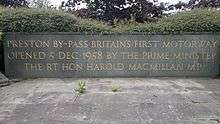
The by-pass was opened on 5 December 1958 by the Prime Minister, Harold Macmillan. It had cost £2,960,481 (equivalent to £63,473,943 in 2016), of which almost £2.5m was for construction of the motorway itself and over £500,000 was for the construction of two required major bridges, those being the Samlesbury Bridge (£334,431) and the High Walton Bridge (£193,690) respectively.[3] Macmillan became the first man in Britain to travel on a motorway, as a passenger in an Austin Sheerline limousine, setting off from what is now junction 31 on the M6 motorway.[7] Many hundreds of people gathered at the interchange in Samlesbury to witness the official opening, of whom many had participated in the construction and were proud of what they had achieved.[5]
Operation

The motorway was designed to be capable of handling vehicles at speeds of 70 mph (110 km/h),[4] a limit which is unchanged to this day; no speed limit was enforced for the first few years. Lancashire Police estimated that 2,300 cars were using the road each day within the first month of opening, which was considerably less than the road's capacity.[8] During the early period of operation, drivers reported being apprehensive about using the motorway through fear of faster drivers over-taking them, with average speeds recorded as being around 38 mph (61 km/h),[9] despite police records for the month ending 23 May 1959 showing no vehicle being driven faster than 75 mph (121 km/h).[10] Shortly after opening, the motorway saw its first two minor incidents; each was as a result of inexperienced drivers (in one case, an underage driver) being unfamiliar with motorway driving and losing control of their vehicles.[11]
On 21 January 1959, just 46 days after opening,[5] the motorway had to temporarily close to undergo emergency resurfacing work, as water had drained into the hard shoulder and seeped into the base layer. This subsequently suffered as a result of frost weathering, resulting in crumbling road parts[6] affecting approximately 1% of the surface.[12] The cost of repairs was around £5,000 (equivalent to £106,755 in 2016), as quoted by then-Minister of Transport and Civil Aviation Harold Watkinson; additional drainage systems were also installed alongside the carriageway at a cost of £90,000 (equivalent to £1,921,584 in 2016).[13]
Upgrades
An additional third lane was added in each direction in 1966 using the land reserved within the central reservation, without the need to modify existing bridges. Despite the relative ease in this work, the lack of hard shoulders at the bridges meant the number of available lanes during engineering works was inadequate to cope with the traffic volumes of the time, estimated to be have been in the region of 140,000 vehicles daily.[4] Construction of the M61 motorway in 1969–1970 to carry Manchester traffic northbound had its northern terminus connect to a new junction on the by-pass at Bamber Bridge, requiring the construction of Blacow Bridge to carry the north-bound M61 traffic over the M6.[14]
The bypass underwent significant work during the early 1990s, when it was completely rebuilt to become 4 lanes in each direction. All of the bridges needed removing so a hard shoulder could be provided, despite most of them having a design lifespan of 120 years.[5] The bid to undertake the work was awarded to Balfour Beatty in February 1993, at a cost of £37,458,986 (equivalent to £70,024,333 in 2016).[15] The upgrade meant that the bypass was entirely reconstructed and is now effectively a different motorway to the original bypass.[16] The 4-lane motorway had been initially proposed back in 1924, when the idea was quickly dismissed after pressure mounted from railway lobbyists.[17]
Route
Despite the motorway passing through industrial areas, the proposed route alignment meant that property demolition was kept to a minimum, with just a single farmhouse and three dwellings requiring demolition. The route was constructed through four separate localities, including 1.65 mi (2.66 km) through the County Borough of Preston, 2.54 mi (4.09 km) through the Urban District of Walton-le-Dale, 1.77 mi (2.85 km) through the Urban District of Fulwood and 2.30 mi (3.70 km) through the Rural District of Preston.[3]
Initially, there were a total of 22 bridges built under or over the motorway, such as a principal bridge at Samlesbury which carried traffic over the River Ribble and the A59 trunk road, the only junction upon opening; the other principal bridge was at Higher Walton, carrying traffic over the River Darwen and the A675 road. The overall width of the motorway was 112 ft (34 m), 24 ft (7.3 m) for each carriageway, 14 ft (4.3 m) for the verges and a 32 ft (9.8 m) central reservation.[3]
The routes around the city of Preston, including the by-pass as part of the modern day M6 motorway, are recognised as being some of the most congested in the UK, with traffic to and from Preston being labelled amongst the country's top 25 most congested routes.[18]
| Preston By-pass | |||||
| mile | km | Northbound exits (A carriageway) | Junction | Southbound exits (B carriageway) | Coordinates |
|---|---|---|---|---|---|
| Continues as the M55 motorway to Blackpool, Fleetwood | |||||
| Preston, Garstang A6 | M55 J1 Broughton Roundabout |
Preston, Garstang A6 | |||
| 8.0 7.5 |
12.9 12.1 |
The Lakes, Lancaster M6 | M6 J32 |
The North, The Lakes, Lancaster M6 | 53°48′24″N 2°41′52″W / 53.806759°N 2.697787°W |
| 6 5.8 |
9.6 9.3 |
Preston (East), Longridge B6242 | M6 J31A | No access | 53°47′20″N 2°39′30″W / 53.788940°N 2.658262°W |
| 4.1 3.5 |
6.6 5.6 |
Preston (Central), Blackburn (North), Clitheroe A59 | M6 J31 | Preston (Central), Clitheroe A59 | 53°45′54″N 2°38′09″W / 53.764949°N 2.635903°W |
| 1.9 1.4 |
3.0 2.3 |
No access | M6 J30 | Manchester, Bolton M61 Leeds (M62) Blackburn (M65) |
53°44′04″N 2°38′52″W / 53.734320°N 2.647705°W |
| 0.4 0 |
0.7 0 |
Burnley, Blackburn, Preston (South) M65 | M6 J29 | Burnley, Blackburn M65 | 53°42′58″N 2°39′39″W / 53.716190°N 2.660751°W |
| Continues as the M6 motorway to Birmingham | |||||
| Only the contemporary Junction 31 existed on the original by-pass formation | |||||
See also
References
- ↑ Marshall, Chris. "Preston Bypass". cbrd.co.uk. Chris Marshall. Archived from the original on 10 March 2013. Retrieved 16 June 2014.
- ↑ "UK Motorways, 1958–2008". November 2008: 13. Retrieved 1 April 2017.
- 1 2 3 4 5 6 7 "Preston By-Pass – Official Opening Booklet" (PDF). Lancashire County Council. 5 December 1958. Archived from the original (PDF) on 5 March 2016. Retrieved 15 February 2017.
- 1 2 3 4 5 "M6 Preston By-pass (J29 to J32)". The Motorway Archive. Archived from the original on 15 February 2017. Retrieved 4 January 2017.
- 1 2 3 4 "Chapter 12. Britain's First Motorway: The Preston By-pass". The Motorway Archive. Archived from the original on 18 February 2017. Retrieved 17 February 2017.
- 1 2 "Marking 50 years of UK motorways". BBC News. 5 December 2008. Retrieved 15 February 2017.
- ↑ "The drive of our lives: 50 Years of Britain's motorways". The Independent. 24 November 2008. Retrieved 17 February 2017.
- ↑ Moran, Joe (27 May 2010). On Roads: A Hidden History. Profile Books. p. 179. ISBN 978-1-84668-060-1.
- ↑ Moran, Joe (27 May 2010). On Roads: A Hidden History. Profile Books. p. 174. ISBN 978-1-84668-060-1.
- ↑ "Special Roads Order 1959". Millbank Systems. 17 July 1959. Retrieved 1 April 2017.
- ↑ "Preston Bypass – A new era of motoring". CBRD. Archived from the original on 16 February 2017. Retrieved 15 February 2017.
- ↑ "Preston Bypass Closure, Written Answers (Commons)". Millbank Systems. 28 January 1959. Retrieved 29 March 2017.
- ↑ "Preston Bypass, Written Answers (Commons)". Millbank Systems. 4 February 1959. Retrieved 29 March 2017.
- ↑ "M61. Horwich Link to Preston". The Motorway Archive. 2009. Archived from the original on 31 March 2017. Retrieved 30 March 2017.
- ↑ "Road Construction Contracts 1994". Millbank Systems. 23 May 1994. Retrieved 17 February 2017.
- ↑ "Preston Bypass Epilogue". CRBD. Archived from the original on 20 February 2017. Retrieved 19 February 2017.
- ↑ "Preston Bypass, Timeline Item". Engineering Timelines. Retrieved 28 March 2017.
- ↑ "It's official: Preston is one of most congested cities in Britain". Lancashire Evening Post. 23 March 2016. Retrieved 4 January 2017.
External links
| Wikimedia Commons has media related to Preston By-pass. |
| Great Britain | .svg.png) | |||||
|---|---|---|---|---|---|---|
| Northern Ireland | ||||||
| Former | ||||||
| Unbuilt | ||||||
| Proposed | ||||||
| Junctions | ||||||
| Related articles | ||||||
| ||||||