Fenny Stratford railway station
| Fenny Stratford | |
|---|---|
 | |
| Location | |
| Place | Fenny Stratford |
| Local authority | Milton Keynes |
| Coordinates | 52°00′00″N 0°43′01″W / 52.000°N 0.717°WCoordinates: 52°00′00″N 0°43′01″W / 52.000°N 0.717°W |
| Grid reference | SP881342 |
| Operations | |
| Station code | FEN |
| Managed by | London Northwestern Railway |
| Number of platforms | 1 |
| DfT category | F2 |
|
Live arrivals/departures, station information and onward connections from National Rail Enquiries | |
| Annual rail passenger usage* | |
| 2012/13 |
|
| 2013/14 |
|
| 2014/15 |
|
| 2015/16 |
|
| 2016/17 |
|
| History | |
| 17 November 1846[1] | Opened |
| 22 May 1967 | Goods services withdrawn |
| 15 July 1968 | Became unstaffed[2] |
| National Rail – UK railway stations | |
| * Annual estimated passenger usage based on sales of tickets in stated financial year(s) which end or originate at Fenny Stratford from Office of Rail and Road statistics. Methodology may vary year on year. | |
|
| |
Fenny Stratford is a railway station that serves the Fenny Stratford area of Milton Keynes, Buckinghamshire. It is on the Marston Vale Line that links Bletchley and Bedford, about one mile (1.7 km) east of Bletchley railway station.
This station is one of five serving Milton Keynes. The others are Wolverton, Milton Keynes Central, Bletchley and Bow Brickhill.
Services
The station is served by London Northwestern's Bletchley – Bedford local services, calling hourly in each direction Mon-Sat (no Sunday service)[3] Services are run with Class 153 single car diesel multiple units and 2-car class 150 unit.
The station can be accessed from both Watling Street (via steps at Stag bridge) and Simpson Road (which is at grade), to the east and west of the station respectively,
| Preceding station | Following station | |||
|---|---|---|---|---|
| London Northwestern Railway Marston Vale Line Mondays-Saturdays only |
History
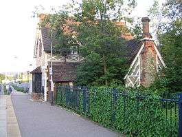
Opened in 1846 by the Bedford Railway,[1] Fenny Stratford station is just over 1 mile (1.6 km) from Bletchley. The station buildings are in a half-timbered Gothic Revival style that had been insisted upon by the 7th Duke of Bedford for stations close to the Woburn Estate. The buildings are now residential and Grade II listed.[4] West of the station is Watling Street, which was raised by some 6 feet 8 inches (2.03 m) to allow the railway to pass beneath; immediately west of Stag bridge in the direction of Bletchley are points leading onto the disused freight-only railway line toward Oxford via the Bletchley flyover. The passenger line and station are protected here by trap points, but they are sited such that any runaway train caught by it would subsequently crash into the bridge.[5]
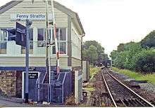
The station was originally built with staggered platforms, a wedge-shaped down platform being near the Simpson Road level crossing to the east. The platforms were rebuilt in 1948 so that they faced each other in the conventional side platform arrangement. One platform was taken out of service in the 1960s, as were a number of sidings. Fenny Stratford was reduced to an unstaffed halt in 1968, freight facilities having been withdrawn the previous year. As of March 2018, the station remains unstaffed. All that now remains is one platform and an area of wasteland east of the station, before Simpson Road crossing, which was controlled by a now demolished signal box that was taken out of service in 2004.
Accidents and incidents
There was an accident here on 7 December 1925 at 8.43 pm when a bus crashed through the closed crossing gates on Simpson Road and collided with the 6.30 pm train from Cambridge to Bletchley. Six people in the bus, including the driver, were killed instantly, and four others were seriously injured. The train, however, was undamaged.[5]
Marston Vale line
Fenny Stratford station, in common with others on the Marston Vale Line, is covered by the Marston Vale Community Rail Partnership,[6] which aims to increase use of the line by involving local people.
As of January 2016, the line through the station is single track (from Bletchley to just east of the A5, from whence it is double track until just short of Bedford St Johns).
Location
The station is on Watling Street near its junction with Aylesbury Street. The nearest post-code is MK2 2XE.[7] In the chainage notation traditionally used on the railway, it is 1 mile 1 chain (1.01 mi; 1.63 km) from Bletchley station on the line to Bedford.[8]
Stations in and around Milton Keynes | ||||||||||||||||||||||||||||||||||||||||||||||||||||||||||||||||||||||||||||||||||||||||||||||||||||||||||||||||||||||||||||||||||||||||||||||||||||||||||||||||||||||||||||||||||||||||||||||||||||||||||||||||||||||||||||||||||||||||||||||||||||||||||||||||||||||||||||||||||||||||||||||||||||||||||||||||||||||||||||||||||||||||||||||||||||||||||||||||||||||||||||||||||||||||||||||||||||||
|---|---|---|---|---|---|---|---|---|---|---|---|---|---|---|---|---|---|---|---|---|---|---|---|---|---|---|---|---|---|---|---|---|---|---|---|---|---|---|---|---|---|---|---|---|---|---|---|---|---|---|---|---|---|---|---|---|---|---|---|---|---|---|---|---|---|---|---|---|---|---|---|---|---|---|---|---|---|---|---|---|---|---|---|---|---|---|---|---|---|---|---|---|---|---|---|---|---|---|---|---|---|---|---|---|---|---|---|---|---|---|---|---|---|---|---|---|---|---|---|---|---|---|---|---|---|---|---|---|---|---|---|---|---|---|---|---|---|---|---|---|---|---|---|---|---|---|---|---|---|---|---|---|---|---|---|---|---|---|---|---|---|---|---|---|---|---|---|---|---|---|---|---|---|---|---|---|---|---|---|---|---|---|---|---|---|---|---|---|---|---|---|---|---|---|---|---|---|---|---|---|---|---|---|---|---|---|---|---|---|---|---|---|---|---|---|---|---|---|---|---|---|---|---|---|---|---|---|---|---|---|---|---|---|---|---|---|---|---|---|---|---|---|---|---|---|---|---|---|---|---|---|---|---|---|---|---|---|---|---|---|---|---|---|---|---|---|---|---|---|---|---|---|---|---|---|---|---|---|---|---|---|---|---|---|---|---|---|---|---|---|---|---|---|---|---|---|---|---|---|---|---|---|---|---|---|---|---|---|---|---|---|---|---|---|---|---|---|---|---|---|---|---|---|---|---|---|---|---|---|---|---|---|---|---|---|---|---|---|---|---|---|---|---|---|---|---|---|---|---|---|---|---|---|---|---|---|---|---|---|---|---|---|---|---|---|---|---|---|---|---|---|---|---|---|---|---|---|---|---|---|---|---|---|---|---|---|---|---|---|---|
| ||||||||||||||||||||||||||||||||||||||||||||||||||||||||||||||||||||||||||||||||||||||||||||||||||||||||||||||||||||||||||||||||||||||||||||||||||||||||||||||||||||||||||||||||||||||||||||||||||||||||||||||||||||||||||||||||||||||||||||||||||||||||||||||||||||||||||||||||||||||||||||||||||||||||||||||||||||||||||||||||||||||||||||||||||||||||||||||||||||||||||||||||||||||||||||||||||||||
References
- 1 2 "Disused Stations - Fenny Stratford"Disused Stations Site Record; Retrieved 11 January 2017
- ↑ Clinker, C.R. (1978). Clinker's Register of Closed Passenger Stations and Goods Depots in England, Scotland and Wales 1830-1977. Bristol: Avon-AngliA Publications & Services. p. 160. ISBN 0-905466-19-5.
- ↑ Table 64 National Rail timetable, May 2016
- ↑ English Heritage Grade II listed building status Retrieved 2009-10-19
- 1 2 Simpson 1981, p. 29.
- ↑ Marston Vale Community Rail Partnership
- ↑ Streetmap.co.uk
- ↑ Engineer's Line References: Bletchley south junction to Bedford RailwayCodes.org
Sources
- Simpson, Bill (1981). Oxford to Cambridge Railway. 2. Poole: Oxford Publishing Co. p. 29. ISBN 0-86093-121-8.
External links
- Train times and station information for Fenny Stratford railway station from National Rail
- Historic England. "Details from image database (45418)". Images of England.
o
Transport in Milton Keynes | ||
|---|---|---|
| Road | 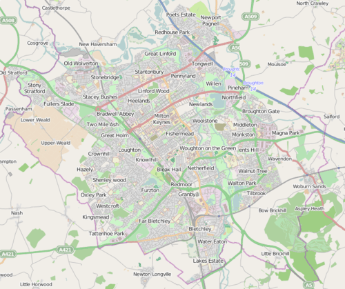 | |
| Rail | ||
| Bus | ||
| Water |
| |
| Other transport | ||