Franklin, Ohio
- Not to be confused with Franklin County, Ohio.
| Franklin, Ohio | ||
|---|---|---|
| City | ||
| ||
| Motto(s): "Keep It Green" | ||
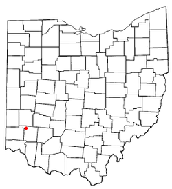 Location of Franklin, Ohio | ||
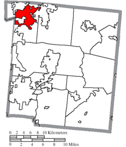 Location of Franklin in Warren County | ||
| Coordinates: 39°33′41″N 84°18′6″W / 39.56139°N 84.30167°WCoordinates: 39°33′41″N 84°18′6″W / 39.56139°N 84.30167°W | ||
| Country | United States | |
| State | Ohio | |
| County | Warren | |
| Founded | 1796 | |
| town | 1814 | |
| city | 1951 | |
| Government | ||
| • Type | Council-city manager | |
| • Mayor | Denny Centers | |
| • City Manager | Sonny Lewis | |
| Area[1] | ||
| • Total | 9.34 sq mi (24.19 km2) | |
| • Land | 9.17 sq mi (23.75 km2) | |
| • Water | 0.17 sq mi (0.44 km2) 1.82% | |
| Elevation | 650 ft (198 m) | |
| Population (2010)[2] | ||
| • Total | 11,771 | |
| • Estimate (2012[3]) | 11,819 | |
| • Density | 1,283.6/sq mi (495.6/km2) | |
| Time zone | UTC-5 (EST) | |
| • Summer (DST) | UTC-4 (EDT) | |
| ZIP code | 45005 | |
| Area code(s) | 937 | |
| FIPS code | 39-28476[4] | |
| GNIS feature ID | 1048758[5] | |
| Website | http://www.franklinohio.org/ | |
Franklin is a city in Warren County, Ohio, United States. The population was 11,771 at the 2010 census.
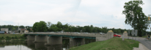
The Great Miami River flows through Franklin. Ohio State Routes 73, 123 and 741 pass through Franklin, while Interstate 75 passes on the east side of the city.
History
Franklin was founded by General William C. Schenck, in 1796.[6] The settlement was named for Benjamin Franklin. Franklin was incorporated in 1814, and became a city in 1951.
One of the first four post offices in Warren County was established Franklin in 1805. The first postmaster was John N.C. Schenck, brother of General Schenck. The Franklin Post Office still stands (in a different location), and is one of four sites in Franklin listed on the National Register of Historic Places, along with the Mackinaw Historic District.
Construction of the Miami and Erie Canal occurred between 1825 and 1845. The canal followed the Great Miami River through Franklin, and the boat traffic led to new commerce. The town soon had a pork slaughterhouse, barrel making factory, sawmill, and whiskey distillery.[7]
Franklin's first mayor, Dr. Absalom Death, was elected at a tavern meeting in 1837. Dr. Death went on to be director of a medical college in Cincinnati. In its history, two doctors in Franklin have been named "Dr. Death".[7]
By the 1850s, the Franklin area was noted for breeding racehorses. One chestnut-colored mare, Nightingale, sired by Mambrino and Wood's Hambletonian, set a 3-mile harness racing record of 6:55½ in 1893.[8]
A railroad was completed with a depot in Franklin in 1872. The town continued to prosper, and by 1890, five paparmaking mills were located in Franklin. The town's economy suffered a setback in 1896, when Franklin's only bank crashed. A longtime and trusted teller had embezzled vast amounts of money, affecting the fortunes of many individuals and businesses.[7]
The town marshal of Franklin, George Basore, was shot and killed in 1906 while attempting to arrest an African-American man, George White. When White was arrested, a crowd of 300 gathered outside the Franklin jail intent on lynching him. The sheriff and two deputies were able to remove White and take him to nearby Lebanon for his safety. The New York Times reported: "The whole town of Franklin is wrought up over the affair. Colored people were chased out without being given time to explain".[9] White died the following year in the electric chair.[10]
In 1907, Franklin's fire chief, B.H. Miller, walked into the police station and shot dead one of the prisoners who had allegedly had an affair with his wife a month earlier.[11]
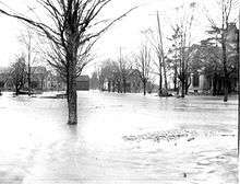
The town was devastated by the Great Flood in March 1913, when the banks of the Great Miami River overflowed.
Franklin opened what was considered the world's first garbage recycling plant in 1971. Designed and built by the Black Clawson Company, the plant recycled metals from solid waste, and used recovered paper fibers to make roofing materials.[12]
In 1989, Ronald Peters, a café owner in Franklin, was alleged to be the principal bookmaker for baseball player Pete Rose.[13]
In 2015, The Museum of Spiritual Art opened.[14]
In 2017, the City of Franklin briefly gained national attention[15] in the week following the racially tinged Charlottsville car attack: the city removed an obscure Confederate marker honoring Robert E. Lee that had existed along the right-of-way of the Dixie Highway[16] for 90 years. The marker had been dedicated in 1927 by the United Daughters of the Confederacy when the Highway was part of Franklin Township.[17]
Geography
According to the United States Census Bureau, the city has a total area of 9.34 square miles (24.19 km2), of which 9.17 square miles (23.75 km2) is land and 0.17 square miles (0.44 km2) is water.[1]
Demographics
| Historical population | |||
|---|---|---|---|
| Census | Pop. | %± | |
| 1810 | 202 | — | |
| 1830 | 584 | — | |
| 1840 | 770 | 31.8% | |
| 1850 | 972 | 26.2% | |
| 1870 | 1,832 | — | |
| 1880 | 2,385 | 30.2% | |
| 1890 | 2,729 | 14.4% | |
| 1900 | 2,724 | −0.2% | |
| 1910 | 2,659 | −2.4% | |
| 1920 | 3,071 | 15.5% | |
| 1930 | 4,491 | 46.2% | |
| 1940 | 4,511 | 0.4% | |
| 1950 | 5,388 | 19.4% | |
| 1960 | 7,917 | 46.9% | |
| 1970 | 10,075 | 27.3% | |
| 1980 | 10,711 | 6.3% | |
| 1990 | 11,026 | 2.9% | |
| 2000 | 11,396 | 3.4% | |
| 2010 | 11,771 | 3.3% | |
| Est. 2017 | 11,735 | [18] | −0.3% |
| Sources:[4][19][20][21][22][23][24][25] | |||
2010 census
As of the census[2] of 2010, there were 11,771 people, 4,667 households, and 3,162 families residing in the city. The population density was 1,283.6 inhabitants per square mile (495.6/km2). There were 5,026 housing units at an average density of 548.1 per square mile (211.6/km2). The racial makeup of the city was 96.2% White, 0.9% African American, 0.2% Native American, 0.5% Asian, 0.4% from other races, and 1.7% from two or more races. Hispanic or Latino of any race were 1.6% of the population.
There were 4,667 households of which 35.9% had children under the age of 18 living with them, 45.9% were married couples living together, 15.7% had a female householder with no husband present, 6.2% had a male householder with no wife present, and 32.2% were non-families. 26.8% of all households were made up of individuals and 9.8% had someone living alone who was 65 years of age or older. The average household size was 2.49 and the average family size was 3.00.
The median age in the city was 36.7 years. 25.5% of residents were under the age of 18; 8.6% were between the ages of 18 and 24; 27.2% were from 25 to 44; 26.3% were from 45 to 64; and 12.5% were 65 years of age or older. The gender makeup of the city was 48.2% male and 51.8% female.
2000 census
As of the census[4] of 2000, there were 11,396 people, 4,553 households, and 3,155 families residing in the city. The population density was 1,251.0 people per square mile (483.0/km²). There were 4,802 housing units at an average density of 527.1 per square mile (203.5/km²). The racial makeup of the city was 97.51% White, 0.82% African American, 0.12% Native American, 0.40% Asian, 0.32% from other races and 0.82% from two or more races. Hispanic or Latino of any race were 0.71% of the population.
There are 4,553 households out of which 33.9% had children under the age of 18 living with them, 51.0% were married couples living together, 13.9% had a female householder with no husband present, and 30.7% were non-families. 26.3% of all households were made up of individuals and 9.9% had someone living alone who was 65 years of age or older. The average household size was 2.48 and the average family size was 2.99.
In the city the population was spread out with 26.6% under the age of 18, 9.1% from 18 to 24, 31.7% from 25 to 44, 20.8% from 45 to 64, and 11.7% who were 65 years of age or older. The median age was 34 years. For every 100 females, there were 90.4 males. For every 100 females age 18 and over, there were 87.2 males.
The median income for a household in the city was $38,142, and the median income for a family was $45,152. Males had a median income of $35,401 versus $24,752 for females. The per capita income for the city was $17,910. About 8.2% of families and 10.1% of the population were below the poverty line, including 12.3% of those under age 18 and 8.4% of those age 65 or over.
Historic population figures
| Year | Population |
|---|---|
| 1900 | 2,724 |
| 1920 | 3,071 |
| 1940 | 4,511 |
| 1950 | 5,388 |
| 1960 | 7,917 |
| 1970 | 10,075 |
| 1980 | 10,711 |
| 1990 | 11,026 |
Education
Schools of the Franklin City School District located in Franklin:
- Anthony Wayne Elementary School (named for Anthony Wayne, an officer in the Revolutionary War).
- Hunter Elementary
- Schenck Elementary (named after General William Schenck, founder of Franklin)
- Pennyroyal Elementary
- Gerke Elementary
- Franklin Junior High School.
- Franklin High School.
Also served by nearby Bishop Fenwick High School, a local Catholic highschool under the Archdiocese of Cincinnati.
Franklin has the Franklin Public Library, a branch of the Franklin-Springboro Public Library.[26]
Notable people
- Samuel Bigger, seventh Governor of Indiana.
- Lewis D. Campbell, U.S. Representative for Ohio.
- Mary Kennedy Carter, teacher and civil rights activist.
- Will Earhart, music educator.
- Bergen Evans, lexicographer, Rhodes Scholar, professor, and television host.
- Edwin F. Harding, commander of U.S. National Guard 32nd Infantry Division.
- Justin Woodward Harding, judge on the tribunal presiding over the Judges' Trial.
- Darrell Hedric, college basketball coach.
- Gene Huff, member of Kentucky House of Representatives and Senate.
- Luke Kennard, Duke Blue Devils men's basketball player, 12th overall pick by the Detroit Pistons in the 2017 NBA Draft
- Travis Lakins, former pitcher for Ohio State Buckeyes baseball, current pitcher for the Boston Red Sox
- Frank Lickliter, professional golfer.
- John Patterson MacLean, Universalist minister, archaeologist, and historian.
- William A. Newell, 18th Governor of New Jersey.
- James F. Schenck, U.S. Navy admiral and brother of Robert
- John N. C. Schenck, first post master of the Miami River Valley and early plotter of Warren County.
- Robert C. Schenck, U.S. Army general and brother of James
- William Cortenus Schenck, American army general in the War of 1812, pioneer surveyor of the Northwest Territory, and founder of Franklin; father of James and Robert
- Derik Steiner, professional football player.
- Shannon Stewart, fashion model and beauty pageant contestant.
- Wilbur P. Thirkield, president of Howard University.
- Bob Timberlake, professional football player.
References
- 1 2 "US Gazetteer files 2010". United States Census Bureau. Archived from the original on 2012-07-14. Retrieved 2013-01-06.
- 1 2 "American FactFinder". United States Census Bureau. Retrieved 2013-01-06.
- ↑ "Population Estimates". United States Census Bureau. Archived from the original on 2013-06-17. Retrieved 2013-06-17.
- 1 2 3 "American FactFinder". United States Census Bureau. Archived from the original on 2013-09-11. Retrieved 2008-01-31.
- ↑ "US Board on Geographic Names". United States Geological Survey. 2007-10-25. Retrieved 2008-01-31.
- ↑ Bogan, Dallas (Jan 29, 1914). "Warren County Local History". Rootsweb.
- 1 2 3 Gorsuch, Geoffrey G. (2005). Franklin. Arcadia.
- ↑ "An Old-Time Record Broken" (PDF). New York Times. Oct 21, 1893.
- ↑ "Negro Kills a Marshall" (PDF). New York Times. Oct 31, 1906.
- ↑ Kramer, Stephen R. (June 7, 2013). "Marshal George E. Basore". Greater Cincinnati Police Museum. Archived from the original on July 28, 2013. Retrieved August 27, 2013.
- ↑ "Kills Rival in his Cell" (PDF). New York Times. Sep 4, 1907.
- ↑ The Franklin Chronicle, August 1971
- ↑ "Reports Say Rose Bet on Baseball". Beaver County Times. April 6, 1989.
- ↑ "The Museum of Spiritual Art (MOSA) The Malhotra Collection". Museum of Spiritual Art. Retrieved April 2016. Check date values in:
|accessdate=(help) - ↑ http://thehill.com/blogs/blog-briefing-room/news/346908-ohio-city-to-remove-robert-e-lee-monument
- ↑ http://www.citybeat.com/news/news-feature/article/20973358/franklins-monument-to-robert-e-lee-removed
- ↑ Rosen, Steven (August 11, 2015). "Ohio's Strange Monument Honoring Robert E. Lee".
It is a large, ruggedly shaped boulder with a bronze plaque in the center, fenced off from the roadway by some petite white pillars and a draped metal chain. The plaque depicts Lee astride his horse, Traveller, and reads, "Erected and Dedicated by the United Daughters of the Confederacy and Friends In Loving Memory of Robert E. Lee and to Mark the Route of the Dixie Highway. ‘The shaft memorial and highway straight attest his worth — he cometh to his own.’ — Littlefield/Erected 1927." ... Cindy Branam, president of the Ohio division of the United Daughters of the Confederacy, said she had never heard of the monument until a recent call from a blogger. Her research shows it appears to be one of three markers her group had installed in Ohio — the others acknowledge actual historic sites, Confederate cemeteries at Johnson’s Island and Columbus. She also supported a new one in Wellston, Ohio, near a battle site... The true irony and oddity about all this is that the monument is across the street from Woodhill Cemetery, which Franklin Township owns. And it has a true Civil War memorial — and a state historical marker — dedicated to area soldiers who fought and died for the Union in the Civil War. Twenty-one of them are buried in the cemetery. In the book The History of Franklin in the Great Miami Valley, contributor Dorothy Scholl tells of the surprise many in the area felt when a motorist knocked the Lee monument off its foundation in 1981. Until the resultant news coverage, few had any idea what the monument was about as they zipped past it. Scholl talked to Judge J.T. Riley, a prominent resident, who said that Franklin businessman Barry Brown spurred the monument’s creation, in part because "Lee did as much as anyone to heal the wounds left by the fighting of the Civil War." If that’s the true purpose of it, and it wasn’t just a tie-in with a then-new highway to the South, it isn’t explained fully on the plaque. As recent tragic events in Charleston, S.C., have shown, those wounds haven’t completely healed yet.
- ↑ "Population and Housing Unit Estimates". Retrieved May 26, 2018.
- ↑ "Population of Civil Divisions Less than Counties" (PDF). Statistics of the Population of the United States at the Tenth Census. U.S. Census Bureau. Retrieved 28 November 2013.
- ↑ "Population of Civil Divisions Less than Counties" (PDF). Statistics of the Population of the United States at the Tenth Census. U.S. Census Bureau. Retrieved 28 November 2013.
- ↑ "Population: Ohio" (PDF). 1910 U.S. Census. U.S. Census Bureau. Retrieved 28 November 2013.
- ↑ "Population: Ohio" (PDF). 1930 US Census. U.S. Census Bureau. Retrieved 28 November 2013.
- ↑ "Number of Inhabitants: Ohio" (PDF). 18th Census of the United States. U.S. Census Bureau. Retrieved 22 November 2013.
- ↑ "Ohio: Population and Housing Unit Counts" (PDF). U.S. Census Bureau. Retrieved 22 November 2013.
- ↑ "Incorporated Places and Minor Civil Divisions Datasets: Subcounty Population Estimates: April 1, 2010 to July 1, 2012". U.S. Census Bureau. Archived from the original on 17 June 2013. Retrieved 25 November 2013.
- ↑ "Homepage". Franklin-Springboro Public Library. Retrieved 3 March 2018.
Further reading
- Elva R. Adams. Warren County Revisited. [Lebanon, Ohio]: Warren County Historical Society, 1989.
- The Centennial Atlas of Warren County, Ohio. Lebanon, Ohio: The Centennial Atlas Association, 1903.
- Mabel Eldridge and Dudley Bryant. Franklin in the Great Miami Valley. Edited by Harriet E. Foley. Franklin, Ohio: Franklin Area Historical Society, 1982.
- Harriet E. Foley, editor. Carlisle: The Jersey Settlement in Ohio, 1800–1990. 2nd ed. [Carlisle, Ohio?]: The Editor, 1990.
- Josiah Morrow. The History of Warren County, Ohio. Chicago: W.H. Beers, 1883. (Reprinted several times)
- Ohio Atlas & Gazetteer. 6th ed. Yarmouth, Maine: DeLorme, 2001. ISBN 0-89933-281-1
- William E. Smith. History of Southwestern Ohio: The Miami Valleys. New York: Lewis Historical Publishing, 1964. 3 vols.
External links
Municipalities and communities of Warren County, Ohio, United States | ||
|---|---|---|
| Cities | 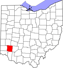 | |
| Villages | ||
| Townships | ||
| CDPs | ||
| Unincorporated communities |
| |
| Ghost towns | ||
| Footnotes | ‡This populated place also has portions in an adjacent county or counties | |