Wayne Township, Warren County, Ohio
| Wayne Township, Warren County, Ohio | |
|---|---|
| Township | |
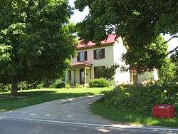 Moses McKay House, built 1818 | |
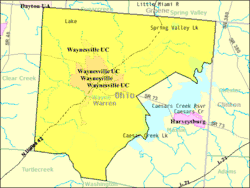 Detailed map of Wayne Township | |
| Coordinates: 39°31′46″N 84°4′55″W / 39.52944°N 84.08194°WCoordinates: 39°31′46″N 84°4′55″W / 39.52944°N 84.08194°W | |
| Country | United States |
| State | Ohio |
| County | Warren |
| Area | |
| • Total | 46.3 sq mi (120.0 km2) |
| • Land | 44.8 sq mi (116.1 km2) |
| • Water | 1.5 sq mi (3.9 km2) |
| Elevation[1] | 722 ft (220 m) |
| Population (2000) | |
| • Total | 7,250 |
| • Density | 161.7/sq mi (62.4/km2) |
| Time zone | UTC-5 (Eastern (EST)) |
| • Summer (DST) | UTC-4 (EDT) |
| FIPS code | 39-82306[2] |
| GNIS feature ID | 1087123[1] |
Wayne Township is one of the eleven townships of Warren County, Ohio, United States. It is located in the northeast part of the county and includes the village of Waynesville, Ohio. Its population in 2000 was 7,250, up from 5,744 in 1990; 4,436 of this total lived in the unincorporated portions of the township.[3] Waynesville is noted for its antique stores and is the home of a sauerkraut festival. Caesar Creek State Park is located here.
Geography
Located in the northeastern corner of the county, it borders the following townships:
- Sugarcreek Township, Greene County - north
- Spring Valley Township, Greene County - northeast
- Chester Township, Clinton County - east
- Massie Township - southeast
- Washington Township - south
- Turtlecreek Township - southwest
- Clearcreek Township - west
- Washington Township, Montgomery County - northwest
The villages of Corwin and Waynesville in the township, as are the communities of Mount Holly and Crosswick. The Little Miami River, which forms a portion of the township's boundary, flows through the middle of the township. The Little Miami Bike Trail, along the route of the former Little Miami Railroad, also passes through the township.
The portion of Wayne Township east of the Little Miami is in the Virginia Military District and was surveyed with the metes and bounds system, while the area west of the Little Miami was surveyed on the same plan as used in the Symmes Purchase.
Name and history
Named for General "Mad" Anthony Wayne, it is one of twenty Wayne Townships in Ohio.
One of the original townships of Warren County, Wayne Township was organized on May 10, 1803.[4]
Government
The township is governed by a three-member board of trustees, who are elected in November of odd-numbered years to a four-year term beginning on the following January 1. Two are elected in the year after the presidential election and one is elected in the year before it. There is also an elected township fiscal officer,[5] who serves a four-year term beginning on April 1 of the year after the election, which is held in November of the year before the presidential election. Vacancies in the fiscal officership or on the board of trustees are filled by the remaining trustees.
Public services
Most of the township is in the Wayne Local School District, but parts are in the Lebanon, Spring Valley, Clinton Massie and Xenia districts.
The township is mainly in the Waynesville telephone exchange, but parts are in the Spring Valley, Bellbrook, Lebanon, and Centerville exchanges.
References
- 1 2 "US Board on Geographic Names". United States Geological Survey. 2007-10-25. Retrieved 2008-01-31.
- ↑ "American FactFinder". United States Census Bureau. Retrieved 2008-01-31.
- ↑ Warren County, Ohio — Population by Places Estimates Ohio State University, 2007. Accessed 15 May 2007.
- ↑ The History of Warren County, Ohio: Containing a History of the County ; Its Townships, Towns. W.H. Beers & Company. 1882. p. 274.
- ↑ §503.24, §505.01, and §507.01 of the Ohio Revised Code. Accessed 4/30/2009.
External links
Municipalities and communities of Warren County, Ohio, United States | ||
|---|---|---|
| Cities | 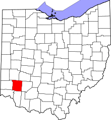 | |
| Villages | ||
| Townships | ||
| CDPs | ||
| Unincorporated communities |
| |
| Ghost towns | ||
| Footnotes | ‡This populated place also has portions in an adjacent county or counties | |