Palk Strait
| Palk Strait பாக்கு நீரிணை | |
|---|---|
 Palk Strait | |
| Location | Laccadive Sea–Bay of Bengal |
| Coordinates | 10°00′N 79°45′E / 10.000°N 79.750°ECoordinates: 10°00′N 79°45′E / 10.000°N 79.750°E |
| Type | Strait |
| Etymology | Robert Palk |
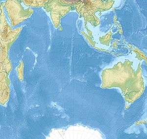
| Part of | Indian Ocean |
| Basin countries | India, Sri Lanka |
| Max. width | 82 kilometres (51 mi) |
The Palk Strait (Tamil: பாக்கு சலசந்தி / பாக்கு நீரிணை, Sinhala: පෝක් සමුද්ර සන්ධිය Pok Samudra Sandhiya) is a strait between the Tamil Nadu state of India and the Mannar district of the Northern Province of the island nation of Sri Lanka. It connects the Bay of Bengal in the northeast with Palk Bay in the southwest.[1] The strait is 53 to 82 kilometres (33 to 51 mi) wide.[2] Several rivers flow into it, including the Vaigai River of Tamil Nadu. The strait is named after Robert Palk, who was a governor of Madras (1755–1763) during the Company Raj period.[3]
Geography
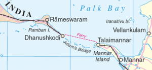
Palk Bay is studded at its southern end with a chain of low islands and reef shoals that are collectively called Adam's Bridge,[3] since ages it is popularly known in Hindu Mythology as "Ram Setu" i.e. The Bridge of Rama.[4] This chain extends between Dhanushkodi on Pamban Island (also known as Rameswaram Island) in Tamil Nadu and Mannar Island in Sri Lanka. The island of Rameswaram is linked to the Indian mainland by the Pamban Bridge.
History
As from 1914, there used to be regular trains from Madras/Chennai to Dhanushkodi, a ferry to Talaimannar on Mannar Island, and thence a train to Colombo. In 1964, a cyclone destroyed Dhanushkodi and the railway and caused severe damage along the shores of Palk Strait and Palk Bay.[5] Dhanushkodi was not rebuilt and the railway from Talaimannar to Mahawilachchiya in Sri Lanka was given up due to the civil war (It was later completely rebuilt). There was a ferry between small piers in Rameswaram and Talaimannar, but this was discontinued till date.[6]
Proposed canal
The shallow waters and reefs of the strait make it difficult for large ships to pass through, although fishing boats and small craft carrying coastal trade have navigated the strait for centuries. Large ships must travel around Sri Lanka. Construction of a shipping canal through the strait was first proposed to the British government of India in 1860, and a number of commissions have studied the proposal up to the present day. The most recent study of the Sethusamudram Shipping Canal Project, as it is now called, was an environmental impact assessment and a technical feasibility study commissioned by the Tamil Nadu government in 2004.[7]
However, the plan encountered opposition from various religious circles. The Indian epic poem Ramayana, written thousands of years ago in Sanskrit and an important Hindu text, recounts how Rama, with the help of an army of vanaras, built a bridge of stones across the sea to Lanka to rescue his wife Sita from the Asura king Ravana. The Ram Karmabhoomi movement, encouraged by a NASA satellite photograph of Rama's Setu, was formed to prevent the shipping canal from being built.[8]
See also
References
- ↑ Map of Sri Lanka with Palk Strait and Palk Bay
- ↑ Distances measured on Google Earth
- 1 2

- ↑ "Adam's bridge". Encyclopædia Britannica. 2007. Retrieved 2007-09-14.
- ↑ Land's end
- ↑ Sri Lanka, India to relaunch ferry service after three decades
- ↑ Harnessing the Troubled Waters: Sethusamudram Canal Project
- ↑ "Hanuman bridge is myth: Experts". Times of India. October 19, 2002. Retrieved 2011-04-25.
External links
| Wikimedia Commons has media related to Palk Strait. |