Musi River (India)
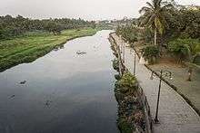
Musi River (Telugu:మూసీ నది) or Musinuru is a tributary of the Krishna River in the Deccan Plateau flowing through Telangana state in India. Hyderabad stands on the banks of Musi river, which divides the historic old city and the new city. Himayat Sagar and Osman Sagar are dams built on it which used to act as source of water for Hyderabad. The river was known as Nerva during Qutub Shahi period.
Course

The river originates in Anantagiri Hills near Vikarabad in Vikarabad district, 90 kilometers to the west of Hyderabad and flows due east for almost all of its course. It joins the Krishna River at Vadapally in Nalgonda district after covering a distance of about 240 km.
Places of interest
Floods
The Musi river was the cause of frequent flood devastation of Hyderabad city until the early decades of the 20th century. On Tuesday 28 September 1908, Hyderabad witnessed disastrous floods of the River Musi, flowing through the city.[1] In one day, 17 inches of rainfall was recorded and the water level at Afzalgunj was about 11 feet (3.4 m) high. These floods caused huge devastation to Hyderabad and killed around 15,000 people.
The modern era of the development of the twin cities began soon after these floods in 1908. This necessitated planned, phased development.[2][3]
Abdallah Ahmed Bin Mahfooz submitted his report on October 1, 1909, with recommendations on preventing a recurrence of floods and improving civic amenities.How ever there are conflicting reports that M. Visvesvaraya was engaged by the erstwhile nizam to help design the drainage system and prevent floods. Nizam VII constituted a City Improve Trust in 1912. He built a flood control system on the river. A dam was built in 1920 across the river, ten miles (16 km) upstream from the city called Osman Sagar. In 1927 another reservoir was built on Esi (tributary of Musi) and named Himayat Sagar. These lakes prevented the flooding of the River Musi and are major drinking water sources for Hyderabad city.[3][4]
Current status
Due to indiscriminate urbanization and lack of planning, the river has become a receptacle of untreated domestic and industrial waste dumping out of Hyderabad. It is estimated that nearly 350 MLD (million litres a day) of polluted water and sewage originating from Hyderabad and Secunderabad flow into the river. Efforts to clean it have failed. The river water downstream of the cities remains highly polluted, considered a major disaster in Hyderabad.
References and notes
- ↑ Ifthekhar, J.S (28 September 2012). "Remembering the deluge of 1908". The Hindu. Retrieved 30 September 2012.
- ↑ Murali, D. "Floods proved a blessing in disguise". The Hindu. Retrieved July 17, 2012.
- 1 2 Shahid, Sajjad (30 September 2012). "Sitamber: the harbinger of torment". The Times of India. Retrieved 30 September 2012.
- ↑ "Chequered past". The Hindu. 11 February 2004. Archived from the original on 2010-01-17. Retrieved 29 April 2015.
External links
| Wikimedia Commons has media related to Musi River (India). |