Karnaphuli
| Karnaphuli River | |
|---|---|
.jpg) Aerial view of the Karnaphuli River estuary | |
| Countries | India, Bangladesh |
| Cities | Chittagong |
| Physical characteristics | |
| Main source | Saitah, Mizoram, India |
| River mouth | Bay of Bengal |
| Length | 270 kilometres (170 mi) |
.jpg)
Karnaphuli (Bengali: কর্ণফুলি Kôrnophuli; also spelt Karnafuli[1]), or Khawthlangtuipui (in Mizo, meaning "western river"), is the largest and most important river in Chittagong and the Chittagong Hill Tracts. It is a 667-metre (2,188 ft) wide river in the south-eastern part of Bangladesh. Originating from the Saitah village of Mamit district in Mizoram, India, it flows 270 kilometres (170 mi) southwest through Chittagong Hill Tracts and Chittagong into the Bay of Bengal. It is said to "represent the drainage system of the whole south-western part of Mizoram."[2] Principal tributaries include the Kawrpui River or Thega River, Tuichawng River and Phairuang River. A large hydroelectric power plant using Karnaphuli river was built in the Kaptai region during the 1960s. The mouth of the river hosts Chittagong's sea port, the main port of Bangladesh.
Chittagong City
Chittagong is situated on the banks of the Karnaphuli River between the Chittagong Hill Tracts and the Bay of Bengal. The city is a noteworthy seaside seaport city and monetary focus in southeastern Bangladesh. The Chittagong Metropolitan Area has a populace of more than 6.5 million,[3] making it the second biggest city in Bangladesh. It is the capital of an eponymous locale and division. A water treatment plant has been set up by Chittagong Port Authority to source water from the Karnaphuli river for its uses. The plant will make the port self-reliant in its water needs.[4]
Transportation
The Government has awarded a contract to build a two lane Karnaphuli tunnel underneath the Karnaphuli river to China Communication Construction Company (CCCC). This will be the first underwater tunnel in Bangladesh. CCCC will receive $706 million for its services with total costs expected to be over $1 billion.[5]
Aquatic life
The river is home to Ganges river dolphin, which is an endangered species.[6] Hilsa used to be common in the river, but have nearly disappeared from the river due to pollution.[7]
Kaptai dam
The Kaptai Dam is the location of the Karnafuli Hydroelectric Power Station, constructed in Kaptai in 1962 and the only hydro-electric power plant in the country. An earth-filled dam on the Karnaphuli River, the Kaptai Dam created the Kaptai Lake, which acts as the water reservoir for the hydropower station. The power plant produces a total of 230 megawatts of electricity.When then east Pakistan built the dam, Indian Prime Minister Jawaharlal Nehru didn't object even though it resulted in part of Indian side getting submerged and inflow of more than 40000 refugees.[8]
Pollution
Like many rivers in Bangladesh, Karnaphuli is heavily polluted by agricultural runoff. Reducing the amount of oxygen available and harming aquatic life in the river.[9] In 2015, a train carrying oil crashed over a tributary of the river. The spill caused environmental degradation.[10]
Gallery
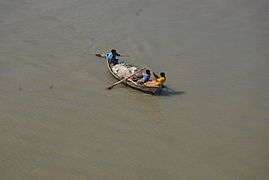 Boat on Karnaphuli River
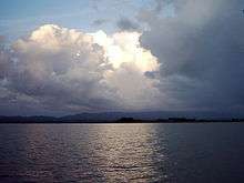
.jpg) View of the river
View of the river.jpg) Ships at Karnaphuli River
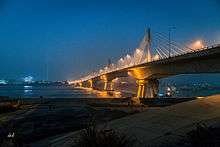
Ships at Karnaphuli River.jpg) Port of Chittagong and Karnaphuli River at night
Port of Chittagong and Karnaphuli River at night
See also
References
- ↑ Mesbah-us-Saleheen and Sifatul Quader Chowdhury (2012), "Karnafuli River", in Sirajul Islam and Ahmed A. Jamal, Banglapedia: National Encyclopedia of Bangladesh (Second ed.), Asiatic Society of Bangladesh
- ↑ Pachuau, Rintluanga (1 January 2009). Mizoram: A Study in Comprehensive Geography. Northern Book Centre. p. 40. ISBN 978-81-7211-264-6. Retrieved 8 August 2012.
- ↑ E-Vision Software Limited. "Economics Landscape of Chittagong". chittagongchamber.com.
- ↑ Chowdhury, Sarwar A. "Chittagong port sets up water treatment plant". thedailystar.net. The Daily Star. Retrieved 16 July 2015.
- ↑ "Cabinet okays Karnaphuli river tunnel project". thedailystar.net. The Daily Star. Retrieved 16 July 2015.
- ↑ "Ganges River dolphin OVERVIEW". worldwildlife.org. World Wildlife Fund. Retrieved 17 December 2015.
- ↑ Roy, Pinaki. "Hilsa spawning less and less". thedailystar.net. The Daily Star. Retrieved 16 July 2015.
- ↑ Bari, M Fazlul (2012). "Dam". In Islam, Sirajul; Jamal, Ahmed A. Banglapedia: National Encyclopedia of Bangladesh (Second ed.). Asiatic Society of Bangladesh.
- ↑ Roy, Pinaki (2 May 2015). "Hilsa spawning less and less". The Daily Star. Retrieved 16 July 2015.
- ↑ "Spilled oil flows towards Karnaphuli". The Daily Star. 20 June 2015. Retrieved 16 July 2015.
| Wikimedia Commons has media related to Karnafuli River. |