Shingo River
The Shingo River is a tributary of the Indus River, and flows through Gilgit-Baltistan and Kargil regions.
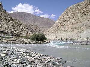
Course
The river originates in the Chhota Deosai plains in the Astore District, north of Minimarg and flows east. The Shigar River, which originates in the Bara Deosai Plateau to the north, also flows east and joins Shingo before it enters the Indian-administered Kargil district near Dalunang. In the Kargil district, Shingo is joined by the Dras River, which originates near Zojila Pass and flows northeast. The flow of Shingo is then doubled. The two combined rivers join the Suru River flowing north at Kharul, 7 km north of Kargil. Suru/Shingo continues to flow north and reenters the Skardu District of Baltistan. It joins the Indus River from the left near Olding.[1]
The Shingo river is clearer than other rivers in Ladakh because it is formed from melting ice. It flows through Chanigund.
Environment
The Shingo River runs north of the Line of Control dividing the Indian- and Pakistani-administered portions of Kashmir. Gultari is the largest city on its course. A road runs parallel to the river, which once connected Astor to Kargil. Once in the Kargil district, the valley of the river houses India's National Highway 1 that connects the Kashmir Valley and Ladakh. After reentering Baltistan, its valley support the Shingo River Road, which is also called the Kargil–Skardu Road.
References
- ↑ Kapadia, Harish (1999), Across Peaks & Passes in Ladakh, Zanskar & East Karakoram, Indus Publishing, pp. 226–, ISBN 978-81-7387-100-9