List of major rivers of India
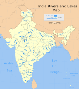
The rivers of India play an important role in the lives of the Indians. They provide potable water, cheap transportation, electricity, and the livelihood for a large number of people all over the country. This easily explains why nearly all the major cities of India are located by the banks of rivers. The rivers also have an important role in Hindu Religion and are considered holy by all Hindus in the country.[1]
Seven major rivers along with their numerous tributaries make up the river system of India. The largest basin system of the rivers pour their waters into the Bay of Bengal; however, some of the rivers whose courses take them through the western part of the country and towards the east of the state of Himachal Pradesh empty into the Arabian Sea. Parts of Ladakh, northern parts of the Aravalli range and the arid parts of the Thar Desert have inland drainage.
All major rivers of India originate from one of the following main watersheds:
- Aravalli range
- Himalaya and Karakoram ranges
- Sahyadri or Western Ghats in western India
- Vindhya and Satpura ranges a
Himalayan glaciers in the Indian subcontinent are broadly divided into the three river basins, namely the Indus, Ganga and Brahmaputra. The Indus basin has the largest number of glaciers (3500), whereas the Ganga and Brahmaputra basins contain about 1000 and 660 glaciers, respectively.[2] Ganga is the largest river system in India.However these rivers are just three among many.Some other examples of rivers are narmada, tapi, godwari etc.
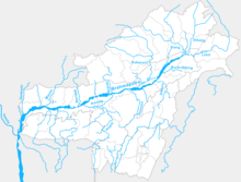
The Indo-Gangetic Plains
Known as Ganga-(गँगा सतलुज का मैदान), this area is drained by 16 major rivers. The major Himalayan Rivers are the Indus, Ganges, and Brahmaputra. These rivers are long, and are joined by many large and important tributaries. Himalayan rivers have long courses from their source to sea (in India Arabian sea and Bay of Bengal).
Aravalli Range River System
Following rivers flow from the Aravalli range, both northwards to Yamuna as well as southwards to Arabian Sea.
- North-to-south flowing rivers, originate from the western slopes of Aravalli range in Rajasthan, pass through the southeastern portion of the Thar Desert, and end into Gujarat.
- Luni River, originates in the Pushkar valley near Ajmer, ends in the marshy lands of Rann of Kutch.
- Sakhi river, ends in the marshy lands of Rann of Kutch.
- Sabarmati River, originates one the western slopes of Aravalli range of the Udaipur District, end into the Gulf of Cambay of Arabian Sea.
- West to north-west flowing rivers, originate from the western slopes of Aravalli range in Rajasthan, flow through semi-arid historical Shekhawati region, drain into southern Haryana. Several Ochre Coloured Pottery culture sites, also identified as late Harappan phase of Indus Valley Civilisation culture,[3] has been found along the banks of these rivers.
- Sahibi River, originates near Manoharpur in Sikar district flows through Haryana, along with its following tributaries:[4][5][6][7]
- Dohan river, tributary of Sahibi river, originates near Neem Ka Thana in Alwar district).
- Sota River, tributary of Sahibi river, merges with Sahibi river at Behror in Alwar district.
- Krishnavati river, former tributary of Sahibi river, originates near Dariba copper mines in Rajsamand district of Rajasthan, flows through Patan in Dausa district and Mothooka in Alwar district, then disappears in Mahendragarh district in Haryana much before reaching Sahibi river.
- Sahibi River, originates near Manoharpur in Sikar district flows through Haryana, along with its following tributaries:[4][5][6][7]
- West to north-east flowing rivers, originating from the eastern slopes of Aravalli range in Rajasthan, flow northwards to Yamuna.
- Chambal River, a southern-side tributary of Yamuna river.
- Banas River, a northern-side tributary of Chambal river.
- Berach River, a southern-side tributary of Banas River, originates in the hills of Udaipur District.
- Ahar River, a right-side (or eastern side) tributary of the Berach river, originates in the hills of Udaipur District, flows through Udaipur city forming the famous Lake Pichola.
- Wagli Wagon River, a right-side tributary of the Berach River.
- Gambhiri River, a right-side tributary of the Berach river.
- Orai River, a right-side tributary of the Berach River.
- Berach River, a southern-side tributary of Banas River, originates in the hills of Udaipur District.
- Banas River, a northern-side tributary of Chambal river.
- Chambal River, a southern-side tributary of Yamuna river.
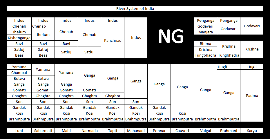
Ganges River System
The major rivers in this system are (in order of merging, from west to east)
- Ganga - Starting from Vidyasagar Gangotri Glaciinto er, Uttarakhand
- Chambal -Flows through Madhya Pradesh, Rajasthan and merges into Yamuna in Uttar Pradesh
- Betwa - Not Himalayan river, covers Madhya Pradesh and Uttar Pradesh before merging Yamuna
- Yamuna - Yamuna runs its most of the course parallel to Ganga before contributing its water to Ganga at Allahabad
- Gomti - Starts near the junction of three borders viz. Nepal, Uttarakhand and UP
- Ghaghra - Starts in Nepal near Uttarakhand
- Son - Not Himalayan river, covers MP, UP, Jharkhand and Bihar. Largest of Ganga's southern tributaries
- Gandak - Starts from Nepal
- Kosi - Starts from Bihar, near Indo-Nepal border
- Brahmaputra - Merges with Ganga to form the grand river (but short in length) - Padma in Bangladesh. By now, flow velocity of both rivers slow down to considerable extent as they are in plains now.
Before entering Bangladesh, Ganga leaves a distributary Hoogly, which provides water for irrigation in West Bengal
Brahmaputra River System
- Yarlung Tsangpo River - originates and forms the upper stream of Brahmaputra in Tibet
- Siang - main river after it enters India in the state of Arunachal Pradesh
- Dibang - major tributary flowing through Arunachal Pradesh before merging into the Brahmaputra River in Assam.
- Lohit - one of the three major tributaries of Brahmaputra flowing through Arunachal Pradesh from the easternmost India.
- Brahmaputra - runs across the state of Assam from East to West, entering Bangladesh afterwards.
- Teesta - one of the largest tributaries of Brahmaputra; originating in the borders of Sikkim and Tibet, flowing South it joins Brahmaputra in Bangladesh.
- Jamuna River (Bangladesh) - the Brahmaputra is known as Jamuna in Bangladesh.
- Padma River - the Jamuna river merges with Padma in Bangladesh before finally falling into the Bay of Bengal.
Indus River system
The Indus River originates in the northern slopes of the Kailash range near Lake Manasarovar in Tibet. Although most of the river's course runs through neighbouring Pakistan, as per as regulation of Indus water treaty of 1960, India can use only 20 percent of the water in this river. A portion of it does run through Indian territory, as do parts of the courses of its five major tributaries, listed below. These tributaries are the source of the name of the Punjab of South Asia; the name is derived from the punch ("five") and aab ("water"), hence the combination of the words (Punjab) means "land with the water of five rivers". The Indus is 3,200 kilometres (2,000 mi) long.
The major rivers in Indus river system are (in order of their length):
Annual flows and other data
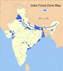
India experiences an average precipitation of 1,170 millimetres (46 in) per year, or about 4,000 cubic kilometres (960 cu mi) of rains annually.[8] Some 80 percent of its area experiences rains of 750 millimetres (30 in) or more a year. However, this rain is not uniform in time or geography. Most of the rains occur during its monsoon seasons (June to September), with the northeast and north receiving far more rains than India's west and south. Other than rains, the melting of snow year round over the Himalayas feeds the northern rivers to varying degrees. The southern rivers, however experience more flow variability over the year. For the Himalayan basin, this leads to flooding in some months and water scarcity in others. Despite extensive river system, safe clean drinking water as well as irrigation water supplies for sustainable agriculture are in shortage across India, in part because it has, as yet, harnessed a small fraction of its available and recoverable surface water resource.[9] India harnessed 761 cubic kilometres (183 cu mi) (20 percent) of its water resources in 2010, part of which came from unsustainable use of groundwater. Of the water it withdrew from its rivers and groundwater wells, India dedicated about 688 cubic kilometres (165 cu mi) to irrigation, 56 cubic kilometres (13 cu mi) to municipal and drinking water applications and 17 cubic kilometres (4.1 cu mi) to industry.[8]
According to 2011 report of the Food and Agriculture Organization of the United Nations, India's basin wise distribution of catchment area and utilizable surface water resources is presented in the following table:[8]
| Basin number | River basin unit | Region | Draining into | Catchment area (% of river irrigated India) | Average runoff (km3) | Additional available surface water (km3) |
|---|---|---|---|---|---|---|
| 1.1 | Ganges (GBM) | North | 26.5 | 525.02 | 250 | |
| 1.2 | Brahmaputra (GBM) | Northeast | 6 | 537.24 | 24 | |
| 1.3 | Meghna/Barak (GBM) | East | 1.5 | 48.36 | ||
| 2 | Other Northeast rivers | Northeast | 1.1 | 31 | ||
| 3 | Subernarekha | East-southeast | Bay of Bengal | 0.9 | 12.37 | |
| 4 | Brahmani-Baitarani | East-southeast | Bay of Bengal | 1.6 | 28.48 | 6.8 |
| 5 | Mahanadi | Central-east | Bay of Bengal | 4.4 | 66.88 | 18.3 |
| 6 | Godavari | Central | Bay of Bengal | 9.7 | 110.54 | 50 |
| 7 | Krishna | Central | Bay of Bengal | 8 | 78.12 | 76.3 |
| 9 | Pennar | Southeast | Bay of Bengal | 1.7 | 6.32 | 58 |
| 10 | Kaveri | South | Bay of Bengal | 2.5 | 21.36 | 6.9 |
| 10 | East flowing rivers between Mahanadi and Pennar | Central-east | Bay of Bengal | 2.7 | 22.52 | 19 |
| 11 | East flowing rivers between Kanyakumari and Pennar | Southeast | Bay of Bengal | 3.1 | 16.46 | 13.1 |
| 12 | West flowing rivers between Tadri and Kanyakumari | Southwest | Arabian Sea | 1.7 | 113.53 | 16.7 |
| 13 | West flowing rivers between Tapi and Tadri | Southwest | Arabian Sea | 1.7 | 87.41 | 24.3 |
| 14 | Tapi | Central-west | Arabian Sea | 2 | 14.88 | 11.9 |
| 15 | Narmada | Central-west | Arabian Sea | 3.1 | 45.64 | 14.5 |
| 16 | Mahi | Northwest | Arabian Sea | 1.1 | 11.02 | 34.5 |
| 17 | Sabarmati | Northwest | Arabian Sea | 0.7 | 3.81 | 3.1 |
| 18 | West flowing rivers between Kutch and Saurashtra | Northwest | Arabian Sea | 10 | 15.1 | 1.9 |
| 19 | Rajasthan inland basin | Northwest | 0 | Negligible | 15 | |
| 20 | Indus tributaries | Northwest | 10 | 73.31 | 46 | |
| Total (per International Treaty) | 100 | 1869.37 |
The Peninsular River system
The main water divide in peninsular rivers is formed by the Western Ghats, which run from north to south close to the western coast. Most of the major rivers of the peninsula such as the Mahanadi, the Godavari, the Krishna and the Kaveri flow eastwards and drain into the Bay of Bengal. These rivers make delta at their mouths. The Narmada, Periyar and Tapti are the only long rivers, which flow west and make estuaries.
See also
References
- ↑ Sunil Vaidyanathan, Rivers of India, ISBN 978-8189738884, 2012
- ↑ "Archived copy" (PDF). Archived from the original (PDF) on 2015-05-14. Retrieved 2015-09-03. page no 361
- ↑ Gupta, S.P. (ed.) (1995), The lost Sarasvati and the Indus Civilization, Jodhpur: Kusumanjali Prakashan
- ↑ Cultural Contours of India: Dr. Satya Prakash Felicitation Volume, Vijai Shankar Śrivastava, 1981. ISBN 0391023586
- ↑ Sahibi river
- ↑ Books: Page 41, 42, 43, 44, 47 (b) Sahibi Nadi (River), River Pollution, By A.k.jain
- ↑ Minerals and Metals in Ancient India: Archaeological evidence, Arun Kumar Biswas, Sulekha Biswas, University of Michigan. 1996. ISBN 812460049X.
- 1 2 3 FAO, India - Rivers Catchment, Aquastat, United Nations (2011)
- ↑ K.L. Rao, India's Water Wealth, ISBN 978-8125007043, 1979